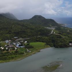
Dagangkou Hamlet is located on the north bank of the Xiuguluan River estuary in Fengbin Township, Hualien County. The traditional name of the place is Lanun, which means the village below, and the traditional name of the hamlet was Ciporan. During the Qing period, the hamlet was called Sipuolan, Xuepuolan, Xiuguluan, Xiuguluan, Zhiwulan, and so on. It was not until 1887 when Puyuma and Ouyang Jun opened the port that the name was changed to Dagangkou. In the same year, the Dagangkou (Cepo’) incident occurred. After the incident, the tribesmen who had moved to other places were called to return to the community. They chose a settlement north of the original site, which is the present Gangkou hamlet. During the Japanese occupation, due to the gradual population increase, some people began to move south to live in the Dagangkou hamlet.
Amis
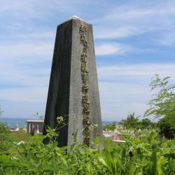
The Cholera Incident Memorial Monument is located in the cemetery area of the Chong’an Hamlet in Chenggong Township, Taitung County. This cholera incident occurred in 1946, when a man from the Yiwan Hamlet fell ill after eating seaweed that he had collected. He was sent back to Chong’an Hamlet, however, the disease spread quickly. It was found after inspection that it was an infectious disease of cholera. At that time there was a shortage of medicine because the war had just ended. The patients were quarantined in the hamlet but could only receive basic treatment. The dead were sent to the beach for incineration. No tombstones were set up and no names were registered. Decades later, the families of the victims were determined to find out the truth. The town office took the initiative to assist in the investigation and finally established a memorial in 2006 to detail the incident.

The Pasongan Hamlet is located between Kinaloka Creek and Pengzicun Creek in Changbin Township, Taitung County. It is rumored to have been established by the Amis tribe who emigrated from Dagangkou Hamlet in Fengbin Township, Hualien County in 1884. As the arable land was small at the time, and that the Amis people were long term oppressed by other indigenous groups from the mountainous area, they moved all the way to the south. In addition, they have been defeated by the Qing army. There is another saying that the Pasongan Hamlet was formed by Amis people of the Wushibi group that came out on its own in 1888. The original site of the hamlet is on the platform on the west side of the current site. The traditional name is Cafongai or Chiganadai, which means big stone, as it was named after two prehistoric boulders that were there. During the Japanese occupation, the hamlet was moved here for management convenience.

The Nanzhuhu Hamlet is located in Changbin Township, Taitung County. It was formerly known as Bakaraatsu, named after the white crabs that lived in nearby paddy fields. Amis people used to live in the hillside west of what is the current Zuhu village. However, at the end of the Qing period, there was a land dispute with the local Pingpu people, and they were cursed that if they lived here for a long time, there would be disasters. The Amis people of the local Zhuhu group and the Saobie group were deeply frightened of ghosts, and so they moved to the south and north. South is now the Nanzhuhu Hamlet, while north is the Yongfu hamlet that sits at the higher plateau on the left bank of Dade River. In the post-war period, the Nanzhuhu Hamlet was split into Nanzhuhu on the top and Xiakan on the bottom.
Antong Hot Spring is located on the north bank of Antong River in Yuli Township, Hualien County. Natural hot spring was discovered in 1904 by a Japanese, who went up the mountain to gather camphor. In the middle of the Japanese occupation, the Government-General in Taiwan built a police hostel here and set up public baths, which gradually developed into a hot spring resort. In the post-war period, the private industry bought and operated it in 1974 and changed its name to Antong Hot Spring Hotel.
To this day, the building itself still retains part of the wooden bungalows that were built in the Japanese Occupation period. The Japanese sliding doors and tatami floors are well preserved. In 2014, the Executive Yuan Cultural and Construction Council announced it as an important historical building.
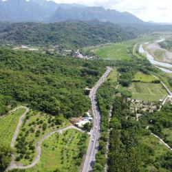
The Yu-Chang Highway, which runs through Hualien County and Taitung County, was excavated in 1875. The highway stretches mainly along the Antong Valley and deep into the coastal mountains. After passing through a tunnel, it then follows the road between the Lujiao Creek and Ningpu Creek that leads to Ningpu Village in Changbin Township.
The construction of the Yu-Chang Highway was actually based on the Antong Traversing Historic Trail. At that time (Qing period), General Wu Guangliang, who was stationed in Yuli, led the soldiers to excavate Pushige Chengguang’ao passage. This became the outer port of the middle section of the Huadong Rift Valley on the other side of the Coastal Mountains. During the Japanese occupation, the Government-General in Taiwan renamed the place Hongzuo Traversing Trail. Later, when the route was changed from Antong to Zhuhu, the trail was renamed to Antong Traversing Trail.

Shitiping is located on the coastal reef area on the south side of Shiti Port in Fengbin Township, Hualien County. The traditional name is Tilaan, which means a place to stay overnight. Before the provincial highway 11 was established, people heading north to Maogong had to travel on foot and on return, they needed to stay overnight in this place. During the Qing period, when the commander-in-chief Wu Guangliang led his troops here to open the road, he saw the stair-like formation of the rocks and named the place Shitiping (Rock Stairs). Over the past 100 years, the Kavalan, Amis, and Han people have successively moved to the vast land at the foot of the mountain on the east side of Shitiping. By the 1990s, the natural sea-eroded reef landscape of Shitiping had become a famous tourist attraction.
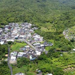
The Gangkou Hamlet is located about 500 meters from the north bank of the Xiuguluan River in Fengbin Township, Hualien County. The traditional name is Makotaay, which means the muddy stream because there is a small stream on the north side of the hamlet and when it rains the stream becomes muddy. In the past, the ancestors of the Gangkou Hamlet lived in the old Ciporan Hamlet. After the Cepo’ Incident in 1887, the tribesmen who had moved to other places were called to return to settle in a hamlet not far from the original site, which is the present Gangkou Hamlet.

The Cepo’ Incident Monument is located inside Jingpu Elementary School in Fengbin Township, Hualien County. It was established in 2014, which is the 127th anniversary of the Cepo’ Incident.
The Cepo’ incident happened at the end of the Qing Dynasty, when Wu Guangliang, the commander-in-chief of all roads in Houshan, was resisted by the Amis people of Jingpu and Gangkou area for excavating roads for Shuiwei to Dagangkou port (Cepo’). Therefore, in 1877, General Lin was sent to lead a troop to suppress the Amis people. Almost a hundred Amis people were killed at the incident, and the surviving tribesmen fled, dispersed to the east coast and the Huadong Rift Valley. The area around Jingpu became the base camp for the Qing troops.
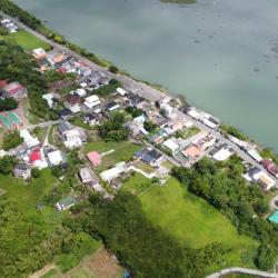
The Jing’an Hamlet is located on the south bank of the Xiuguluan River’s estuary in Fengbin Township, Hualien County. Due to its flat terrain, it is on the same straight line as Jingpu Hamlet. The traditional name, Tisilan, is derived from the Amis word “Saadisi”, which means on a straight line. At the end of the Qing period, due to the Cepo’ incident, the Qing soldiers originally stationed in Dabei moved here and renamed it Dagangkou Camp. Later, the Han people moved in, and the place is known as Da Pian Yuan. It was not until the post-war period, when house number plates were issued, that the place was renamed to Jing’an. In the 1980s, due to the increased population, Jing’an hamlet gradually got separated from the bigger Jingpu hamlet. At present, the Jing'an hamlet is mainly concentrated by Han people on both sides of the provincial highway 11.