Antong Traversing

Danman
胆曼部落空拍一景

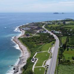
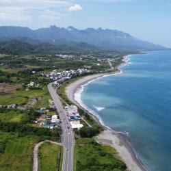
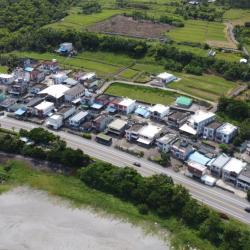
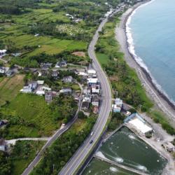
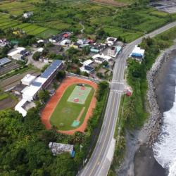
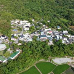
Danman, an Amis tribe, is located on the south coast of Wushibi. There were sayings that its ancestors migrated southward in the 12th year of Guangxu (1886) because they could not bear the oppression of the high mountains in the north of Hualien Port Office, or because of the small cultivated land, or because they were defeated in the battle with the Qing soldiers. 

When their ancestors arrived here, it was a dark night so they named the settlement tonman, which means night in Amis language. This was translated into Danman-she in Chinese. There is another theory that there is a deep ditch at the southern end of the settlement. The bottom of the ditch is covered with thatch, and it looks dark even during the daytime. “Dark” in the Amis language is toman or ta'man, so ta'man is the name of the settlement. Around the 34th to 35th year of Meiji (1901-1900), the tribe moved south from the Dingzailuoshe (Dingziloushe, Pacidal) of the Hualien Harbor Office in search of arable land. At the beginning, they lived with the Wushibishe in present-day Nanwu. In the foothill area above the Danman Bridge on the west side of the stone nose, people moved down to live on the coast in the early days of the Japanese occupation, and moved to the current site when the coastal highway was built.

Yushui Bridge Hamlet
玉水橋空拍一景

This image shows the coastline around Yushui Bridge from north to south. The small settlement in the middle is Yushui Bridge hamlet, and the promontory on the upper right protruding out of the sea is Sanxiantai. The Yushui Bridg Hamlet is located about 700 meters south of Shiyusan. It belongs to Zhongxiaoli, Chenggong Town. Because it is located on the south side of Yushuiqiao, it is named Yushuiqiao. It is an Amis settlement formed after the war. The Amis call this place fadoachan or larachan, which is formed by the Amis who moved from Dulan and Jialulan in Donghe Township, Danman in Changbin Township, Guanshan Township, and Chong'an and Jiaping in Chenggong Township after the war. The fairly new settlement currently has about 36 households, all of which are Amis except for two Han households. Although this settlement has a short history and a small population, it has held harvest festivals every year in recent years.

Yiwan Chapel - Taiwan Presbyterian Chapel
台灣基督教長老教會大門入口

The Taiwan Presbyterian Church was introduced to the Yiwan hamlet in 1950. Zhu Lanmei and others were converted from other religions. At that time, preacher Chen Zhifeng and Pastor Lin Chuanming also assisted the church in evangelizing. Due to the increasing number of believers, the believers built the chapel and completed construction in June 1953. In June 1974, the original church was destroyed by a typhoon. Designed by Lai Mingde, a member of the clan, the believers worked together to build a new church. The front of the church was built in the form of a small European country chapel. The white exterior wall is the main visual base, and the roof has the style of Gothic architecture. And there are cross and angel carvings on the tip of the roof and on both sides of the gate. Its shape is like a small European church as seen on Christmas cards, so it is called a “geeting card church”. In 2003, it was designated as a "Historic Building" by the Taitung County Government.


South Wushibi
南烏石鼻部落空拍一景

The Provincial Highway 11 passes through the settlements on the east coast. From the picture, the nearest small settlement is South Wushibi, the middle is North Wushibi, and the farthest is Ningpu, Guangrong and other places. South Wushibi is located by the submergent coastline on the north side of Wushibi, backed by mountains and faces the sea. It is symmetrical with North Wushibi and named South Wushibi, and belongs to the 14th alley of Ningpu Village. There are only about 10 households in the settlement, including familynames of Zhong and Xie from Pingtung, Huang from Changhua, and Pan from Yilan. The Kebalan people moved here after the "87 Flood" in 1959. Residents make a living by fishing with most catches being snapper and lobster, which are mainly supplied to local seafood restaurants. If they catch large fish, they will be sent to Chenggong Fishing Port for auction.

North Wushibi
從空拍機望向北烏石鼻部落空拍一景

The Provincial Highway 11 passes through North Wushibi Settlement, an Amis tribe located between Ningpu and South Wushibi. North Wushibi is located on the south side of the Ningpu Creek mouth. It is the "Wushibi Community" of the Amis people, and is called ciradayai in Amis. Radai in Amis means orange jasmine (commonly known as Qilixiang). It was named after this tree because there were many growing nearby. In the past, Amis men, women and children used the radai for their teeth as there is a custom of burning charcoal to blacken teeth. The Han people named it "Wushibi" (black rock nose) because there is a black rock promontory protruding out of the sea in the southeast of the settlement that looks like a human nose protruding outwards. The ancestors of the Wushibi community moved from the Hualien Port Office Ganana community at the end of the Qing Dynasty. At the beginning, they lived with the people of "Danman-she" in the foothill area above the Danman Bridge on the west side of Nanwushibi community. The settlement was only moved to the current site during the Japanese occupation .

Xiakan
空拍下崁社區,下崁為阿美族南竹湖部落之一部分。

The area around ​​Luliaogou above the hillside on the west side of Zhuhu is known as Zhuhu community. The Luliaogou area was originally the site of the Zhuhu-she and the Sabie-she of the Amis people. In the late Qing Dynasty, due to a land dispute with the local Pingpu peoples that almost turned into a fight, the Pingpu peoples cursed that there were ghosts in the area and will cause disasters. The Amis people were deeply afraid of the theory that ghosts would disturb the people, so they migrated to the south and north of the area one after another. Among them, the one going south is today's Nanzhuhu, and the one moving north is the left bank of Dade River. The Ami people of Nanzhuhu called the community bakaraatsu (the name of a kind of crab) because the early Zhuhu-she was surrounded by paddy fields, and there was a small crab called bakaraatsu inhabiting the paddy fields. After the war, due to the division of the tribe, it was divided into upper and lower communities. The upper "Nanzhuhu" is adjacent to alley 17-20 of  Zhuhu hamlet 17-20, and residents are mainly Catholic and Presbyterian. The lower part, also called "Xiakan", is alley 15-16 of Zhuhu hamlet, and most of them are true Jesus believers.

Zhuhu
空拍竹湖國小一帶,此處屬於竹湖社區的一部分

Zhuhu is a settlement of the Pingpu ethnic group (other Austronesians in Taiwan), distributed along the Provincial Highway 11. This place was originally the Xiaozhuhu community of the Amis people (also called Zhuhu-she while the Amis call it Taman-she, which means "darkness" and is transliterated as "Danman-she") and the former site of Sabie-she (Amis people called it Mornos-she). The original tribe lived in the "Luliaogou" area on the hillside to the west of the current site. Later, the Amis moved to Dasaobie (now Yongfu) in the north and Nanzhuhu in the south, and the local area was inhabited by the Pingpu peoples. As the bamboo forest around the original site was luxuriant and shaped like a lake, the Han people called it the "Bamboo Lake" (Zhuhu) community. At present, there are only about 20 households in Zhuhu, and the Pingpu peoples account for about half of the population. The rest are Hakkas and Hokkien who immigrated to the nearby hills and mountains during the Japanese occupation, and moved here after World War II.

Antong Hamlet
從空拍機望向安通部落空拍一景

The original name of Antong hamlet was Hongyu or Wengsuo, which comes from the Amis word Ancoh, and means "the smell of urine". The name came about when the Amis people first moved here and the smell of sulphur is like a child’s urine. During the Qing Dynasty, the Han people came here to reclaim the land, and their phonetic translations were Wengsuo and Hongyu. Antong hamlet was first established in a place called Tailaan at the mouth of the Antong River. In the 6th year of Taisho (1917), the houses were demolished for the construction of the Eastern Railway. After the completion of the railway, the settlement was moved to the current location and renamed Antong. Most of the tribal residents are Ciwidian and Pacidal clans from Shuilian and Rarangus clan from Taitung. The origin of the tribe is different from that of the Harawan tribe, because although there is only a mountain between the two tribes, they have little contact with each other. Before the 1980s, there were often fights over land.

Chengguangao Cultural Landscape
成廣澳文化地景前的廣恆發商號遺址

Chengguang’ao Cultural Landscape Park is located in Chenggong Township, Taitung County. It was originally the site of the Guanghengfa Company. Through the existing brick arch arcade-style pavilions and columns, one could see that the gateposts, carvings and styles were rare in the eastern part of Taiwan for that time.

Guanghengfa Company was founded in around 1916. It was built from scratch by Wen Taikun, a Hakka who emigrated to Neipu, Pingtung, and was the largest grocery store in the east coast area at that time. The goods were mainly imported through the Chengguang’ao port and was said to be a large-scale business in the early period. In the mid-Japanese occupation period, Wen Taikun was already the richest man in Xingangzhuang. During World War II, it was told that the Guanghengfa Company was once regarded as a bombing target by the US military because of its prominent position.

Chengguang'ao Tianhou Temple
成廣澳天后宮是東部歷史最悠久的天后宮

Chengguang’ao Tianhou Temple is located in the Xiaogang area where the Han people first landed on the east coast in Chenggong Township, Taitung County. It was built in 1874 and is the oldest Tianhou Temple in the east. According to documentary records, Chengguang’ao Tianhou Temple was originally a hand-carved wooden structure. The Mazu statue that is enshrined in the temple was brought in from Lugang Tianhou Temple by Liu Jinlai, who was assigned to Houshan as general manager. Legend has it that the Mazu statue was once rejected by the indigenous people and the Japanese, and once lived in a stone cave by the Keelung Sea. It was only in the post-war period that it was invited back to Xiaogang for worship.