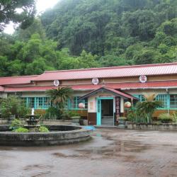
Hongye Hot Spring is located in Hongye Village, Wanrong Township. It is opposite to Ruisui Hot Spring across Hongye Stream, so it is also called Inner Hot Spring. It is about 5 kilometers away from Ruisui Station. The spring water comes from the foothills of Jiaxing Mountain. It is an alkaline hydrogen carbonate spring. The water quality is clear and transparent, colorless and odorless. The spring temperature is about 47 degrees Celsius, and the hydrogen ion concentration is 6.6. During the Japanese occupation period, a hostel was built here, and it continues to operate under the name of "Hongye Hot Spring Hostel". The old Japanese-style wooden buildings are still intact. The handwritten signboard at the entrance is very vintage. The wooden sliding doors, wooden window frames, wooden floors and tatami floors are full of Japanese style. Due to inconvenient transportation, there are few tourists, but it is far away from the hustle and bustle and the environment is very quiet.
Amis
There is a Hongye bridge on the right side of the tribe leading to the Hongye hamlet, and under the bridge is the Hongye Stream. The Xibao hamlet belongs to Hongye Village, Wanrong Township. It is located on the south bank of Hongye Stream and at the west end of Hongye Bridge. The Hongye area was inhabited by the Amis and Bunun people successively in the early days. After the 8th year of the Showa Period (1933), the Truku people moved in one after another. Most of the early tribes lived on the left bank of Hongye Stream west of Ruisui Hot Spring and the southern foothills of Hutou Mountain. A small part lived near the present Hongye Hot Spring, at the northern foot of Dijia Mountain. Because it is on the opposite bank of Hongye tribe, it is called "Xibao", which is the Truku word Sipaw, meaning the opposite side.
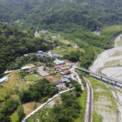
The left half of the settlement in the image belongs to Hongye Village, Wanrong Township, which is the Hongye Tribe of the Truku group, and the right half is Ruixiang Village, Ruisui Township, which is the Amis Hot Spring Tribe. Hongye Village is located on the left bank of Hongye Stream, and is adjacent to Ruisui Hot Spring in the east. In the early days of Hongye, the Amis and Bunun people lived successively. The Amis people called the area Koyo because of its many mountain cats there, namely the masked palm civet, and in the Amis language it is called Koyo. After the Japanese occupation, Koyo was translated to the japanese word koyo, which means autum leaves, and “Hongye” in chinese character. After the 8th year of the Showa era (1933), the Truku people moved in one after another. Because of the narrow terrain and lush vegetation, the Truku language called it Utux Qrunang, which was later transliterated as "Wudof Kelonan". This was later shortened to "Aifunan", which is the name of the place that the people use today.
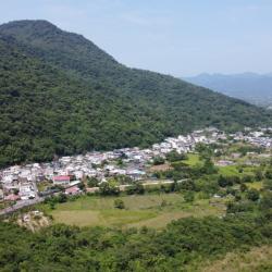
The form of tobacco barn can be divided into two styles: Osaka style and Hiroshima style. The smoke outlet of the Osaka-style tobacco building protrudes from the roof. It is tall, large, and the smoke exhaust effect is good. The curing time is short, but the quality of the cured tobacco leaves is poor, and because of the large wind surface, it is easy to be caught in a typhoon. blow bad. The Hiroshima-style tobacco building is just the opposite. The smoke exhaust port is located on the slope of the roof, and the smoke output is small, so the curing time is longer, so the quality of the tobacco is better. Although it is less afraid of typhoons, it is prone to fire. During the Japanese colonial period in Ruixiang Village, Japanese tobacco farmers came here to plant tobacco. At the beginning, most of them recruited local Amis people as tobacco workers. After the war, this area was designated as a professional tobacco production area. It has become the most important industry for residents, and there were dozens of tobacco buildings. Today, there are only 14 Japanese Osaka-style tobacco buildings preserved in the village, which is the area with the most preserved tobacco buildings in Ruisui Township.
The sea ritual plaza of the Gangkou tribe is the place where the Amis people hold fishing sacrifices. The Amis people believe that their ancestors came across the sea, so they hold sea sacrifices to thank the god of the sea for protecting their ancestors to land. Different regions has different name for the fishing festival. It is called Milalikis by the northern Nanshi Amis, and Misacepo' by the Coastal Amis. Different regions also hold the festival at different times although it is held before the harvest festival, roughly from June to August. The fishing festival is a concrete manifestation of the Amis people's gratitude to the gods of the sea and the gods of heaven and earth. They believe that the natural world is dominated by many gods. They respect nature and hope to catch abundant fish and shrimp every year. The biggest taboo in the sea festival activities of the Gangkou hamlet is that women are not allowed to participate in the ritual. They believe that if women participate, there will be no catch for the year.
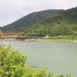
The New Changhong Bridge is a red arch bridge spanning both sides of the Xiuguluan River estuary. It is an important bridge connecting the Jingpu hamlet and the Dagang hamlet. There is a boat dock below the bridge, and at the south end of the bridge is the Xibulan Visitor Center. Next to the new Changhong Bridge is the old Changhong Bridge. The old bridge was completed in May 1968. It is 120 meters long and was the first cantilever single-arch concrete bridge in Taiwan. Due to the long term traffic use of the bridge, it became a bridge for pedestrians when the new bridges was completed and opened to traffic in January 2013. The magnificent new bridge can be seen from the old bridge. The new Changhong Bridge is 185 meters long, has eight semi-circular viewing platforms on the bridge, where you can overlook the boats passing underneath, as well as the beautiful scenery of Xiuguluan River estuary and Ci’poran Island.
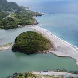
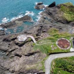
Ci’poran Island is located at the estuary of Xiuguluan River. In Amis language it is called cipo or ci’poran, which means island in the river. In the 8th year of Jiaqing (1803), Japanese fisherman and others drifted here and named the place ciporan. It was later changed to "Luoge Island", which means hunched or hunchback. In the 4th year of Emperor Guangxu of the Qing Dynasty (1878), the "Map of Mountains Before and After Taiwan" named the lace Lion Ball Mountain, and later Lion Ball Island. The Japanese called it Bantian Island. According to the Gangkou Amis legend, this place is where their ancestors first settled in Taiwan, and therefore, it is an important ritual site for them to hold sea rituals. There is a prehistoric culture on the island, where there are still some stone tools and Amis-style pottery fragments left on the surface. The highest altitude on the island is about 40 meters, and the island covers an area of about 10 hectares. On the north and south sides of the island, under the combined action of rivers, waves and tides, many gravels are deposited at the estuary to form natural embankments whose shapes change with the seasons. Ci’poran Island is now listed as a nature reserve and cannot enter without an application.
Sanfu Bridge Hamlet is located in Jingpu Village, Fengbin Township, Hualien County. It is an Amis hamlet close to the Pacific Ocean. In the native language it is called Sahfongan, which refers to low-lying sandy land. It is located about 1.5 kilometers south of the Jingpu hamlet. This place was originally the arable land of the Jingpu (Cawi) hamlet, where people began to migrate from the Jingpu to here in 1954. After the 1980s, many people separated from Jingpu, and gradually formed a new settlement, named Sahfongan. There are currently about 30 households. Between July to September 1959, there were 4 strong typhoons. In the same year, Jingpu School was established in Sanfuqiao hamlet, and later moved to its current location in Jing'an.
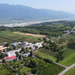
Wuhe Terrace in Ruisui Township, Hualien County, is located southwest of the confluence of Xiuguluan River and Hongye River. The cultivation began during the Japanese occupation, when Japanese companies established the Hualien Port Coffee Farm here and recruited Taiwanese immigrants to grow coffee. Hakka immigrants from the Taoyuan, Hsinzu and Miaoli area are the mainstays. Workers’ accommodations were built in the area of Saobading and gradually a small settlement was formed. Unfortunately, the originally planned tea colonization plan could not be successfully carried out due to the outbreak of the Pacific War. Until the post-war period, the National Government began to promote tea cultivation on the Wuhe Terrace. In its heyday, the tea plantation once covered 300 hectares and became the main tea-producing area in the east. The look of the tea village has been maintained to this day.
The Saoba Stone Pillar site is located on the Wuhe platform that is surrounded by Xiuguluan River and Hongye River in Wuhe Village, Ruisui Township, Hualien County. It belongs to a branch of the Puyuma Culture of the Neolithic Age. There are two slabs on the site, one tall and one short. The taller stone pillar is about 6.7 meters tall. The pillars were discovered in 1925 by Koizumi Tetsu, a reporter who worked for the Asahi Shimbun in Osaka during the Japanese occupation. Four years later, the Government-General in Taiwan launched the first investigation of the site. There are rich myths and legends of the Saoba Stone Pillars to the people of the Chimei Hamlet. The pillars are important sacred symbols for Amis people and the founding of the Chimei community and the establishment of Chimei Hamlet.