Amis

Ruiliang
瑞良村的中山路沿線為人口集中之處

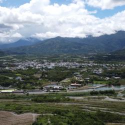
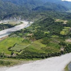
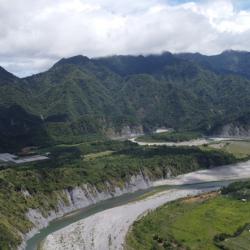
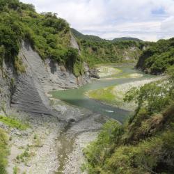
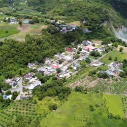
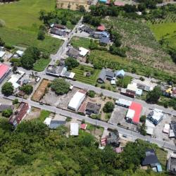
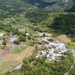
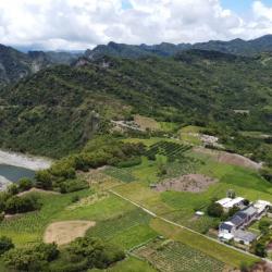
Ruiliang Village, in Ruisui Township, Hualien County, sits on the west bank of the confluence of Malangou Creek, Hongye Creek and Xiuguluan Creek. It is a flat sedimentary plain.

During the Qing period, the Feihu Army once camped here, and called it the Shuiwei Camp. Under the changes of policies from excavating mountains and managing indigenes to militia settlement, this place became Shuiwei village, which is the present Ruiliang village. Due to the tobacco industry immigration plan during the Japanese occupation, many immigrants began to move into Ruisui Village. In addition to planting tobacco leaves, sugarcane was still dominantly cultivated in the Linxi area. In the beginning of the post-war period, the southern part of the immigrant village was separated, and the new Ruiliang Village was established.


Ruisui
從遠處眺望瑞穗聚落

The formation of settlements in Ruisui Township, Hualien County, began during the Japanese occupation, when free immigration was encouraged. In 1926, Japanese tobacco farmers arrived in Ruibei Village to promote tobacco leaf cultivation. Government-run immigrants from other areas in the Karenko Prefecture (now Hualien County) were successively moved here to establish immigrant settlements specializing in tobacco leaf production. In the post-war period, the National Government re-divided the Ruisui Immigrant Village into four villages. At that time, the industry was still tobacco growing. However, in the 1980s, the tourism and boating industry on the Xiuguluan River emerged, which drove a rapid growth of the local economy. Most of the residential buildings have been converted into modern reinforced concrete buildings.

Dewu River Terrace
從遠處眺望德武河階

Dewu River Terrace is located on the east side of the confluence of Xiuguluan River and Fuyuan River in Ruisui Township, Hualien County. It is the starting point where Xiuguluan River cuts through the coastal mountains. 

The traditional name is Lulnu, which means paper mulberry because in the past, there were many wild paper mulberry trees here. It is also an area where the Amis people do dry farming and grazing. Overlooking from the Ruigang Industry Road, it is clear that the Dewu River Terrace descends from south to north. This shows that the river is continuously migrating to the north during the downward cutting process, which results in asymmetric growth meanders on both sides of the river bank. In addition, there is a prehistoric cultural site on the hillside of the Dewu River Terrace as fragments of plain pottery from the Jingpu hamlet have been found. This presumes that this was where the Amis people lived in the early days.


Houzi Shan (Monkey Mountain)
從瑞港公路眺望猴子山

Houzishan (Monkey Mountain) is a river terrace along the Xiuguluan River that is located on the east side of the Dewu river terrace in Ruisui Township, Hualien County. Its traditional name is Kawasan, which means a place where gods and ghosts appear. Therefore, it is also called Ghost Mountain. It is said that macaques came here to forage in the past. Xiuguluan River is the largest river in eastern Taiwan, with a total length of about 104 km. In the process of cutting through the coastal mountains, many steep canyons have also been formed, resulting in developed meanders and river terraces, such as Dewu River Terrace, Monkey Mountain, and Chimei River Terrace. This makes an excellent classroom for observing geology or topography.

Xiuguluan River
從奇美部落往西眺望秀姑巒溪,右下為奇美河階

The Xiuguluan River begins from the Central Mountain Range. It runs north along the Huadong Rift Valley, and turns eastward at Ruisui Township in Hualien County. Then it cuts across the coastal mountains and finally flows into the Pacific Ocean at Dagangkou (Cepo’) Hamlet. It is the largest river in eastern Taiwan with a total length of about 104 km. Also, it is the only river in Taiwan that cuts through the coastal mountains. During the process of cutting through the coastal mountains, the Xiuguluan River also cuts many steep gorges, resulting in some quite developed meander and river terraces, such as Dewu River Terrace, Monkey Mountain, and Chimei River Terrace. This makes an excellent classroom for observing geology or topography.

Chimei (Kiwit) River Terrace
奇美河階西側的地層結構,奇美部落即位於此河階面上

Chimei River Terrace of Ruisui Township, Hualien County, is located at the confluence of the Xiuguluan River and Chimei River. The single-sided mountains, circulation mounds and river terraces in this area are quite developed, and the Chimei Hamlet is located on the platform of this river terrace. Chimei River was originally a turbid current that entered the sea. But during the uplift of the coastal mountains, it continued to erode toward the source, which changed its course and converged into the current Xiuguluan River. In addition, the Chimei Fault is the most important active fault in the coastal mountains, with a total length of more than 30 km. The stratigraphic structure of the Chimei River on the west can be seen from Ruigang Industry Road.

Chimei (Kiwit) Hamlet
從空中俯瞰奇美部落,部落集中區域為下部落

The Chimei Hamlet is located on the highlands formed by the alluvial river terraces of the Xiuguluan River in Ruisui Township, Hualien County. It is divided into upper and lower hamlets. The upper hamlet was where the tribe first established, while the lower hamlet is where the residents currently live. The traditional name of the Chimei Hamlet is Kiwit, which means crabgrass, because according to legend, there was abundant crabgrass here. However, the Han people pronounced it as Chimi. Until the Japanese occupation, the Government-General in Taiwan ordered the residents to move from the upper terrace to the lower terrace and renamed it to Chimei. 

In the past, tribal people only used hunting roads or going down the stream to get to the outside world. In the Qing period, General Wu Guangliang built plank roads, which continued to be used during the Japanese occupation. Finally, in 1986, the plank road was widened and built into Ruigang Industry Road.

Lower Chimei (Kiwit) Hamlet
從空中俯瞰奇美下部落,派出所也位於此處

The Chimei Hamlet is located in the highlands formed by the alluvial river terraces of the Xiuguluan River in Ruisui Township, Hualien County. It is divided into upper and lower hamlets. The lower hamlet is where the police station is located, and where Chimei residents currently live. The traditional name of the hamlet is Lanar, which means below, as it is located at the lower level of the Chimei terrace.  Although the terrain is flat, the bottom is mostly sand and gravel. During the Japanese occupation, the Government-General in Taiwan ordered the residents to move from the upper terrace to the lower terrace due to insufficient water sources.


Upper Chimei (Kiwit) Hamlet
從空中俯瞰奇美上部落,學校附近是舊部落位置

The Chimei Hamlet is located on the highlands formed by the alluvial river terraces of the Xiuguluan River in Ruisui Township, Hualien County. It is divided into upper and lower hamlets. The Upper Chimei Hamlet is located on the east side of the current Chimei Elementary School. It is about 100 meters above sea level and was where the hamlet first established. The traditional name of the place is Lingpawan, which means above. During the Japanese occupation, the people living in the Upper Chimei Hamlet migrated to the lower terraces. At present, about 20 households still live in the upper hamlet, though most of them are recent immigrants, including Bunun, Amis and Han people.

Upper Chimei (Kiwit) Terrace
從空中俯瞰奇美上臺地,左上可見瑞港公路橫越

The Upper Chimei Terrace is located on the highland south of the river terrace formed by the alluvial Xiuguluan River in Ruisui Township, Hualien County. It is the main location of the Chimei hamlet. A large number of cultural relic pottery of the Jingpu hamlet have been found behind the present Chimei Elementary School. Hence, the site is presumably the Nalomann hamlet, where the ancestors lived.

The traditional name of the place is Kiwit, which means crabgrass because according to legend, crabgrass was abundant here. However, the Han people misinterpreted Kiwit as Chi-mi, which means a peculiar and mysterious place. In the Japanese Occupation period, the place was renamed to Chimei.

In the past, tribal people only used hunting roads or going down the stream to get to the outside world. In the Qing period, General Wu Guangliang built plank roads, which continued to be used during the Japanese occupation. Finally, in 1986, the plank road was widened and built into Ruigang Industry Road (also known as Hualien County Road 64).