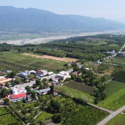
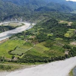
Wuhe Terrace in Ruisui Township, Hualien County, is located southwest of the confluence of Xiuguluan River and Hongye River. The cultivation began during the Japanese occupation, when Japanese companies established the Hualien Port Coffee Farm here and recruited Taiwanese immigrants to grow coffee. Hakka immigrants from the Taoyuan, Hsinzu and Miaoli area are the mainstays. Workers’ accommodations were built in the area of Saobading and gradually a small settlement was formed. Unfortunately, the originally planned tea colonization plan could not be successfully carried out due to the outbreak of the Pacific War. Until the post-war period, the National Government began to promote tea cultivation on the Wuhe Terrace. In its heyday, the tea plantation once covered 300 hectares and became the main tea-producing area in the east. The look of the tea village has been maintained to this day.
Chimei
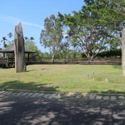
The Saoba Stone Pillar site is located on the Wuhe platform that is surrounded by Xiuguluan River and Hongye River in Wuhe Village, Ruisui Township, Hualien County. It belongs to a branch of the Puyuma Culture of the Neolithic Age. There are two slabs on the site, one tall and one short. The taller stone pillar is about 6.7 meters tall. The pillars were discovered in 1925 by Koizumi Tetsu, a reporter who worked for the Asahi Shimbun in Osaka during the Japanese occupation. Four years later, the Government-General in Taiwan launched the first investigation of the site. There are rich myths and legends of the Saoba Stone Pillars to the people of the Chimei Hamlet. The pillars are important sacred symbols for Amis people and the founding of the Chimei community and the establishment of Chimei Hamlet.
Ruiliang Village, in Ruisui Township, Hualien County, sits on the west bank of the confluence of Malangou Creek, Hongye Creek and Xiuguluan Creek. It is a flat sedimentary plain.
During the Qing period, the Feihu Army once camped here, and called it the Shuiwei Camp. Under the changes of policies from excavating mountains and managing indigenes to militia settlement, this place became Shuiwei village, which is the present Ruiliang village. Due to the tobacco industry immigration plan during the Japanese occupation, many immigrants began to move into Ruisui Village. In addition to planting tobacco leaves, sugarcane was still dominantly cultivated in the Linxi area. In the beginning of the post-war period, the southern part of the immigrant village was separated, and the new Ruiliang Village was established.
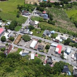
The formation of settlements in Ruisui Township, Hualien County, began during the Japanese occupation, when free immigration was encouraged. In 1926, Japanese tobacco farmers arrived in Ruibei Village to promote tobacco leaf cultivation. Government-run immigrants from other areas in the Karenko Prefecture (now Hualien County) were successively moved here to establish immigrant settlements specializing in tobacco leaf production. In the post-war period, the National Government re-divided the Ruisui Immigrant Village into four villages. At that time, the industry was still tobacco growing. However, in the 1980s, the tourism and boating industry on the Xiuguluan River emerged, which drove a rapid growth of the local economy. Most of the residential buildings have been converted into modern reinforced concrete buildings.
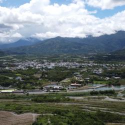
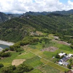
Dewu River Terrace is located on the east side of the confluence of Xiuguluan River and Fuyuan River in Ruisui Township, Hualien County. It is the starting point where Xiuguluan River cuts through the coastal mountains.
The traditional name is Lulnu, which means paper mulberry because in the past, there were many wild paper mulberry trees here. It is also an area where the Amis people do dry farming and grazing. Overlooking from the Ruigang Industry Road, it is clear that the Dewu River Terrace descends from south to north. This shows that the river is continuously migrating to the north during the downward cutting process, which results in asymmetric growth meanders on both sides of the river bank. In addition, there is a prehistoric cultural site on the hillside of the Dewu River Terrace as fragments of plain pottery from the Jingpu hamlet have been found. This presumes that this was where the Amis people lived in the early days.
The Chimei Hamlet is located in the highlands formed by the alluvial river terraces of the Xiuguluan River in Ruisui Township, Hualien County. It is divided into upper and lower hamlets. The lower hamlet is where the police station is located, and where Chimei residents currently live. The traditional name of the hamlet is Lanar, which means below, as it is located at the lower level of the Chimei terrace. Although the terrain is flat, the bottom is mostly sand and gravel. During the Japanese occupation, the Government-General in Taiwan ordered the residents to move from the upper terrace to the lower terrace due to insufficient water sources.
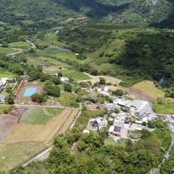
The Chimei Hamlet is located on the highlands formed by the alluvial river terraces of the Xiuguluan River in Ruisui Township, Hualien County. It is divided into upper and lower hamlets. The Upper Chimei Hamlet is located on the east side of the current Chimei Elementary School. It is about 100 meters above sea level and was where the hamlet first established. The traditional name of the place is Lingpawan, which means above. During the Japanese occupation, the people living in the Upper Chimei Hamlet migrated to the lower terraces. At present, about 20 households still live in the upper hamlet, though most of them are recent immigrants, including Bunun, Amis and Han people.
The Upper Chimei Terrace is located on the highland south of the river terrace formed by the alluvial Xiuguluan River in Ruisui Township, Hualien County. It is the main location of the Chimei hamlet. A large number of cultural relic pottery of the Jingpu hamlet have been found behind the present Chimei Elementary School. Hence, the site is presumably the Nalomann hamlet, where the ancestors lived.
The traditional name of the place is Kiwit, which means crabgrass because according to legend, crabgrass was abundant here. However, the Han people misinterpreted Kiwit as Chi-mi, which means a peculiar and mysterious place. In the Japanese Occupation period, the place was renamed to Chimei.
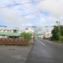
In the past, tribal people only used hunting roads or going down the stream to get to the outside world. In the Qing period, General Wu Guangliang built plank roads, which continued to be used during the Japanese occupation. Finally, in 1986, the plank road was widened and built into Ruigang Industry Road (also known as Hualien County Road 64).