Jinshuiying Historic Trail
Jinshuiying Historic Trail, which crosses Chunri Township in Pingtung County and Dawu Township in Taitung County, was excavated in 1885. Stretching around 64 kilometers from Shuidiliao to Dawu, and with an altitude of 1,000 meters, Jinshuiying Historic Trial was an important passage for moving between east and west at that time. It is said that the Pingpu tribe once used this trail to migrate to the eastern region. Due to its low altitude and short distance, the trail was used by the Government-General of Taiwan to connect east and west telecommunication networks during the Japanese occupation. After the "Southern Tribe Incident '' (or Jingshuiying Incident) that occurred in 1914, the trail was suspended until full restoration of the entire Jingshuiying Historic Trail was completed in 1917. At the same time, the Dashulin Police Post and the Gulibabaunua Police Post were built.
- / - - - - - - - /- -
Jinshuiying Historic Trail
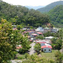
Birds’ eye view of old Lili Village
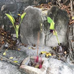
The leading stone stele placed under the tree next to Sancongrong Temple.
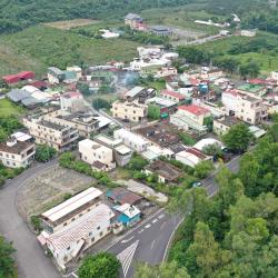
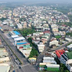
Birds’ eye view of Shuidiliao Village. The road on the left is Taiwan Provincial Highway 1.
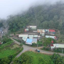
Little Lili Hamlet, situated 11.5km of Dahan Forest Road.
Wine bottles from recent times found at the site of Sidi Camp
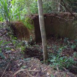
Ruins of post-war afforestation nursery
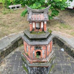
The design of the Shitou Camp Miracle Pavilion is unique and is recorded as county’s cultural heritage.
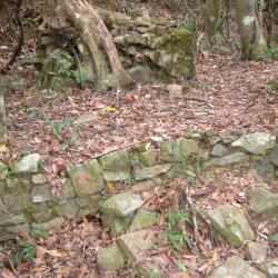
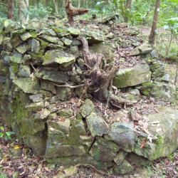
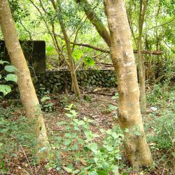
Stone fence of Sidi Camp ruins
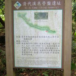
Information board of Sidi Camp Site
Stone fence of Chushui Hill police station.
Stones standing along the shoulder of ancient road from the Qing period (now: Chushui Hill slope)
Researchers taking a picture at the entrance of Gulibabaonor Police Box.
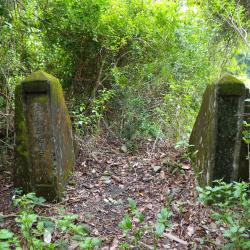
Base of the flag stand in front of the Chshui Hill police station
Concrete foundation of Chushui Hill police station
Unknown octagonal hole on the foundation of Chushui Hill police station.
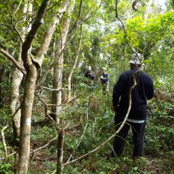
Research team measuring the area of the police station.
“Do not climb” signage outside the ruins of Jinshuiying police station.
Foundation of Jingshuiying police station that remains from the past.
Stone fence behind the Jinshuiying police station.
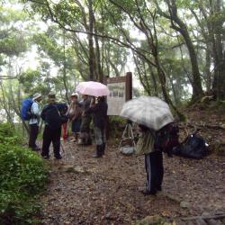
Research team taking measurement and photographs at the Prefectural Boundary information board.
Information board of Jinshuiying police station and stone fence behind it.
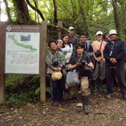
Researchers taking a picture by the information board in front of Jingshuiying Police Box.
Taiwan Anthropoligist, Pan Yinghai, taking a picture by the information board in front of Jingshuiying Police Box
點選可切換成前面的照片 點選可切換成後面的照片
Attractions
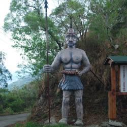
Entrance of old Lili Hamlet
Entrance of old Lili Hamlet資訊
After passing through the small Lili hamlet on the Dahan Forest Road it goes downhill slightly and soon you can see a tall statue of the Paiwan Warrior on the right. This is the entrance of the old Lili hamlet and an important intersection for the Paiwan people in the past. Standing on the ridge line, there is the industrial road leading to the old Lili hamlet in the north, and to the ruins of Guhuashe in the south. The old Lili hamlet is divided into two tribes. The bigger tribe in the north is called Kinajian, while the smaller tribe in the south is called Contres. Lili hamlet and Guhua hamlet were allies, and often joined forces to fight against foreign rulers of the Dutch, Qing, or Japanese eras. How many times they were conquered, killed, and their villages burned, they never changed their firm belief and the idea of independence.
Chushuipuo Shrine
Chushuipuo Shrine資訊
The Chushuipo Shrine is located west of Chushuipuo police post. There are stone steps on the side of the road, and along the steps, about 100 meters away are the remains of the shrine. Its foundation is about 4.7 meters square, about 0.6 meters high, and there are three stone steps of 0.8 wide in the front. In the center is the base of the shrine, which is 1.3 meters square and 0.5 meters high. The torii that once stood on both sides of the steps have decayed, and only two pillar holes remain.
Charcoal Kiln Ruins
Charcoal Kiln Ruins資訊
According to Yang Nanjun’s investigation, the Forestry Bureau has contracted locals to make charcoal from miscellaneous wood since 1959. Therefore, in the 1960s, there were many charcoal kilns on the Jianshuiying Historic Trail. At present, there is a ruin of a charcoal kiln below the historic trail located 550 meters north of the eastern edge of Chushuipuo mountain. The kiln is a circular structure with a diameter of about 4.8 meters, a rammed earth wall height of 2.1 meters, and a thickness of 0.8 meters. There is a kiln door and a small window hole for checking charcoal firing. After the charcoal kiln is filled with wood, the top and the kiln door are covered and sealed with clay. The rammed earth wall around the charcoal kiln is hardened due to high temperature.
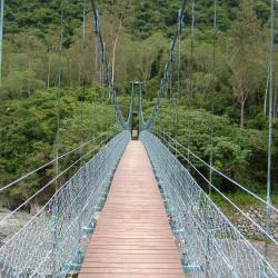
Guzilun Suspension Bridge Ruins
Guzilun Suspension Bridge Ruins資訊
The Guzilun suspension bridge is erected on the Chachayadun River, and was one of the important suspension bridges on the Jingshuiying Trail. The bridge was erected in the 6th year of Taisho (1917). At that time, the Guzilun police post was located on the north bank of the Xidi camp site (Miaopu) of the Qing Dynasty, so the suspension bridge was called the Guzilun Bridge. In the 7th and 8th years of Taisho (1918 and 1919), the suspension bridge was damaged twice by typhoons. In the 14th year of Taisho (1925), the suspension bridge was re-erected. The remnants of the suspension bridge seen today were rebuilt in the 15th year of Taisho (1926). Today, only the cement bridge girder remains intact. Around the bridge girder, the iron wires used for the suspension bridge at that time can still be found. On the bridge girder, there are engravings of the words “Completed in March 15th year of Taiso”.
Chachaya River
Chachaya River資訊
The Guzilun suspension bridge that was used to cross Chachayadun River during the Japanese rule was erected in the 6th year of Taiso (1917). At that time, the Guzilun police post was located on the north bank of the Xidi campsite (Miaopu) of the Qing Dynasty, so the suspension bridge was called the Guzilun Bridge. In the 7th and 8th years of Taisho (1918 and 1919), the suspension bridge was damaged twice by typhoons. In the 14th year of Taisho (1925), the suspension bridge was re-erected. The remnants of the suspension bridge seen today were rebuilt in the 15th year of Taisho (1926). Today, only the cement bridge girder remains intact. When the Forestry Bureau set up the national trail here, an iron suspension bridge was erected for the use and safety of visitors.
Jialaban Hamlet
Jialaban Hamlet資訊
Jialaban hamlet, or qaljapang in the Paiwan language, is located on the river terrace next to the confluence of the Jialaban River and the Dawu River. The residents were mainly from the old Jialuoban settlement, and some were from the original Chachayadun settlement. When heading west from Dawu into the Jingshuiying Trail, Jialuoban is the last settlement. In the 1970s, the residents of Jialuoban used to grow citronella. At that time, the essential oil of citronella was exported, and the income was good. With the improvement of economic conditions, the residents rebuilt their houses. Therefore, almost all the residents of Jialuoban now live in brick houses. Presently, residents grow watermelons and gourds on sandy lands by Dawu and Jialaban Rivers.
Qijia Hamlet
Qijia Hamlet資訊
Qijia hamlet, or Tjuvecekadan in the Paiwan language, has the meaning "central", because old Qijia hamlet is located between Gulou hamlet and Lili hamlet, and is in the middle of surrounding mountains and rivers. The origin of this tribe came from the padain (old Gaoyan) in the north, and then migrated to kaviangan. Later, the ancestor simerangan (the curimudjuq family) led the tribe to karuvuan (old Guichong). On one hunting occasion, when the people arrived at old Qijia the hunting dogs refused to leave. Thus, they settled down in Tjuvecekadan (Old Qijia) for at least 400 years. It was until 1961, the government moved the old Qijia to Tjukarangan in order to promote the housing improvement plan for the indigenes. In 1972, due to the severe damage caused by Typhoon Rita, the Tjukarangan (Qijia hamlet then) and other hamlets such as Guichong and Lili moved to the current location of Tjuadresir (Jialiliao), and they are collectively called Qijia Community.
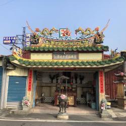
The Temple of the Loyal and Martyrs Fifteen Lords
The Temple of the Loyal and Martyrs Fifteen Lords資訊
The Temple of the Loyal and Martyrs Fifteen Lords is located next to the Shuidiliao Night Market. In the 12th year of Qing Daoguang (1832), due to the tense relationship between Fujian and Hakka, Cantonese Xu Cheng, Zhang Bing and others led a crowd to besiege the Fujian villages. Many Fujian fled. When fighting against Hakka attacks, Huang Rongyuan and other 17 Hokkien martial artists from Hengchun happened to pass by. 15 people were killed in the battle because they helped the Fujian villages. After the incident, local people in Shuidiliao built temples for them in order to thank the 15 people who sacrificed their lives to help the villagers.
Kantouying
Kantouying資訊
The Kantouying ruins, located in Xinkai Village, Fangliao Township, Pingtung County, was the starting point of the Jinshuiying Historic Trail during the Japanese occupation period. It was built on March 29, 1907. To this day, there is still a stone-built barracks from the Qing Dynasty period in the ruins, which is currently used as a warehouse. Part of the original appearance of the barracks can still be seen from the stone foundation. During the Japanese occupation, the Kantou Police Post was set up at the former site of Kantouying as entry was regulated. Due to private renting on the former site today, the Forestry Bureau changed the starting point for Jinshuiying National Trail to enter from Xinkai nursery garden, and set up an information board.
Prefectural Boundary
Prefectural Boundary資訊
The prefectural boundary between Kaohsiung State (now Kaohsiung City) and Taito Prefecture (now Taitung County) during the Japanese occupation is located 2.6km away from the sign for Jinshuiying National Trail. It is also the tip of the terrain slope because it is uphill from the entry on Dahan Forest Road to the boundary, then it goes all the way downhill. According to the Forestry Bureau information board, when the Governor-General in Taiwan patrolled Jinshuiying Trail from Taito Prefecture during the Japanese occupation, the Officials of Kaohsiung State would greet him at the boundary. Moreover, due to the fog and rain all year round and the landscape of the terrain the trail accumulates water easily. Hence the name ‘Jinshuiying’, which means Soaking Camp.
Jingshuiying Police Post
Jingshuiying Police Post資訊
According to Yang Nanjun, an expert on ancient road research in Taiwan, the place was called Jinshuiying (literally Soaking Camp) because of the fog all year round, abundant rainfall, and the terrain that is prone to accumulate water. Before it got its name in 1894, the camp was called Dashulinying, which was set up during the Qing Dynasty period. During the Japanese occupation, the Governor-General in Taiwan established the Jinshuiying Police Post in 1901 at an altitude of about 1,280 meters. It was an important base for government officials and business travelers traveling to and from the east and west. However, the police post was destroyed during the 1914 Jinshuiying incident. After multiple rebuilding, it was withdrawn in 1936.
Gulibabaunuo Police Post
Gulibabaunuo Police Post資訊
The Gulibabaonuo Police Post is located on the southeastern edge of Dahan Mountain, at an altitude of about 750 meters. It was set up in 1917 and was an important checkpoint for the Jinshuiying trail that led to the southern linking road. It is about 1.3 km away from the Chushuipuo Police Post. Due to the Jinshuiying incident in 1914, the trail was unusable for several years. The Governor-General in Taiwan sent personnel to investigate the status of indigenous peoples and restored the trail. At the same time, established the Dashulin and Gulibabaonuo Police Posts. Later in 1926, the Gulibabaonuo Police Post was abolished and a new one was re-established in Chachayadun Hamlet in the south.
Chushuipuo Police Post
Chushuipuo Police Post資訊
During the Qing period, the Chushuipuo camp was established, and 30 troops were divided into three teams. Coming to the Japanese occupation period, the Governor-General in Taiwan built the Chushuipuo Police Post on the old camp site in 1919. It is located on the southeastern edge of Mount Dahan and is at an altitude of about 700 meters. A few years later, it was relocated some distance away for reconstruction. It was the only police post on the eastern section of Jinshuiying trail at the end of the Japanese occupation, and continued to be used until after the surrender of Japan in World War II. However, since the 1960s, forestry workers have used the site as a work shed. Today, relics of daily items can be found on the site.
Ruins of Sidi Camp Site
Ruins of Sidi Camp Site資訊
After the Jinshuiying trail was opened in 1885, Xidi Camp was set up, making a resting stop for officials and business travelers who passed this trail during the Qing period. During the Japanese Occupation, the Governor-General in Taiwan set up the Guzilun Police Post here in 1916, and then a few years later moved it above the ridge. In the late 1960s, the National Government set up an afforestation nursery in Xidi Camp.
Shitou Camp Cherish Character Pavilion
Shitou Camp Cherish Character Pavilion資訊
The Shitou Camp Cherish Character Pavilion, is located in the former camp site for troops during the Quing period in Yuquan Village, Fangliao Township, Pingtung County. It was built in 1874 and was an important entrance to the Jinshuiying trail on the western side. A year after the camp was built, the then General Zhang Qi-Guan set up a school for indigenous people. A pavilion was also built to incinerate broken books or paper with written characters. This is to respect the heavens and treasure written language, hence the name “Cherish Character Pavilion”. The unique design of the pavilion shows a hexagonal base topped with a house and a horseback roof.
Today, the Shitou Camp Cherish Character Pavilion is listed as the county’s cultural heritage.
Sidi Camp Site
Sidi Camp Site資訊
Xidi Camp was established right after the Jinshuiying Historic Trail was opened in 1885. It was a resting stop for officials and business travelers who passed through this trail during the Qing period. During the Japanese Occupation, the Governor-General in Taiwan set up a Guzilun Police Post here in 1916, and then a few years later moved it above the ridge. In the late 1960s, the National Government set up an afforestation nursery in Xidi Camp.
Little Lili Village
Little Lili Village資訊
Little Lili Hamlet is located in the south-eastern saddle of Mount Lili, 11.5 km away from Dahan Forest Road, with an elevation of 1,020 meters. The Paiwan traditional name for this place is Chalalapa , and was originally uninhabited. The formation of the Little Lili Hamlet was due to the widening of the Dahan Forest Road in 1969. People from the Lili Hamlet have successively moved to settle here. Currently there are about ten households. At the foothills of Mount Lili to the west of the hamlet, and about 10 meters above Dahan Forest Road are road ruins from the Japanese occupation period.
Shuidiliao Village
Shuidiliao Village資訊
Located in Fangliao Township, Pingtung County, the Shuidiliao Village was originally a forest lowland. The Makadao people of Fangsuoshe who lived in Dawuli in the late Ming period began to hunt and cultivate here. Coming to the Qing period, Huang Maochun, the head for the Fangliao reclamation, led the people to cultivate Shuidiliao in 1711. As it was close to the mountainous area, trades with indigenous peoples were prosperous and gradually formed a market.
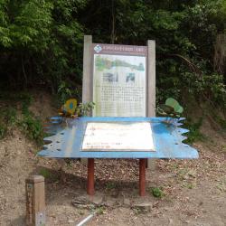
Jinshuiying Historic Trail Entrance
Jinshuiying Historic Trail Entrance資訊
Located in Shuidiliao, Fangliao Township, Pingtung County, the Sancongrong Temple is the starting point of the Jinshuiying Historic Trail during the Japanese occupation. Natural rock blocks were placed under the tree next to the temple, The rock block on the right has “leading the way” engraved on it, and Taoist amulet on the left. According to a survey conducted by Taiwan’s ancient road research expert, Yang Nanjun, the local residents called this area Rulingkou (ridge entrance).
Later in 2019, the research team got another saying from local elders that after the opening of the Jinshuiying Historic Trail at the end of the Qing period, the stone stele of “Leading the way” was a meeting point for people before entering the mountain. They said that this meeting point was protected by armed Qing soldiers and that traveling in groups was to avoid attacks by indigenous peoples. The words engraved on the stone stele reflected this.
Old Lili Village
Old Lili Village資訊
Lili Hamlet (Lalekeleke) is located on a slope in the North-eastern side of Mount Lili, between 600 and 750 meters above sea level. The hamlet was composed of the large Kinajian tribe in the north and the small Contres tribe in the south. According to the survey conducted during the Japanese occupation, the Lili Hamlet has a large population of 261 households with 1,058 residents. A police post was set up above the large tribe. Later in 1914, after the Jinshuiying incident, the Governor-General in Taiwan moved the people, mainly Paiwan tribe, to Chachayadun and Guihuamen hamlets in batches to weaken their tribal power. In the post-war period, those who were still living in Lili Hamlet were moved to Qijia in 1959.
- -/-