In 1952, Taipower built Wanshantag next to the old Qilai Tai-power hut. Originally it was called "Qilai Temple" and was to remember those who died in the line of duty in the construction of the "East-West Power Transmission Line" since 1950. In the autumn of 1953, it was opened for worship. In 1980, a road was opened for the construction of the Papaya Creek Hydropower Project. Nenggao Traversing Trail and the original Qilai Tai-power hut were abandoned. Therefore, with donations from the engineers, the temple was relocated to the current site next to the Qilai Lodge. In the past, on the autumn equinox of September 23 every year, Wanshantang would hold sacrificial activities, and the line guards and supervisors who were related to this route would attend the event in person. In recent years, the road is no longer passable, so the Huadong Power Supply District Operation Office hold the autumn equinox festival at the office.
National Trail
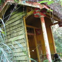
Qilai Lodge is located at 14.6K on the Qilai Tai-power maintenance road. It is also known as the maintenance center. It is a three-story building with reinforced concrete and each level has an area of around 150 square meters. Level one has a storeroom and diningroom, level two and three each has eight bedrooms, which can accommodate a total of 60 people. It is currently not open for use. Qilai Lodge was built in 1984 to accommodate transmission line maintenance personnels for maintaining the old east-west power transmission line, Taipower repaired the Nenggao Trail to use as the road for maintaining transmission lines and rebuilt the police posts that were left from the Japanese occupation into Tai-ower huts. Qilai Lodge was not rebuilt from a police post. In fact, Qilai police post is located 1 km east of Qilai lodge, near the Tianchang River. The Qilai police post was rebuilt as the Qilai Tai-power hut but was abandoned in 1980 when a road was opened for the construction of the Papaya Stream Hydropower Project.
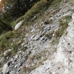
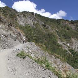
This is a section of Tai-power maintenance road near the Qilai Tai-power hut. The Nenggao Traversing Trail from the Japanese occupation period became Taipower's maintenance road after the war. In order to send the remaining hydroelectric power generation in the east to the west, which was in urgent need of electricity, so as to develop Taiwan's economy, the old east-west transmission line was built in 1950. For the maintenance of transmission lines, Taipower rebuilt the police posts left from the Japanese occupation period as a Tai-power station. There are nine spots in total, namely Wushe, Lushan, Yunhai, Tianchi, Junlin, Qilai, Panshi, Longjian and Tongmen, that provide accommodations for transmission line maintenance personnel, and storage for emergency repair equipment. Nenggao Traversing Trail became the main road for Taipower to patrol the tower. At the end of 1970, Taipower planned the "Qilai Water Diversion Project" to develop the water power of Papaya Creek, and built underground water diversion tunnels and dams in the middle and upper reaches of Papaya Creek. For the convenience of the construction and improving the maintenance road, a road for automobiles were opened from Tongmen to Qilai, and built the Tianchang Tunnel on the Tianchang Cliff. After the road was completed, there were only 27 kilometers of Nenggao Traversing Trail left from Tunyuan to Wujiabeng Mountain.
Nenggao Traversing Historic Trail route starts from Tunyuan Mountain Pass in Renai Township, Nantou County. Going east, winding around the mountainside in the south of Weishang Mountain, passing the Yunhai Tai-power Hut and Tianchi Lodge, then cross the Nengao Saddle in the south of the Nengao North Peak in the Central Mountain Range, and then all the way downhill, passing through the Guilin Tai-power hut, Wujiabeng Mountain, and down to the eastern part of Qilai Tai-power hut, and finally arriving at Tongmen Village, Xiulin Township, Hualien County.
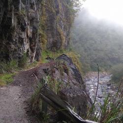
In the late 1970s, due to the erosion caused by the convergence of two rivers, the mountaisides began to collapse vigorously that left no traces of the traversing trail. Hence, the only way in was through Tai-power maintenance road, up to the top of Wujiabeng Mountain, then down to the east entry of the trail at the end of Qilai Tai-power maintenance road.
In the 6th year of Taisho (1917), the Japanese government opened up the Nenggao Traversing Trail and named it "Hatsune Qilai Crossroad", which is the old Nenggao Traversing Trail. In the 14th year of Taisho (1925), due to the high altitude of the eastern section of the old trail, snow often made it difficult to travel in winter, and the entire Traversging Trail of Hualien Harbor Hall and Nantou Hall was rebuilt, with a total mileage of 76.8 kilometers after completion.
After the war, in order to restore the power system on the island of Taiwan, the Nationalist Government built a number of towers along the Nenggao Traversing route to complete the "East-West Link Transmission Line". In 1998, after the completion of the new east-west transmission line between Mingtan and Fenglin, the old east-west line was gradually replaced until it was officially decommissioned in 2016. At present, the west section of Nenggao Traversing Trail is well maintained due to the demand for the transportation of materials from Tianchi Lodge, and passing of locomotives. The eastern section, on the other hand, has a low utilization rate after the withdrawal of Taipower personnel, and the road conditions are not as good as the western section.
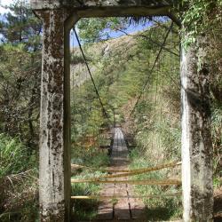
The Upper Guilin Suspension Bridge on the eastern section of Nenggao Traversing Trail is located between the Neggao Saddle and the Cypress Forest Preservation Office, with an altitude of 2,740 meters. Since the eastern section of Nenggao Trail is less used, both important suspension bridges on the way, the Upper Guilin Suspension Bridge and the Guiqi Suspension Bridge, fell into disrepair and became hazardous. In the 6th year of Taisho (1917), the Japanese government opened up the Nenggao Traversing Trail and named it "Hatsune Qilai Crossroad", which is the old Nenggao Traversing Trail. In the 14th year of Taisho (1925), due to the high altitude of the eastern section of the old trail, snow often made it difficult to travel in winter, and the entire Traversging Trail of Hualien Harbor Hall and Nantou Hall was rebuilt, with a total mileage of 76.8 kilometers after completion.
After the war, in order to restore the power system on the island of Taiwan, the Nationalist Government built a number of towers along the Nenggao Traversing route to complete the "East-West Link Transmission Line". In 1998, after the completion of the new east-west transmission line between Mingtan and Fenglin, the old east-west line was gradually replaced until it was officially decommissioned in 2016. At present, the west section of Nenggao Traversing Trail is well maintained due to the demand for the transportation of materials from Tianchi Lodge, and passing of locomotives. The eastern section, on the other hand, has a low utilization rate after the withdrawal of Taipower personnel, and the road conditions are not as good as the western section.
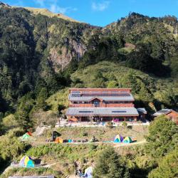
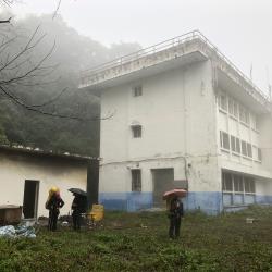
The Tianchi Lodge is located in the sheltered area of the mountain depression on the west side of Nengao North Peak, with an altitude of 2680 meters, which is the highest point of Nenggao Traversgin Historic Trail. When the trail was completed in September of the 7th year of Taisho (1918), the Nenggao Police Post was established to meet the needs of road maintenance and mail delivery. It was burned down in the Wushe incident in Showa 5 (1930). In Showa 6 (1931), the cypress house was rebuilt on the original site. Its shape is the same as that of Weishang police post (the current Yunhai Tai-power hut). After the Republic of China, Taipower continued to use it as Tianchi Tai-power hut. In 1986 It was burned down and rebuilt in 1993. Due to the increasing number of mountaineering tourists, it far exceeded the capacity of the lodge. Therefore, in 2011, the Forestry Bureau rebuilt a new Tianchi lodge on the original site with the concept of green building design. This luxurious building is quite high, imposing manner of the cypress palace.
This section of Nenggao Traversing Trail is about 10 minutes away from the Tunyuan Mountain Trail. The road here is wide and flat, and the top of the road is the ridgeline of Weishang Mountain. The climbing route of Nenggao Mountain starts from the Tunyuan mountain pass in Renai Township, Nantou County, all the way eastward, wraps around the mountainside in the south of Weishang Mountain, then crosses the Nenggao saddle in the south of Nenggao North Peak of the Central Mountain Range, and then goes all the way downhill. After passing Wujiabeng Mountain, down to the east of Taipower Maintenance Road, and finally arriving at Tongmen Village, Xiulin Township, Hualien County. Its subtropical alpine grassland landscape, the majestic mountain scenery of the Central Mountains, the virgin forest with vigorous giant trees, the waterfalls and springs on the cliffs, the cliff canyons, the deep ravines on the mountain tops, and the clear and delicate Qilai Tianchi have four distinct seasons. The beautiful mountain scenery has attracted many mountain-loving mountaineers to visit since the Japanese colonial period.
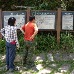
he Forestry Bureau has set up an explanatory board by the entrance (Shilu end) of the Syakaro National Trail in Wufeng Township, Hsinchu County. Syakaro Historic Trail, also known as Shilu Historic Trail, has two entry points, one in Qingquang, Wufeng Township, Hsinchu County, and the other end is in Xiuluan Village, Jianshi Township. The Syakaro incident happened twice in the sixth year and ninth year of Taisho (1917 & 1920). At that time, there was only one Aiyong border within the old Hsinchu Prefecture. Therefore, in mid-November of the 9th year of Taisho (1920), it was planned to dig a new Lifan road from Shangping to the dispatch station to suppress and monitor the Syakaro group.
At the end of March in the 11th year of Taisho (1922), the "Syakaro Trail" was completed. In April of the same year, a total of 19 new police posts were successively established along the trail. In the 13th year of Taisho (1924), the security stations at both ends of the trail were changed to police posts to improve the security of the entire road.
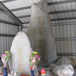
The Hengduan Road Excavation Monument is located next to Provincial Highway 9 in Gancheng Village, Ji’an Township, Hualien County. It was set up by the Governor-General in Taiwan for the road excavation team to commemorate the completion of the east section of the Nenggao Traversing Historic Trail. The whole trail is 90 km from Chuyin to Wushe, and the east section is about 44 km long. Due to the steep terrain in the east section, the construction was arduous, and many were injured or died. Therefore, the monument was set up when the road was completed in 1918. The inscription on the monument details the labor and cost of excavating the road, and records the names of those who died in the construction.