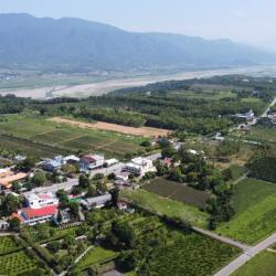
Wuhe Terrace in Ruisui Township, Hualien County, is located southwest of the confluence of Xiuguluan River and Hongye River. The cultivation began during the Japanese occupation, when Japanese companies established the Hualien Port Coffee Farm here and recruited Taiwanese immigrants to grow coffee. Hakka immigrants from the Taoyuan, Hsinzu and Miaoli area are the mainstays. Workers’ accommodations were built in the area of Saobading and gradually a small settlement was formed. Unfortunately, the originally planned tea colonization plan could not be successfully carried out due to the outbreak of the Pacific War. Until the post-war period, the National Government began to promote tea cultivation on the Wuhe Terrace. In its heyday, the tea plantation once covered 300 hectares and became the main tea-producing area in the east. The look of the tea village has been maintained to this day.
Xiuguluan River
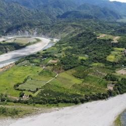
Dewu River Terrace is located on the east side of the confluence of Xiuguluan River and Fuyuan River in Ruisui Township, Hualien County. It is the starting point where Xiuguluan River cuts through the coastal mountains.
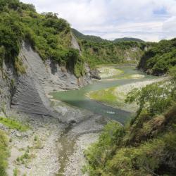
The traditional name is Lulnu, which means paper mulberry because in the past, there were many wild paper mulberry trees here. It is also an area where the Amis people do dry farming and grazing. Overlooking from the Ruigang Industry Road, it is clear that the Dewu River Terrace descends from south to north. This shows that the river is continuously migrating to the north during the downward cutting process, which results in asymmetric growth meanders on both sides of the river bank. In addition, there is a prehistoric cultural site on the hillside of the Dewu River Terrace as fragments of plain pottery from the Jingpu hamlet have been found. This presumes that this was where the Amis people lived in the early days.
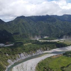
Houzishan (Monkey Mountain) is a river terrace along the Xiuguluan River that is located on the east side of the Dewu river terrace in Ruisui Township, Hualien County. Its traditional name is Kawasan, which means a place where gods and ghosts appear. Therefore, it is also called Ghost Mountain. It is said that macaques came here to forage in the past. Xiuguluan River is the largest river in eastern Taiwan, with a total length of about 104 km. In the process of cutting through the coastal mountains, many steep canyons have also been formed, resulting in developed meanders and river terraces, such as Dewu River Terrace, Monkey Mountain, and Chimei River Terrace. This makes an excellent classroom for observing geology or topography.
The Xiuguluan River begins from the Central Mountain Range. It runs north along the Huadong Rift Valley, and turns eastward at Ruisui Township in Hualien County. Then it cuts across the coastal mountains and finally flows into the Pacific Ocean at Dagangkou (Cepo’) Hamlet. It is the largest river in eastern Taiwan with a total length of about 104 km. Also, it is the only river in Taiwan that cuts through the coastal mountains. During the process of cutting through the coastal mountains, the Xiuguluan River also cuts many steep gorges, resulting in some quite developed meander and river terraces, such as Dewu River Terrace, Monkey Mountain, and Chimei River Terrace. This makes an excellent classroom for observing geology or topography.
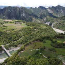
Chimei River Terrace of Ruisui Township, Hualien County, is located at the confluence of the Xiuguluan River and Chimei River. The single-sided mountains, circulation mounds and river terraces in this area are quite developed, and the Chimei Hamlet is located on the platform of this river terrace. Chimei River was originally a turbid current that entered the sea. But during the uplift of the coastal mountains, it continued to erode toward the source, which changed its course and converged into the current Xiuguluan River. In addition, the Chimei Fault is the most important active fault in the coastal mountains, with a total length of more than 30 km. The stratigraphic structure of the Chimei River on the west can be seen from Ruigang Industry Road.
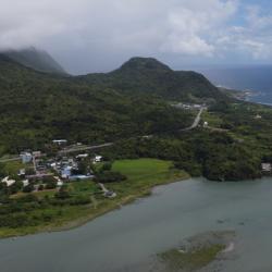
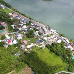
Dagangkou Hamlet is located on the north bank of the Xiuguluan River estuary in Fengbin Township, Hualien County. The traditional name of the place is Lanun, which means the village below, and the traditional name of the hamlet was Ciporan. During the Qing period, the hamlet was called Sipuolan, Xuepuolan, Xiuguluan, Xiuguluan, Zhiwulan, and so on. It was not until 1887 when Puyuma and Ouyang Jun opened the port that the name was changed to Dagangkou. In the same year, the Dagangkou (Cepo’) incident occurred. After the incident, the tribesmen who had moved to other places were called to return to the community. They chose a settlement north of the original site, which is the present Gangkou hamlet. During the Japanese occupation, due to the gradual population increase, some people began to move south to live in the Dagangkou hamlet.
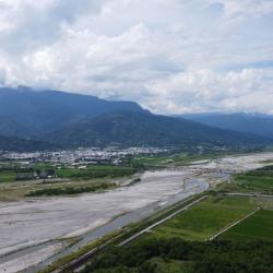
Yuli Township is located in the south-central section of Hualien County. It became a village in 1875 and was called Pu-Shi-Ge during the Qing period. There are many saying how the name originated. First, Pusiko is how Bunun people describe dust and sand that they saw flying above Xiuguluan riverbank. Secondly, Paheko is how Amis people describe ferns because the riverbank plain was covered with ferns. Third saying was when General Wu Guangliang opened the road in 1875, he saw pure white jade all over Xiuguluan river and named the place Pu Shi Ge, namely the unpolished gem pavilion.
At the end of the Qing period, Pushige village was already a military powerhouse and a Han settlement, with an area equivalent to the current urban Yuli.
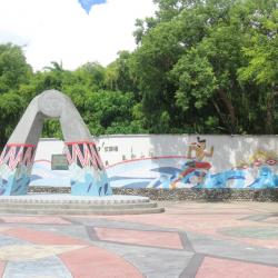
The Cepo’ Incident Monument is located inside Jingpu Elementary School in Fengbin Township, Hualien County. It was established in 2014, which is the 127th anniversary of the Cepo’ Incident.
The Cepo’ incident happened at the end of the Qing Dynasty, when Wu Guangliang, the commander-in-chief of all roads in Houshan, was resisted by the Amis people of Jingpu and Gangkou area for excavating roads for Shuiwei to Dagangkou port (Cepo’). Therefore, in 1877, General Lin was sent to lead a troop to suppress the Amis people. Almost a hundred Amis people were killed at the incident, and the surviving tribesmen fled, dispersed to the east coast and the Huadong Rift Valley. The area around Jingpu became the base camp for the Qing troops.
The Jing’an Hamlet is located on the south bank of the Xiuguluan River’s estuary in Fengbin Township, Hualien County. Due to its flat terrain, it is on the same straight line as Jingpu Hamlet. The traditional name, Tisilan, is derived from the Amis word “Saadisi”, which means on a straight line. At the end of the Qing period, due to the Cepo’ incident, the Qing soldiers originally stationed in Dabei moved here and renamed it Dagangkou Camp. Later, the Han people moved in, and the place is known as Da Pian Yuan. It was not until the post-war period, when house number plates were issued, that the place was renamed to Jing’an. In the 1980s, due to the increased population, Jing’an hamlet gradually got separated from the bigger Jingpu hamlet. At present, the Jing'an hamlet is mainly concentrated by Han people on both sides of the provincial highway 11.