Tayal

Kara Hamlet
從高處遠眺卡拉部落

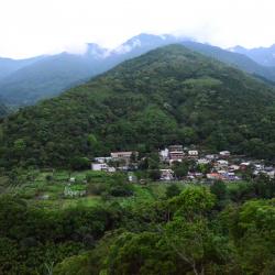
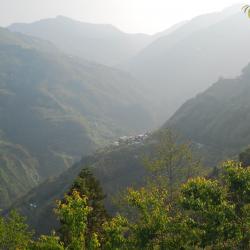
The Kara Hamlet is located 3 km northeast of Shangbaling in Fuxing District, Taoyuan City, on the hillside on the south bank of Daguan River. It sits 900 meters above sea level, and the traditional Atayal name is Qara, which means separate or branch.

In the past, two brothers had to separate due to insufficient hunting grounds. The eldest brother and his family stayed in today’s Baling Hamlet, while the younger brother took their family and arrived at the old tribe, which is on the hill opposite to the current Kara Hamlet.

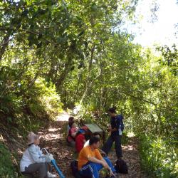
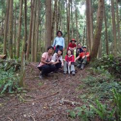
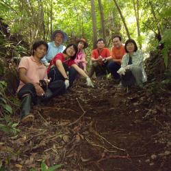
Many years ago, due to typhoons the people moved to Kara hamlet for the safety of their homes and traffic reasons. It is a hamlet of around 20 households, mainly living in the vicinity of the boat-shaped church.

Fushan Hamlet
從高處遠眺福山部落

The Fushan Hamlet is located in the upper reaches of Nanshi River in Wulai District, New Taipei City. It was the earliest hamlet established by the Atayal people in Wulai District during the Qing period. They were the Talanan and Limao-an tribes.

Later, due to the increased population, the tribes began migrating to the lower reaches of Nanshi River. Through social changes, the people living in Fushan hamlet further established the Tunlu, Limao’an, Karamuki and Daluolan hamlets.

During the Japanese occupation, the Governor-General in Taiwan set up the Limao’an Police Post in Limao’an hamlet. After that, the Mitsui Gomei Company took the land and forced the people to move. In the post-war period, the National Government delineated the administrative area and merged the hamlets into Fushan village.


Tarakkas Police Post (Suyuan Police Station)
タラッカス駐在所(粟園派出所)遺留的夯土牆

The Tarakkas Police Post (Suyuan Police Station) is located on the northern branch of the western edge of Yanglaoshan (Mount Yoro), about 1,415 meters above sea level and has a foundation of more than 400 square meters. It was established in 1920, at which time, the Syakaro Trail had not been opened. Originally, there was a hamlet named Trakis, which means millet. During the Japanese occupation, the Governor-General in Taiwan used the name and pronounced it タラッカス (Tarakkas).

In the early post-war period, the National Government took over and renamed it Suyuan Police Station, which was abandoned in 1959. Today, Tarakkas Police Post is in the plantation area of makino bamboos. The plantation has caused great damage to the foundation, but there are still traces of rammed earthen house foundations, houses and walls.

Laihu Police Post
瀨戶駐在所的遺址所在

The Laihu Police Post is located on a convex ridge  south-west of Mount Mingdouyo with a panoramic view. It is at an altitude of about 1,030 meters and on a 1,000 square meters wide foundation. In the early days of the Japanese occupation, when the Governor-General in Taiwan sent its troops to set up the Aiyong Border, it first set up a checkpoint here. Later in 1922, the Laihu Police Post was set up, facing Atayal’s Yehmakan Hamlet of the Syakaro group across the river.

In the early post-war period, the National Government took over and used it as a police station. It was renamed successively to Minsheng Police Station and Yunshan Police Station. Finally, when it was converted into a brick structure in 1963, the name was changed back to Minsheng Police Station.

Today, the police station has been relocated to the opposite bank of the Syakaro River. Only the foundation and stacked stone walls remain at the former site.


Ma’an Police Post
養老山西稜鞍部,馬鞍駐在所位於旁邊制高地

The Ma’an Police Post, established in 1922, is located on the small saddle on the western edge of Yanglaoshan (Mount Yoro), about 1,460 meters above sea level, on a foundation of more than 400 square meters. Based on legend, the name of the first Atayal who came here to reclaim the land was Bawan, and so, the traditional Atayal name of this place was named after him. Later in the Japanese Occupation period, the Governor-General in Taiwan transliterated it as Ma’an.

In the early post-war period, the National Government took over and turned it into the Ma’an Police Station, which was later abandoned in 1959. Today, the remains of rammed earthen houses and walls of the police post can still be seen on site.

Wusheng Police Post
調查人員在通往武神駐在所的叉路口休息

The Wusheng Police Post is located on the northwestern edge of Mount Bunugari, about 1,430 meters above sea level. It was established in 1922, when the Syakaro Trail was completed during the Japanese occupation. It was the peak of the police force, however, after a lapse of 5 years, the police post was withdrawn when the police force was deployed. In the past, the Wusheng Police Post faced the Jianfan Police Post on the opposite bank of Skayacin Creek.

To this day, the police post still maintains a complete slope and stone ridge, and the Forestry Bureau set up an information board introducing Wusheng Police Post, its story and the spatial configuration at that time.

Sakayachin Police Post (Baishi Police Station)
木造瓦頂的白石派出所辦公廳

Sakayachin Police Post is located on the north side of Zuotengshan (Mount Sato) along the 2328 peak to the tail ridge in the northeast. It was established in 1922 and is about 1,630 meters above sea level. It was the most important stronghold on the Syakaro Historic Trail during the Japanese occupation, equipped with 30 guards. In the post-war period, the National Government changed its name to Baishi Police Station, and rebuilt the office dormitory in 1969. As a fact, the back door of the Baishi Police Station is the entrance to the road leading to Zuotengshan (Mount Sato). The road is not used nowadays and therefore, the Forestry Bureau put up warning signs to prevent hikers from entering by mistake.

Tianchuntai Police Post
調查人員於田村臺駐在所的正門口合影

Tianchuntai Police Post is located at the mountainside of 1998 peak and Mount Gaoqiao in Wufeng Township, Hsinchu County. It was established in 1922, and was named after the surname of the first police officer in charge, Tamura Yuichi (Tianchun Yongyi). The traditional Atayal name for the place is Tarofun. In the early days of the Japanese occupation, after two occurrences of the Syakaro incident, the Governor-General in Taiwan named this place Mukaraka Highland, and excavated the Luchang Lianling Road in 1925. Tiancuntai was the road’s starting point.

Today, Tianchuntai Police Post is located in the plantation area of Japanese Cedar. Due to the afforestation work, some sites of the police post have been destroyed. Only the gate ramps, stacked stone foundations and fort sites remain visible.

Zhuangzi Police Post
庄子駐在所後方高約1公尺的駁坎

Zhuangzi Police Post is located above the parking lot at the entrance of the present Syakaro National Trail, about 1,780 meters above sea level. After the construction of the Syakaro trail was completed during the Japanese colonial period, the Governor-General in Taiwan believed that this was an important strategic location. Therefore in 1922, the Zhuangzi Police Post was established with a foundation of more than 100 square meters. After a lapse of 2 years, it was removed because the area was considered quiet. 

Today, due to the widening of industrial roads and the excavation of the parking lot, the forecourt of Zhuangzi Police Post has collapsed. The remaining building structures that are still visible are rammed earthen walls, fort foundations, and stone ridges. 


Xiaolin Police Post
調查人員於小林駐在所的大門石階上合影

The Xiaolin Police Post, located on the first long ridge to the east of the Syakaro Police Post, was established in 1922, and named after the first Japanese supervisor’s surname. However, the police post was withdrawn after a lapse of 8 years. In order to cope with topographical changes, the foundation of Xiaolin police post is mainly L-shaped, with stone ridges built in the front and rear, which are still complete today.