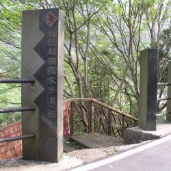
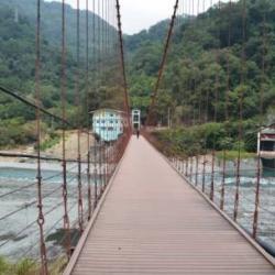
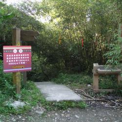
Fushan Village is located in Wulai District, New Taipei City. It is the most inland village in Wulai District, and it is also the starting point of the northern end of the Fuba Cross-ridge Historic Trail. The historic trail is a popular route in the mountaineering world. From Wulai Fushan to Balinglala Mountain, the length of the trail is about 17 kilometers, and can be completed in about a day. The protected area is rich in ecological resources. The trailhead is located opposite the residential house on No. 2 Daluolan. The entrance is marked with "Fuba Cross-ridge National Trail". Go down the stairs, pass the Fushan Suspension Bridge, and you are on the historic trail.
Atayal
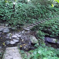
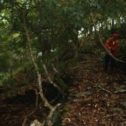
First creek after entering the trail
Hapan Historic Trail starts from Fushanli, Wulai District, New Taipei City in the west, and ends in Lunpi Village, Datong Township, Yilan County in the east. The original starting point was near Xinxian Village, Wulai District, along the right bank of Nanshi River to Fushan Village, and then turned to Hapen direction. Later, due to the excavation of modern roads, the trailhead was also moved to the Karamoji Industrial Road on the opposite bank of Fushan Village.
It was formerly known as the "Shenkeng to Yilan Crossing Aiyong Boarder", built in built in Meiji 38 (1905). In Showa 6 (1931), the Police Department of the Taiwan Governor's Office rebuilt the road to relocate the indigenous people of the Ka’aowan group from Takasan and Gaoyilan communities. The road continued to be used after the war until now.
Chinuosi-she
The migration process of the Chinuosi-she that got passed down orally is almost identical to that of the Gogotsu-she, and the relationship between the two communities is very close. Chinuosi-she was established during the time of the chief Meraaran. At that time, they were living with Gogotsu-she on the Tbunan platform on the right bank of the Bouxiao Wanxi estuary. After a while, Meraaran found that the Chinuosi-she was suitable for settlement and moved here. However, the tribe has difficulty in obtaining water because Chinuosi situated in the middle of the mountain, facing the north Heping River with a steep cliff in the southwest. Therefore, they began migrating to the south Nan’ao River, around 4 kilometers east of sendan police post in 1915. In 1920, many people died due to influenza and malaria and in 1923, Chinuosi-she relocated to the right bank of south Nan’ao River, around 1.3 kilometers south of sendan police post, and renamed Xuantanshe, with a total of 52 people of 16. households. As the land was too sloping and difficult to cultivate, the cmmunity relocated again to a platform 1 km northeast of the sendan police post in 1931, and finally moved to the current Jinyang Village.
Gogotsu-she
The ancestors of the Gogotsu-she came from the upper reaches of Dajia River. They passed through habun sublus and Nanhu Mountain, and finally settled in a place called bbu (meaning flat top) in the upper reaches of north Heping River. They have also lived in Piahaushe and after that, went down along the north Heping River and lived on the Tbunan platform on the right bank of the Boxiaowan River estuary. Due to the increasing population and lack of arable land, the people later migrated to Gogotsu-she. Since 1913, members of the Gogotsu-she have successively moved to Sifanglin and upper Dong’aoshe in Hanxi Village (north of Dong’ao Police Station). Originally it was called lower Gogotsu-she, with a total of 59 people of 11 households. In 1922, it was renamed the Upper Dong’aoshe.
Kubabo (K’babaw)
"Bbu" means "a place with a good view from the platform on the mountain" in the Atayal language. From the name, it is clear how the terrain of this hamlet is like. The hamlet is located at the intersection of the left bank of the north Heping River and the Mohen River, at an altitude of about 1,200 meters. The Japanese Occupation Security Road passes below the hamlet, leading to Liuxingshe in the east and Jinyangshe in the west. There is an Education Center for indigenous children and a fort in Kubaboshe. At present, the school playground, the command platform, and the drainage ditch can still be seen in the hamlet.
In the early days, traditional Atayla house was used as the official’s office. Later in the first year of the Showa era (1926), the Japanese built the Kubabo police post using cypress wood. However, there are no traces of the wooden structure of the building any more, only huge stacked stone foundations remain.
Xianbi Police Post
Located on the southern edge of Qianliang Mountain, at an altitude of about 750 meters, the platform behind the shelter is the foundation of the Xianbi Police Post from the Japanese occupation period. The police post was established in the 13th year of Taisho (1924), and until today, there are fragments of utensils, guns and ammunition depots from the Japanese occupation period on the ground.
Shengguang Police Station
Shengguang Police Station is located 49.5 kilometers away from Central Cross-island Highway Yilan branch line. During the Japanese occupation, in order to facilitate transportation and manage the indigines, the Pyanan Historis Trail was built in the 7th year of Taisho (1918). The route starts from today’s Datong Township, Yilan County and extended to Wushe in Nantou County, with a total length of 120 kilometers. The trail was completed in the 10th year of Taisho (1921).
The biggest feature of this road is that it almost presents a "north-south" road system. Most of the Lifan roads are east-west, which makes this trail one of the six north-south roads. The Pyanan Historic Trail passes through the Atayal territory, forming a longitude and latitude with the east-west Lifan road, interweaving into a traffic network, and playing a very important role in the history of mountain transportation during the Japanese occupation. After the war, this historic trail was replaced by the Yilan branch of the Central Cross-island Highway and the Lixing Industrial Road.
Tianlun Baileng Suspension Bridge
This suspension bridge that leads to the Baileng Police Post can be seen from the 1/50,000th topographic map of the Japanese rule during the Showa period. The bridge was the predecessor of the monitoring route of Baileng Aiyong Border, which was excavated on February 23, Meiji 44 (1911). The route began from the Beileng Supervision Office, going up the Dajia River and arriving at the シウワンタイム, with a total length of about 4 miles (about 16 kilometers). In the 3rd year of Taisho (1914), because the original old defile was very narrow, Taichung Office planned to widen the road from Dongshijiao to Baxianshan to facilitate the logging business. It was finally excavated by the Forestry Bureau of the Governor's Office of Taiwan, but the road still ended in Jiurai (now Songhe, Heping District, Taichung City).
Fushan Mountaineering Entrance
Hapen Historic Trail starts from Fushanli, Wulai District, New Taipei City in the west, and ends in Lunpi Village, Datong Township, Yilan County in the east. Formerly known as "Shenkeng to Yilan Crossing Aiyong Boarder", when the Japanese government rebuilt thisroad for relocating the indigenous people of the Ka’aowan group from Takasan and Gaoyilan communities in Showa 6 (1931). The original starting point was near Xinxian Village, Wulai District, follow the right bank of Nanshi River to Fushan Village and then turn to the direction of Hapen. Later, due to the excavation of modern roads, the mountaineering entrance was also moved to the Karamoji Industrial Road on the opposite bank of Fushan Village.
Tianfu Bridge
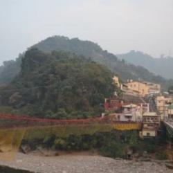
The image of a new community, Fuxing village, was taken from Tianleng. The path on the left side of the settlement is the forest railway that was used in the former Basianshan Forest Farm, leading to Basianshan.
Baxianshan Forest Farm was one of the three major forest farms in Taiwan during the Japanese occupation. The logging of the forests began in November of the 4th year of Taisho (1915). In the 5th year of Taisho (1916), the Forestry Bureau of the Taiwan Governor set up a Basianshan branch office in Jiabaotai that ministered to various businesses. Afterward, after various transfers, in Showa 17 (1942), Taiwan Takushu Co., Ltd. was transferred to become a government-business joint venture. After the war, the logging business continued in this field, and the production volume exceeded the sum of the Japanese occupation period by the mid-1950s. In 1963, the forest farm stopped production. At present, Basianshan is under the Dongshi Forest Area Management Office of the Forestry Bureau.