Tayal

Lileng Hamlet
裡冷社區活動中心即為裡冷駐在所舊址

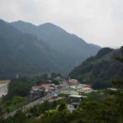
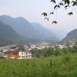
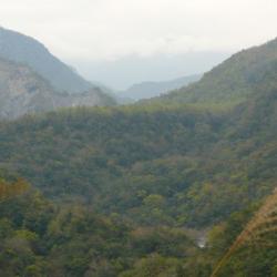
Lileng Hamlet is located on the western fan terrace where the Dajia River and Lileng River meet in the Heping District of Taichung City.  The Atayal traditional name for the place is Qalang Lilang. People of Lileng Hamlet originally lived in Hongxiang Hamlet in Renai Township, Nantou County. However, in the early days of the Japanese occupation, with the push of the Aiyong border in Dajia River, the Governor-General in Taiwan set up the Lileng Police Post there, and collectively moved the people to the vicinity of the police post. This formed the Lileishe or the Lilanshe, which is the present Lilen Hamlet.


Bailu
從高處俯瞰白鹿

Bailu is located on the right bank of Dajia River in Heping District, Taichung City, about 2 kilometers southwest of Baileng. It is a train station for the Baxianshan Forestry Railway built during the Japanese occupation period. The Japanese name for Bailu is Hakushika, and is the first station to arrive in the indigene territory after passing through Mazhukeng Station. In the early days of Japanese rule, the Governor-General in Taiwan started the logging business in this area after having transported the first batch of timber from Baxian Mountain in 1915. Baxianshan Forest Farm was one of the three largest forest farms in Taiwan during the Japanese occupation. At the beginning of the operation, all loggers were hired from Japan. Since 1930, due to changes in related laws and regulations, the forest farm gradually accepted Taiwanese, which attracted many laborers.

Songhe Hamlet
從高處遠眺松鶴部落

Songhe Hamlet is located on the fan terrace on the left bank of Dajia River in Heping District, Taichung City. In the early days of Japanese rule, the tribes of the Tbulanshe and Sirakushe migrated and settled here, formerly known as Jiuliangqi. The forest alley in Songhe hamlet was the railway of the Baxianshan Forest Farm, one of the three largest forest farms in Taiwan during the Japanese occupation. At the beginning of the operation, all loggers were hired from Japan. Since 1930, due to changes in related laws and regulations, the forest farm gradually accepted Taiwanese, which attracted many laborers.

Today, there are still many Japanese-style houses remaining in the alleys of the Songhe Hamlet Forest Farm, which are forest farm staff dormitories.


Shanjiao Police Post
山腳駐在所的遺址

The Shanjiao Police Post is located on the branch of the east riverbank of North Nan’ao Creek in Datong Township, Yilan County.  It was built in 1919 and is about 750 meters above sea level. In fact, the Piahau Historic Trail, which runs through Nan’ao Township and Datong Township in Yilan County, was built in 1919. There is also a Tongshan branch route that reaches Hanxi Village in the north and connects to the main route near Leyoxenshe. The main route is about 87.2 km in length and the branch route is about 44.2 km, both pass through the traditional territories of the Atayal tribe of the Nan’ao group.

During the Japanese occupation, Taiwan’s Governor-General used the Piahau Historic Trail as the path for migrating the Atayal people, forcing them to move out of their village. In the early post-war period, the National Government also forced the tribes to move to the plains.

Piahau Historic Trail
比亞毫古道封面照

The Piahau Historic Trail, which runs through Nan'ao Township and Datong Township in Yilan County, was built in 1919. There is also a Tongshan branch route that reaches Hanxi Village in the north and connects to the main line near Leyoxen'she. The main route is about 87.2 km in length and the branch route is about 44.2 km, both pass through the traditional territories of the Atayal tribe of the Nan’ao group. During the Japanese occupation, Taiwan’s Government-General used the Piahau Historic Trail as the path for migrating the Atayal people, forcing them to move out of their village. In the early post-war period, the National Government also forced the tribes to move to the plains, and the last tribe to be moved was the Hagaparis.

Today, the Piahau Historic Trail is classified as a national trail. Most sections of the road still exist and are accessible although the trail has not been fully restored.

Kumoyaoshe
絕壁的頂端平臺即為庫莫瑤社

Kumoyaushe is located on the top platform of the cliff in Nan’ao Township, Yilan County. To get there, it is necessary to start from Liuxingshe on the east side of the Piahau Historic Trail, travel south through the hot springs and then turn to the west, passing by Maobian Police Post, Kubabuoshe, Kelumuo’anshe, Kigayanshe and Jingyangshe. In the early days of Japanese rule, Taiwan’s Government-General had established a police post here in 1911.

Tabihanshe
塔壁罕社的遺址

Tabihanshe is located in Nan'ao Township, Yilan County. The traditional Atayal name for the place is Təbiyaxen, which means wild peony. There are two theories recorded about the establishment of the community. One is the survey records of the Derakanshe during the Japanese occupation. The other theory is when Buta Naui, the then chief of Derakanshe, migrated some tribesmen down the right bank of South Nan’ao Creek and established the Tabihanshe about 1.5 km away from the Derakanshe due to the increasing population and insufficient arable land. It was not until his son succeeded; the two communities have a clearer independence. Although the second theory is better known, it retains its doubt.


Kigayan Hamlet
基嘎央社的遺址

Located in Nan'ao Township of Yilan County, Kigayan Hamlet is located about 1 km west of Jingyang Hamlet, on a flat land below the then garrison road of the Japanese. The Atayal traditional name for the place is Kikeyan, which means footprints. Rumor has it that the name came about people leaving their footprints when passing through this area. As a fact, where Kigayan Hamlet used to be was originally the cultivated land of the Jingyang Hamlet. Later, three tribal families moved here and established a small community. According to Field Reporter Doras, at the beginning there were only three households with eight people in the Kigayan community. Then it increased to 18 households with 69 people. At the end of the Japanese occupation period, the tribes moved to the present Jingyang Village and Aohua Village, leaving only five households in Kigayan.


Tawan
1903年本田正己調查隊行經塔貝賴社的社路

Tawan (or Tabera) in Datong Township of Yilan County, is located in the Beixi River Basin of Danan'ao. In the early days of the Japanese occupation in 1903, Yilan Police Officer, Honda Masaki, led a team into the mountainous area to investigate the area. Below the confluence of Nan'ao Creek, there were two roads. One was to climb the Yaplasai Mountain to reach Liuxingshe, and the other was to cross the west side of the Yaplasai Mountain to reach Taberashe. After the investigation was completed, a report was submitted. This document pointed out that at the time there were 15 communes in Nan’ao, and the path to those communes in Nan’ao was more difficult than the road into the mountains in Danan’ao.


Shu’anbu
曙鞍部即為北坑山和鹿場大山稜線的最低鞍

Shu’anbu is located at the lowest saddle on the ridge line of Mount Beikeng and Luchang Dashan, about 2,000 meters above sea level. It is a small flat land but was the transportation hub between Shangdao Hot Spring, Luchang Dashan, Luchang, Shu, Beikeng and other transportation hubs during the Japanese occupation. In the past, there used to be huts for people to rest.

Today, Shu’anbu is covered in overgrown miscanthus, making it difficult to look out at the scenery. Also, no items left from the Japanese occupation period have been found. The section of the historic trail leading to Sishui Police Post has been seldom used and the road conditions are not suitable for hiking.