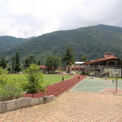
Nanshan Elementary School is located in Nanshan village, at an altitude of almost 1,200 meters. It is an indigenous school with Atayal culture. The predecessor of Nanshan Elementary School was the "Pyanan Indigenous Children's Education Center" during the Japanese occupation period. It was established in May of the 9th year of the Taisho era (1920). In November of the same year it was open for school. In September of the 10th year of the Taisho era (1921), it was changed to "A-type Indigenous Children's Education Center", and the additional school building was completed in December of the same year. In May 1946, it was taken over by the National Government and changed to "Beinan Branch of Siji National School in Taiping Township, Taipei County". In August 1962, it became independent as "Nanshan National School in Datong Township, Yilan County". In August 1968, the nine-year national education was implemented, and the school was renamed "Nanshan National Elementary School". In 1991, the reconstruction of classrooms, dormitories and playgrounds was completed.
Tayal
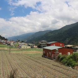
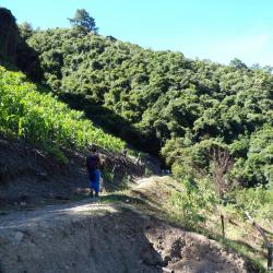
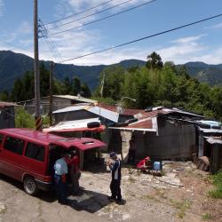
The Nanshan Tribe is located at 28K of the Taiwan Provincial Highway 7 of the Central Cross-island Highway Yilan Branch Line, at an altitude of 1,200 meters. It is a river terrace on the left bank of the upper reaches of the Lanyang River. It was originally called pyanan, meaning cooking, because in the past, the Atayal people often rest and cook here. In 1959, the Yilan branch of the Central Cross-island Highway was built. At that time, Premier Jiang Jingguo of Executive Yuan passed by here and felt that the name of Pyanan was indecent, so he took the word Nan and changed the name of the village to Nanshan Village. Nanshan Village is divided into upper and lower hamlets. Kanaban is the lower hamlet, and is located about 300 meters north of the Nanshan Police Station. It is the original location of Pyanan Hamlet and as it locates belo the terrace, it is called the lower hamlet. Koxao is the upper hamlet. In 1913, the Japanese forces penetrated into the Nanshan area and set up a station at the current site of the Nanshan police station. In order to disperse the power of the indigines, the leader Losin-nobo moved half of the community members to live near the station and called it Koxao because of its nose-like landform.
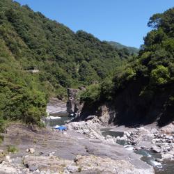
Where Taigang and Baishi River join is called Yufeng River. After crossing Xiuluan, you can see a huge rock on the other side of the river that looks like a sailing warship protruding from Yufeng River. During the Japanese rule, there was a suspension bridge that led to Zhishengmaotai Mountain on the opposite bank. The bridge was demolished in the 1970s because it was unsafe for crossing. In addition to the Xiuluan Hot Spring below the Xiuluan hamlet, you can also see bubbling river surface below the Junjianyan (Warship Rock), were hot spring gushes out from the rock crevices. It is the outcrop of Junjianyan Natural Hot Spring, a carbonated spring with a water temperature of about 50 degrees celcius. It is suitable for bathing when the temperature is adjusted through mixing stream water and hot springs. Tourists often camp near Warship Rock during holidays.
The location of the Yanglao Police Post from the Japanese rule has been converted into a working house today due to the widening of the road. Yanglao Hamlet belongs to Xiuluan Village, Jianshi Township, Hsinchu County. It is located on the left bank of Xiuluan River and the northern foot of Mount Sinaji, at an altitude of 900 to 1500 meters. The mountainside belongs to the Kinaji group of the Atayal ethnic group. Yanglao is a transliteration of Yuluw in the Atayal language, which refers to the rat board under the barn.
Departing from the entrance at the Yanglao end, heading towards the millet garden, you will see orchards on both sides of the road. The entrance at the Yanglao end is about 1250 meters. After passing the orchard, it is a gentle uphill slope. Since this is a middle altitude area, there are many different broad-leaved tree species, such as green maple, Taiwan alder, liquidambar, and some coniferous trees. The trail is about 3.5 kilometers and takes an hour. When entering the osmanthus bamboo forest, you will see a round charcoal kiln by the trail.
The Baishi Suspension Bridge was first built in the 10th year of Taisho (1921) and rebuilt in 1947. The bridge is about 145 meters long and 90 centimeters wide, crossing the main stream of Sakyacin Creek. Skayacin means white stone (Baishi) in the Atayal language. Sakyacin Creek originates from the west side of the north edge of Dabajian Mountain, and is one of the two major tributaries of the upper reaches of Dahan River. In recent years, due to the increase in the number of tourists, it has been renovated again in consideration of safety, and an explanatory board is set up beside the bridge.
The northwest saddle of Syakaro Mountain is the crossing point of the entire trail. The Japanese excavated the saddle to facilitate passage, forming a door-like passage. The local Atayal people named it Belefun, which means "door".
Going eastward from the saddle for a few minutes and the ridgeline on the right leads to the entry of Syakaro Mountain. From there, walk for about 20 minutes and the northern saddle of the mountain will be on the left. It takes about 1.5 hours round trip to climb Syakaro Mountain. Due to the strategic location, Matsushita police post was set up there in Taisho 11 (1922), which is the highest police post along the Syakaro Trail.
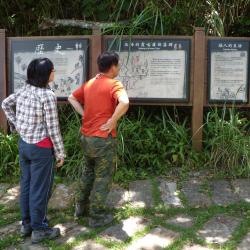
he Forestry Bureau has set up an explanatory board by the entrance (Shilu end) of the Syakaro National Trail in Wufeng Township, Hsinchu County. Syakaro Historic Trail, also known as Shilu Historic Trail, has two entry points, one in Qingquang, Wufeng Township, Hsinchu County, and the other end is in Xiuluan Village, Jianshi Township. The Syakaro incident happened twice in the sixth year and ninth year of Taisho (1917 & 1920). At that time, there was only one Aiyong border within the old Hsinchu Prefecture. Therefore, in mid-November of the 9th year of Taisho (1920), it was planned to dig a new Lifan road from Shangping to the dispatch station to suppress and monitor the Syakaro group.
At the end of March in the 11th year of Taisho (1922), the "Syakaro Trail" was completed. In April of the same year, a total of 19 new police posts were successively established along the trail. In the 13th year of Taisho (1924), the security stations at both ends of the trail were changed to police posts to improve the security of the entire road.
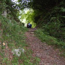
Shilu Hamlet is located on the south-facing long ridge of a small hill in the east of Mindu Mountain. In the early days, this area was rich in magnolia compressa, thus, the Atayal people called this place Skaru. Skaru refers to the magnolia compressa tree, which is widely distributed in the broad-leaved forests of middle and low altitudes in Taiwan. In the 2nd year of Taisho (1913), the Aiyong Supervision Office was set up in this area. It was named Syakaro, after the transliteration of Skaru, which got transliterated later as "Shilu". This image shows the current situation of the Shilu hamlet, and above the hamlet is the Syakaro police post from the Japanese occupation period, which was renamed the Shilu Police Station after the war.
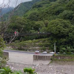
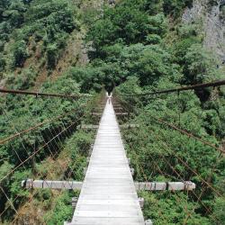
Qingquan No. 1 Suspension Bridge is located in Qingquan Hamlet, Taoshan Village, Wufeng Township, Hsinchu County. It is about 535 meters above sea level and crosses Shangping River. Qingquan No. 1 Suspension Bridge also connects to Qingquan Police Station. It is about 157 meters long, 25 meters high, and 1.4 meters wide, and is the highest suspension bridge in the Qingquan area. You can overlook the entire Qingquan area from the bridge. Where the bridge is standing was the original site for the Inoue Railway Bridge during Japanese rule. Both ends of the bridge still have sections of the Syakaro guard road remaining from those time. The Railway Bridge was damaged due to disrepair for a long period of time and in 1996 the current bridge was rebuilt on the same site.