Tayal

Song’an Police Station
2003年松安派出所尚未拆除的水泥建築

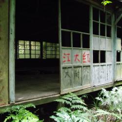
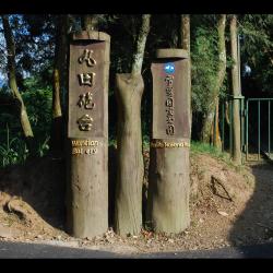
The Song’an Police Station, in Tai’an Township of Miaoli County, was originally the Erbensong Police Post during the Japanese occupation, built in 1911. In Japanese, Erbensong refers to a place with two pine trees. The traditional Atayal name for the place is Pihun, which means door. Both have the meaning of entering Beikeng Creek.

The Erbensong Police Post was set up with the purpose of monitoring the northern group of the Atayal tribe in the Da’an River Basin during the Japanese rule. However, there have been fierce attacks by the Atayal tribe. In the post-war period, the National Government changed its names to Erbensong Police Station and Song'an Police Station.

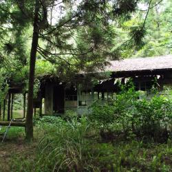
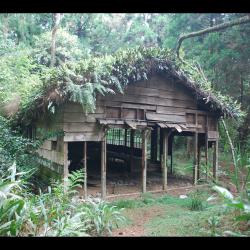
When the Jiji earthquake occurred in 1999, police officers were moved to Meiyuan Police Station, which has now been converted into Erbensong Visitor Center.

Sign posting for Beikeng Police Post
北坑溪古道由觀霧入山14.6公里處所設立的北坑駐在所指標

The Beikeng Police Post, in Tai’an Township of Miaoli County, was established in 1923. It is located on the 14.6 km point of the Beikeng Creek Historic Trail and is about 1,640 meters above sea level. The traditional Atayal name for the place is Simayen, which means floor-like lawn.

The Beikeng Police Post was originally the administrative center of the Beikeng Creek Historic Trail. There was an education center, Wude Hall, medical facility, places for trades, guns and ammunition depot and so on, of which the buildings still remain on the trail today.

Around 2003, Xuepa National Park renovated the historic trail section from Guanwu to Erbensong, but due to natural disasters, the entire section was still difficult to pass through and was abandoned. Only a few parts of the trail remain.


Beikeng Police Post
北坑駐在所遺址上的木造工寮,刻畫著到此一遊印記

The Beikeng Police Post, in Tai’an Township of Miaoli County, was established in 1923. It is located on the 14.6 km point of the Beikeng Creek Historic Trail and is about 1,640 meters above sea level. The traditional Atayal name for the place is Simayen, which means floor-like lawn.

The Beikeng Police Post was originally the administrative center of the Beikeng Creek Historic Trail. There was an education center, Wude Hall, medical facility, places for trades, guns and ammunition depot and so on, of which the buildings still remain on the trail today.

To get theret, enter from the Simaxian Forest Road in the Xuejian Recreation Area, climb up the Simaxian Forest Road to an altitude of about 2,000 meters, and then descend about 360 meters to arrive at the station.


Beikeng Police Post (Front)
Tayal,泰雅族,理蕃設施,駐在所

The Beikeng Police Post, in Tai’an Township of Miaoli County, was established in 1923. It is located on the 14.6 km point of the Beikeng Creek Historic Trail and is about 1,640 meters above sea level. The traditional Atayal name for the place is Simayen, which means floor-like lawn.

The Beikeng Police Post was originally the administrative center of the Beikeng Creek Historic Trail. There was an education center, Wude Hall, medical facility, places for trades, guns and ammunition depot and so on, of which the buildings still remain on the trail today.

To get there, enter from the Simaxian Forest Road in the Xuejian Recreation Area, climb up the Simaxian Forest Road to an altitude of about 2,000 meters, and then descend about 360 meters to arrive at the station.


Beikeng Police Post (Side)
北坑駐在所遺址上的木造工寮,為戰後林務局所設置的

The Beikeng Police Post, in Tai’an Township of Miaoli County, was established in 1923. It is located on the 14.6 km point of the Beikeng Creek Historic Trail and is about 1,640 meters above sea level. The traditional Atayal name for the place is Simayen, which means floor-like lawn.

The Beikeng Police Post was originally the administrative center of the Beikeng Creek Historic Trail. There was an education center, Wude Hall, medical facility, places for trades, guns and ammunition depot and so on, of which the buildings still remain on the trail today.

To get there, enter from the Simaxian Forest Road in the Xuejian Recreation Area, climb up the Simaxian Forest Road to an altitude of about 2,000 meters, and then descend about 360 meters to arrive at the station.

Wantian Battery Entrance
丸田砲臺步道的入口處

The Wantian Battery Trail entrance, in Tai’an Township of Miaoli County, is located on the 15 km point of Simaxian Forest Road and is about 1,310 meters above sea level. The trail was set up to monitor the northern Atayal group during the Japanese occupation. The battery was erected on the ridge line or high point of the mountain overlooking tribal villages in order to intimidate indigenous people.

In the early days of Japanese rule, the Governor of Taiwan, Sakuma Samata organized a large-scale crusade to manage the indigenes. In 1911, he suppressed the northern group of Atayal tribe with superior force. Police Officer, Maruda Kiyoshi, was killed during this fight and therefore, the battery was named after him. Today, the remains of the Wantian Battery are hidden in the forest of Cryptomeria.


Overlooking Wantian Battery
從天狗部落遠眺東方稜線上的丸田砲臺

The Wantian Battery in Tai’an Township of Miaoli County is located on the river terrace south-facing from Erbensong Police Post. It is about 1,310 meters above sea level, and was set up to monitor the northern Atayal group during the Japanese occupation. The battery was erected on the ridge line or high point of the mountain overlooking tribal villages in order to frighten indigenous people.

In the early days of Japanese rule, the Governor of Taiwan, Sakuma Samata organized a large-scale crusade to manage the indigenes. In 1911, he suppressed the northern group of Atayal tribe with superior force. Police Officer Maruda Kiyoshi was killed during this fight and therefore, the battery was named after him. Today, the remains of the Wantian Battery are hidden in the forest of Cryptomeria.

Trail on east saddle of 934 Peak
從雙溪口上切到934峰東鞍的哈盆越嶺古道路段

The Hapen Historic Trail, which crosses diagonally through Wulai District of New Taipei City and Datong Township of Yilan County, starts from Fushan in the west and reaches Lunpi in the east.

The trail runs along the right bank of the upper reaches of Nanshi River and around the mountains. The trail passes through the tributaries of Nanshi river several times. After arriving at the confluence of Nanshi and Hapen River, continue up the Nanshi River valley to reach the estuary of the two rivers. Then the path climbs up the ridge line between the two rivers to reach the east saddle of Peak 934. Continue climbing up to the saddle between Mount Hongchai and Mount Zhongling to reach the highest point of the Hapen Historic Trail. From there it is a descending road to Zhongling police post, and finally arriving at Lunpi. 


Water source between Polu River and Lumen River
波露溪與露門溪之間一處小瀑水源,距離波露溪約1公里

The Hapen Historic Trail, which crosses diagonally through Wulai District of New Taipei City and Datong Township of Yilan County, starts from Fushan in the west and reaches Lunpi in the east.

The trail runs along the right bank of the upper reaches of Nanshi River and around the mountains. After arriving at the confluence of Nanshi and Hapen River, continue up the Nanshi River valley to reach the estuary of the two rivers. Then the path climbs up the ridge line between the two rivers to reach the east saddle of Peak 934. Continue climbing up to the saddle between Mount Hongchai and Mount Zhongling to reach the highest point of the Hapen Historic Trail. From there it is a descending road to Zhongling police post, and finally arriving at Lunpi. As the trail passes through many tributaries along the way, there are many water sources.


Trail on the cliff
中嶺警官駐在所和崙埤山西鞍之間的哈盆越嶺古道路段

The Hapen Historic Trail, which crosses diagonally through Wulai District of New Taipei City and Datong Township of Yilan County, runs along the right bank of the upper reaches of Nanshi River and around the mountain.

The trail passes through the tributaries of Nanshi river several times, and arrives at Happen Camp, where Nanshi River and Hapen River converge. Continuing from the camp, the path began to climb up to the saddle between Mount Hongchai and Mount Zhongling. It then passes around the Zhongling police post, descends to the west saddle of Lunpishan, and finally connects to the industrial road.