Truku

Monument of the deceased Inspector in Charge Daigoro of Karenko (now Hualien County)
故花蓮港廳巡査班長持館代五郎之碑

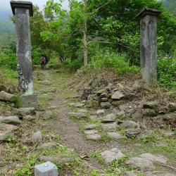
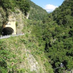
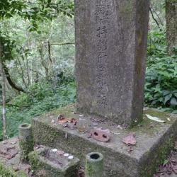
The Monument of the deceased Inspector in Charge Daigoro of Karenko (now Hualien County), is located at the foot of the Zhuilu section of the Hehuan Traversing Historic Trail, about 50 meters away from the Duan-ya Police Post.

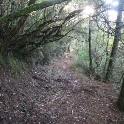
The monument was set up in memory of Inspector in Charge Daigoro of Donglu Checkpoint (later the checkpoint became Duan’ya police post), who was attacked and killed by indigenous people in 1916 while on duty. The monument was originally erected on a wooden pillar but was later converted into a cement tombstone in 1935. As the condition of the road that leads to the police post and the monument is poor, the monument is not open now.

Stone Buddha inside the small tunnel on Zhuilu Cliff
錐麓大斷崖小隧道內的石雕菩薩

Zhuilu Cliff is located on the Zhuilu section of the Hehuan Traversing Historic Trail. It is a steep cliff that was formed by the Liwu River cutting through the ridgeline of the mountain. It is about 1,200 meters long, 600 meters high and is mostly marble rocks. It faces the Fuji Cliff across the Liwu River, which is only around 20 meters away. It can even be called the most magnificent landscape in the Taroko Gorge.

When walking along the Zhuilu cliff, you will pass through a small tunnel. Inside the tunnel is a stone-carved Buddha, and the stone wall outside the tunnel is engraved with the words commemorating the excavation team who completed the project in 1915. The excavation project was led by Police Captain Umezawa Masa.

Small tunnel in the middle of Zhuilu Cliff
錐麓大斷崖中間小隧道的外觀

Zhuilu Cliff is located on the Zhuilu section of the Hehuan Traversing Historic Trail. It is a steep cliff that was formed by the Liwu River cutting through the ridgeline of the mountain. It is about 1,200 meters long, 600 meters high and is mostly marble rocks. It faces the Fuji Cliff across the Liwu River, which is only around 20 meters away. It can even be called the most magnificent landscape in the Taroko Gorge.

When walking along the Zhuilu cliff, you will pass through a small tunnel. Inside the tunnel is a stone-carved Buddha, and the stone wall outside the tunnel is engraved with the words commemorating the excavation team who completed the project in 1915. The excavation project was led by Police Captain Umezawa Masa.

Zhuilu Cliff
峭壁垂直陡立的錐麓大斷崖

Zhuilu Cliff is located on the Zhuilu section of the Hehuan Traversing Historic Trail. It is a steep cliff that was formed by the Liwu River cutting through the ridgeline of the mountain. It is about 1,200 meters long, 600 meters high and is mostly marble rocks. It faces the Fuji Cliff across the Liwu River, which is only around 20 meters away. It can even be called the most magnificent landscape in the Taroko Gorge.

Due to the steep terrain of the Zhuilu section of the historic trail, some sections of the road have collapsed. For safety purposes, only the section from the entrance to the Duan’ya police post (around 3.1 km) is currently open. If walking from the Zhuilu Suspension Bridge, it takes about 90 minutes to reach the most quintessential section of Zhuilu Cliff.

Badagang Police Post
巴達岡駐在所遺留的水泥門柱

The Badagang Police Post is located 1 km of the Zhuilu section of the Hehuan Traversing Historic Trail.  The terrain is gentle, but the cliff at the south edge of the mountain falls steeply.

Traditionally, it was a Turuku village of the Badagang group, which the traditional name of this place means makino bamboo. It also has the meaning of striking battlefield. According to records, in the past, the Badagang tribesmen temporarily moved to the lower reaches of Liwu River for refuge due to typhoon destruction. When they returned to their homes, they found that the land had been taken by the people from Jingguan Hamlet. They made spears from bamboos and fought back the land.

During the Japanese occupation, the Governor-General in Taiwan established a healthcare center, education center, and police post here. Later, guest houses, clubs, and dormitories were added in promoting the Taroko National Park project as a resting area between the route of Fushi and Tianxiang.

Budong Mingwang Temple
位於寧安橋下方的不動明王廟

The Budong Mingwang Temple is located on the 183 km point of the Central Cross-Island Highway, and sits under Ning’an Bridge. There are two bridges parallel to each other on Liwu River. The old red bridge was built when the road was first constructed. It was the longest one-lane bridge in Taiwan at that time. About 50 meters in front of the old bridge, there is a narrow Tianwang Bridge. Under this bridge there is a cave, and inside it is the Budong Mingwang Temple. It is said that it was a Japanese, who mined gold in Liwu River at the end of the Japanese Occupation, that brought the bronze statue of Fudo Myoo (Budong Mingwan or the immovable wisdom king) from Japan. The statue was enshrined here to protect the safety of the mining road construction. In the post-war period, the statue was sent to Xining Temple because there was no one to worship it in Liwu River. In 1951, Taipower rebuilt the statue, brought it back to Liwu and renovated the temple.


Wenshan Hot Spring
從泰山隧道俯視文山溫泉上方吊橋

Wenshan Hot Spring is located between Tianxiang and Xibao on the Central Cross-Island Highway. It is the only natural Hot Spring in Taroko National Park where water flows out from the crack of a marble rock on Dasha riverbed. It was discovered by Captain Fukami Buheiji during the Taroko War in 1914, and named it Fukami Hot Spring (Chinese character Shen-Shui, meaning deepwater). In the post-war period, the National Government changed its name to Wenshan Hot Spring. The trail on the right side of the south entrance of the Taishan Tunnel used to lead down to the hot spring. However, after a rock fell and injured some tourists in 2005, the trail has been closed since.

Guanyuan Police Post
關原駐在所入口處的的疊石牆

The Guanyuan Police Post is located above Guanyuan on the Central Cross-Island Highway, about 2,580 meters above sea level. When the Taroko War broke out, the army sent by the Government-General in Taiwan attacked the Turuku tribe from the east side of Hehuanshan. Guanyuan was the first stop, and when the then Governor of Taiwan, Sakuma Samata, heard that the Turuku tribe had fought here, he named the place after the ancient battleground during the Japanese Sengoku Period, “Sekigahara” (Guanyuan in Chinese character). As a result, the route of Hehuan Traversing Historic Trail was changed in the middle of the Japanese occupation, and the police post was called Guanyuan in honor of the Governor.

In the post-war period, the Central Cross-Island Highway was opened, passing through the small hamlet below Guanyuan Police Post, also known as Guanyuan. The hamlet has a lodge, Hehuan police station, and Guanyuan gas station.


Hehuan Traversing Historic Trail
從大禹嶺到關原駐在所之間的合歡越嶺古道

When the Taroko War broke out in 1914, the then Governor of Taiwan, Sakuma Samata, wanted to use a strong military and police force to defeat the Turuku tribe along the Liwu River. Therefore, Nantou Minister, Ishibashi Tooru, personally led the road excavation team, and opened the road from Puli to Tianxiang. After the war, the road continued to be opened from Puli to Taroko Gorge entrance, which was the original path of the Hehuan Traversing Historic Trail. Later, due to the collective migration of tribes and the steep slope of the original route, the route was modified and completed in 1935.

In the post-war period, the Central Cross-Island Highway was opened and replaced the Hehuan Traversing Historic Trail. Coupled with the erosion from typhoons, there are only a few complete road sections that can be walked on today.


Hehuan Police Post
從高處俯視合歡駐在所一帶的現況

The Hehuan Police Post is located above the Provincial Highway 14, between Dayuling and Xiaofengkou, at an altitude of 2,782 meters. When the Taroko War broke out in 1914, the then Governor of Taiwan, Sakuma Samata, wanted to use a strong military and police force to defeat the Turuku tribe along the Liwu River. Therefore, Nantou Minister, Ishibashi Tooru, personally led the road excavation team, and opened the road from Puli to Tianxiang. After the war, the road continued to be opened from Puli to Taroko Gorge entrance, which was the original path of the Hehuan Traversing Historic Trail. Later, due to the collective migration of tribes and the steep slope of the original route, the route was modified and completed in 1935. This route was a popular hiking trail at that time.