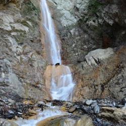
The Yinu Falls is located in Xinyi Township, Nantou County, with an altitude of about 1,750 meters. It is about 6.3 kilometers from the Dongpu Mountain entrance to the falls. The roads are often collapsed, so you can choose to go the detour route behind Lele Mountain Hut. The Yinu Falls is about 4 kilometers away from Duiguan police post.
The formation of Yinu Falls is due to the different degrees of resistance to weathering of each geological and lithological property, resulting in differential erosions. Similar to Yunlong Falls that hangs off the cliff wall, the Yinu falls is divided into several sections and winds down into Chenyoulan River. Yinu, or Otome in Japanese means girl in Japanese. It was given this name because the water falls gently and gracefully like a girl.
Bunun
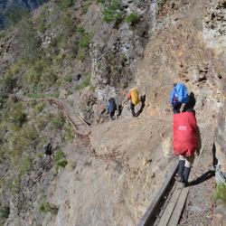
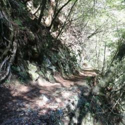
The image shows a section of the Batongguan historic trail that is about 10 minutes away from the Yinu Falls that leads to the Lele Mountain Hut. Although the Yinu Falls is only 500 meters away from the Lele Mountain Hut (former Lakulaku Police Post), the road condition is dangerous. The path is around one meter wide, and while there are iron chains and ropes on the mountain wall to assist tourists in hiking, Taiwan’s frequent earthquakes often loosen the rocks, causing landslides during heavy rain, which damages the plank roads. Due to the difficult maintenance of roads in the mountains, the Yushan National Park Management Office has established a safe detour route at the rear ridgeline of Lele Mountain Hut so that hikers can avoid crossing this dangerous area.
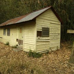
The Lele Mountain Hut is located at an altitude of about 1,696 meters, and is around 5.8 kilometers away from Dongpu and around 12.1 kilometers eastward from Batongguan. The hut was built on the foundation where the Lakulaku police post used to be during the Japanese occupation period. The Bunun called the area Oritu, meaning "mountain loquat" in the Bunun language, referring to the place with growing mountain loquats. There were no indigenous settlements near the police post, and since the Japanese planted cherry blossoms there, each year in April a cherry blossom festival is held there. A trail leading to Lele Hot Spring at the bottom of the Chenyoulan River is opened.RakuRaku in Bunun means hot spring. Today, fragments of wine bottles and dishes from the Japanese era can be found on site.
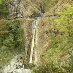
The Yunlong Falls is located in Xingyi Township, Nantou County, and is a tributary of Chengyoulan River and the upper stream of Lakulaku River. At an altitude of about 1,640 meters, it belongs to the Zhuoshui River Basin. The waterfall hangs on the rock wall next to the Batongguan historic trail, making it the most spectacular waterfall on the trail.
Coming from Dongpu you will pass the Fu-tzu cliff or the cliff of "Father Does Not Know Son". Due to the dangerous terrain and falling rocks, even when the father travels with the son together, they will not be able to take care of each other, hence the name.
The eastern section of Guanmen Historic Trail starts from Bazai Village to the ridge of Bazai Mountain, bypasses Xinglujun Mountain and Mahouwanshan, then goes up along the southeast ridge of Luntaiwen Mountain, After bypassing the top of Luntaiwen Mountain, it then descends steeply to Matai’an River, and then climb from the bottom of Matai'an River to the south three-section ridge line. Head north for another one kilometer you will reach the Guanmen Pond at the foot of Guanmen Mountain.
Mataian River originates from the north of Danda Mountain and is one of the tributaries of Hualien River. After the Guanmen Historic Trail crosses the highest point in the eastern section of the Luntaiwen Mountain, it first descends along the ridge to the west saddle of Luntaiwen, then goes down around two big ravines, and then descends along the northwest ridge to the upper reaches of Matai’an River at an altitude of 1,800 meters. On the lower stream, there is a wide flat land, where the camp of Qing army was stationed. There are seven red cypress trees that are more than 15 meters tall and so it was called "Giant Tree Camp Site". The stream there is crystal-clear, knee-deep, and there are white boulders everywhere with lush forests on both sides of the stream, making it very peaceful.
Bazaishan is located in Wanrong Township, Hualien County, above the Fuyuan National Forest Recreation Area, at an altitude of 1,755 meters. It is the first mountain to reach from the east section of Guanmen Historic Trail.
Looking west from Fuyuan Railway Station in the early morning, you can clearly see Bazaishan, which is the mountain top in the mist on the left side in the photo. However, it is usually cloudy and covered in the afternoon. Bazaishan is rich in ecology. The Fuyuan Forest Recreation Area at the foot of the mountain is a well-known place for viewing butterflies. Especially from March to August every year, you can see more than 30 kinds of butterflies such as the common bluebottle, hebomoia glaucippe formosana, and minois dryas.

Shuanglong Village is located in the northern part of Xinyi Township. It is adjacent to Dili Village and Zhuoshui River in the north, the central mountain range and Hualien County in the east, and Dongpu Village and Renhe Village in the south. Originally a part of Renhe Village, Shuanglong village was officially established in September 1958, when the northern and northeastern parts of the original Renhe Village expanded.
Today, the residents of Shuanglong Village are mainly composed of old Bunun tribes such as Iskan, Lafflang, and Qanituan. From Dili Village on Provincial Highway 16, you can cross the Zhuoshui River to the south to reach the village. The environment is peaceful and quiet. Walking in the village, you can see creative wall sculptures everywhere, telling the history of Shuanglong and Bunun culture. Shuanglong Elementary School is the earliest building with character and is also the first building in the country to have indigenous cultural connotations.
Zhongzhiguan Historic Trail is located between Zhongzhiguan and Tianchi on the Southern Cross-island Highway in the Taoyuan District of Kaohsiung City. It is one of the sections of the Guanshan Historic Trail that is relatively intact. During the Japanese occupation, the Governor-General in Taiwan decided to expand the passage between hamlets located along Xinwulu River and the Laonong River in order to regulate the indigenous peoples. At the same time, construction began at both ends of the Kaohsiung State and Lilong County, excavating towards the Central Mountain Range. The Guanshan Historic Trail was completed in 1931. Today, the Southern Cross-island Highway runs almost along the Guanshan Historic Trail. Among which, there is a 3.5-kilometer-long section of historic trail between Zhongzhiguan and Tianchi that is relatively intact and is called Zhongzhiguan Historic Trail.
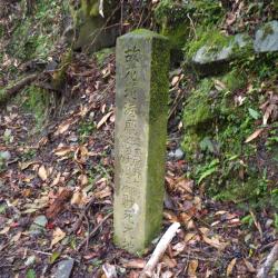
The Monument of the Death of Inspector Miyano, Oshima and Government Official Kasau of Karenkou Prefecture is located beside the Batongguan Traversing Historic Trail, about 1,900 meters above sea level, south of Pengke Police Post, and about 1.8 km away from Eshira Police Post. Originally, there were three wooden pillars erected to commemorate two officers and one government official who were ambushed and killed during their duty on March 16, 1921. It was later converted into one reinforced concrete obelisk-shaped monument in the mid-Japanese occupation period in the 1930s.