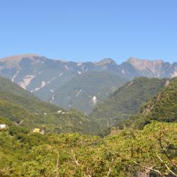
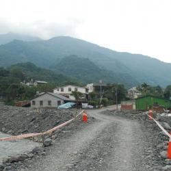
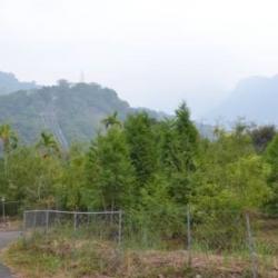
The Xiama Hamlet is located in Wulu Village, Haiduan Township, Taitung County, close to the top of the Southern Cross-island Highway, on a slope about 700 meters above sea level. The hamlet was originally located on a hillside about 1 km southeast of the present site and was formed under the Japanese government's forced relocation after the middle of the Japanese occupation. In the Bunun language, this place is called Vauvu, which means spine. It got its name because the mountain looks like a spine from a distance. There are only four Bunun families who originally lived near Vauvu. The Japanese named the place Ivaqo, set up a police post in the area to rule, and began to ask the Bunun people that were living scattered in the adjacent mountainous area to migrate to Ivaqo. In the late Japanese occupation period, Xian became a small settlement of about 10 households. In 1975, due to the collapse of the foundation caused by the typhoon, the government moved the residents from the old hamlet to the present location.
Hamlet
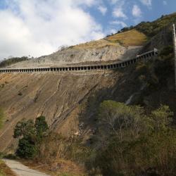
The Morakot typhoon in 2009 caused subgrade collapse, road surface burial, and broken bridges on the Southern Cross-island Highway. The repair work was extremely difficult. Although the Meishanming Tunnel above the Meishan hamlet did not suffer major damage during the Morakot typhoon, it was damaged by heavy rain in August 2014. A large-scale collapse crushed the Tunnel, and it was not repaired until September 2018. Since the hamlet is the entrance to the mountainous area in the western section of the highway, the restoration of the Meishanming Tunnel was an important indicator of whether the Southern Cross-island Highway can be opened to traffic.
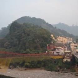
Meishan Hamlet (Masuhuaz) is located in Meishanli, Taoyuan District, Kaohsiung City. In the Bunun language, it is called Masuhuaz, which means rattan (Calamus jenkinsianus), and it got its name because the area is rich in this kind of rattan. The site of the old Masuhuaz community is above the current hamlet. After moving to the current site in 1961, it was still called Masuhuaz. The name was changed to Meishan after the national government moved to Taiwan because of the abundant plum trees in the area. The Morakot typhoon in 2009 caused subgrade collapse, road surface burial, and broken bridges on the Southern Cross-island Highway. The repair work was extremely difficult. Although the Meishanming Tunnel above the Meishan hamlet did not suffer major damage during the Morakot typhoon, it was damaged by heavy rain in August 2014. A large-scale collapse crushed the Tunnel, and it was not repaired until September 2018. Since the hamlet is the entrance to the mountainous area in the western section of the highway, the restoration of the Meishanming Tunnel was an important indicator of whether the Southern Cross-island Highway can be opened to traffic.
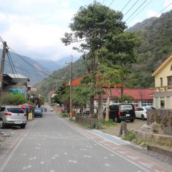
The abolished Fuxing Police Station was the Bibiwu Police Post on the Guanshan Historic Trail during the Japanese occupation, and behind it was the Fuxing Branch of Zhangshan Elementary School. The Bibiwu Station was originally located on the west bank of the Laonong River, but was later moved to the site of the Fuxing Police Station on the east bank for reasons of precaution. The Fuxing hamlet (Uaasik) is located in Fuxingli, Taoyuan District, Kaohsiung City. In the Bunun language, it is called Uaasik, which means a place that grows palms because there are many wild mountain palms here. The locals are more accustomed to using the Japanese translation of Bibiuw (bibiyoshe or Bibiwushe). The people originally lived scattered among the mountains and forests. During the Japanese colonial period, the Japanese implemented the policy of managing the indigenous peoples and forced the relocation of the tribe to concentrate on the left bank of the Laonong River, which is the platform about 2 kilometers east of the confluence of the Laonong River and the Lakesi River. At the end of the Japanese occupation, malaria broke out in the villages, causing the people to migrate, and the population dropped sharply. It was not until after the liberation that the malaria epidemic slowed down that the population gradually returned. At present, people mainly live near the present Fuxing Police Station. Since this hamlet is further away from the Southern Cross-island Highway, the settlements are scattered and small in scale.
The Fuxing hamlet (Uaasik) is located in Fuxingli, Taoyuan District, Kaohsiung City. In the Bunun language, it is called Uaasik, which means a place that grows palms because there are many wild mountain palms here. The locals are more accustomed to using the Japanese translation of Bibiuw (bibiyoshe or Bibiwushe). The people originally lived scattered among the mountains and forests. During the Japanese colonial period, the Japanese implemented the policy of managing the indigenous peoples and forced the relocation of the tribe to concentrate on the left bank of the Laonong River, which is the platform about 2 kilometers east of the confluence of the Laonong River and the Lakesi River. At the end of the Japanese occupation, malaria broke out in the villages,causing the people to migrate, and the population dropped sharply. It was not until after the liberation that the malaria epidemic slowed down that the population gradually returned. At present, people mainly live near the present Fuxing Police Station. Since this hamlet is further away from the Southern Cross-island Highway, the settlements are scattered and small in scale.
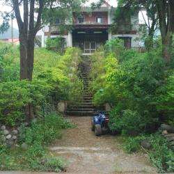
The image of a new community, Fuxing village, was taken from Tianleng. The path on the left side of the settlement is the forest railway that was used in the former Basianshan Forest Farm, leading to Basianshan.
Baxianshan Forest Farm was one of the three major forest farms in Taiwan during the Japanese occupation. The logging of the forests began in November of the 4th year of Taisho (1915). In the 5th year of Taisho (1916), the Forestry Bureau of the Taiwan Governor set up a Basianshan branch office in Jiabaotai that ministered to various businesses. Afterward, after various transfers, in Showa 17 (1942), Taiwan Takushu Co., Ltd. was transferred to become a government-business joint venture. After the war, the logging business continued in this field, and the production volume exceeded the sum of the Japanese occupation period by the mid-1950s. In 1963, the forest farm stopped production. At present, Basianshan is under the Dongshi Forest Area Management Office of the Forestry Bureau.
Basianshan was named in October of Meiji 43 (1912), when Uichiro, Uchida Koshiro and others came here to fight against the indigenous peoples. Since the height of the mountain was 7998 Japanese feet and was almost 8,000 feet, it was named "Eight Thousand Mountains" (Hatsusensan). This is homophonic for "Eight Immortals Mountain" (Basianshan). Basianshan and its surrounding mountainous areas are rich in forest resources and became one of the three largest forest farms in Taiwan during the Japanese colonial period. The logging of the forests began in November of the 4th year of Taisho (1915). In the 5th year of Taisho (1916), the Forestry Bureau of the Taiwan Governor set up a Basianshan branch office in Jiabaotai that ministered to various businesses. Afterward, after various transfers, in Showa 17 (1942), Taiwan Takushu Co., Ltd. was transferred to become a government-business joint venture. After the war, the logging business continued in this field, and the production volume exceeded the sum of the Japanese occupation period by the mid-1950s. In 1963, the forest farm stopped production. In 1978, it was established as the "Basianshan Forest Recreation Area", covering the 99th-102nd, 108-111 forest classes of the Basianshan business area, and became a well-known tourist spot in central Taiwan.
The Atayal people of Hrung originated from the Ruiyan hamlet (qalangMsthbwan) in Renai Township, Nantou County, and then migrated to the Tebirun River (gong Tebirun) and the Baigou Mountain, and established qalangPesyux hamlet, where Dajia River meets the tributary Piyasan River (gong Piyasan). Later, the people moved to Qingshan (ulayrim). According to the elder’s memory, in the 1920s, when he lived in the qalangPesyux hamlet, he was invaded by the Wushe Seediq tribe and moved to qalangPyasan. In the 1930s, he moved to qalangHrung. During the Japanese occupation period, the education center taught the people to wrestle and sumo. In the annual sumo competition, the Hrung and Songhe hamlets once had players that got five and three consecutive victories and won the overall championship for the team. In the history of local self-government after the war, the number of households in Hrung and Songhe hamlets was small, only 50 or 60 households.
This Baileng Police Post can be seen from the 1/50,000th topographic map of the Japanese rule during the Showa period. It was the predecessor of the Supervisory Office on the Baileng Aiyong Boarder, where there is a patrol defile, which was excavated on February 23, Meiji 44 (1911). The route starts from the Beileng Supervisory Office, going up the Dajia River and arriving at the シウワンタイム, with a total length of about 4 miles (about 16 kilometers). In the 3rd year of Taisho (1914), because the original old defile was very narrow, Taichung Office planned to widen the road from Dongshijiao to Baxianshan to facilitate the logging business. It was finally excavated by the Forestry Bureau of the Governor's Office of Taiwan, but the road still ended at Kurasu (now Songhe, Heping District, Taichung City).
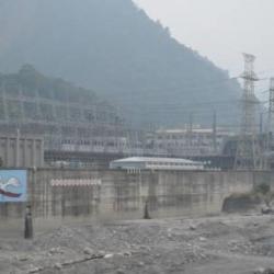
The Tianlun Branch of the Dajia Power Plant is the administrative and remote control center of each power plant in the Dajiaxi River Basin. Due to the steep slope of the Dajia River and many passes, in Showa 17 (1942), the Land and Resources Bureau of the Taiwan Governor's Office formulated the "Dajia River Development Project" and planned to build a weir on the upper reaches of the Dajia River to store water for development and to meet the goals of providing water for agricultural irrigation and industrial water usage through power generation and flood regulation. Among them, Taiwan Electric Power Co., Ltd. set up 6 power generation fortifications downstream of the barrier for generating power. The other facilities, such as transportation, are the responsibility of the land bureau. However, the plan was interrupted by the defeat of Japan. After the war, the nationalist government followed the Japanese plan, and this power development plan was still centered on Dajian, with 6 power plants including Dajian, Qingshan, Guguan, Tianlun, Maan, and Shigang.