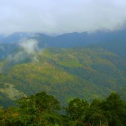
Basianshan was named in October of Meiji 43 (1912), when Uichiro, Uchida Koshiro and others came here to fight against the indigenous peoples. Since the height of the mountain was 7998 Japanese feet and was almost 8,000 feet, it was named "Eight Thousand Mountains" (Hatsusensan). This is homophonic for "Eight Immortals Mountain" (Basianshan). Basianshan and its surrounding mountainous areas are rich in forest resources and became one of the three largest forest farms in Taiwan during the Japanese colonial period. The logging of the forests began in November of the 4th year of Taisho (1915). In the 5th year of Taisho (1916), the Forestry Bureau of the Taiwan Governor set up a Basianshan branch office in Jiabaotai that ministered to various businesses. Afterward, after various transfers, in Showa 17 (1942), Taiwan Takushu Co., Ltd. was transferred to become a government-business joint venture. After the war, the logging business continued in this field, and the production volume exceeded the sum of the Japanese occupation period by the mid-1950s. In 1963, the forest farm stopped production. In 1978, it was established as the "Basianshan Forest Recreation Area", covering the 99th-102nd, 108-111 forest classes of the Basianshan business area, and became a well-known tourist spot in central Taiwan.
Atayal
The Atayal people of Hrung originated from the Ruiyan hamlet (qalangMsthbwan) in Renai Township, Nantou County, and then migrated to the Tebirun River (gong Tebirun) and the Baigou Mountain, and established qalangPesyux hamlet, where Dajia River meets the tributary Piyasan River (gong Piyasan). Later, the people moved to Qingshan (ulayrim). According to the elder’s memory, in the 1920s, when he lived in the qalangPesyux hamlet, he was invaded by the Wushe Seediq tribe and moved to qalangPyasan. In the 1930s, he moved to qalangHrung. During the Japanese occupation period, the education center taught the people to wrestle and sumo. In the annual sumo competition, the Hrung and Songhe hamlets once had players that got five and three consecutive victories and won the overall championship for the team. In the history of local self-government after the war, the number of households in Hrung and Songhe hamlets was small, only 50 or 60 households.
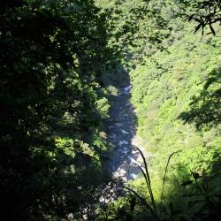
This Baileng Police Post can be seen from the 1/50,000th topographic map of the Japanese rule during the Showa period. It was the predecessor of the Supervisory Office on the Baileng Aiyong Boarder, where there is a patrol defile, which was excavated on February 23, Meiji 44 (1911). The route starts from the Beileng Supervisory Office, going up the Dajia River and arriving at the シウワンタイム, with a total length of about 4 miles (about 16 kilometers). In the 3rd year of Taisho (1914), because the original old defile was very narrow, Taichung Office planned to widen the road from Dongshijiao to Baxianshan to facilitate the logging business. It was finally excavated by the Forestry Bureau of the Governor's Office of Taiwan, but the road still ended at Kurasu (now Songhe, Heping District, Taichung City).
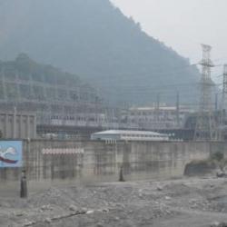
The Tianlun Branch of the Dajia Power Plant is the administrative and remote control center of each power plant in the Dajiaxi River Basin. Due to the steep slope of the Dajia River and many passes, in Showa 17 (1942), the Land and Resources Bureau of the Taiwan Governor's Office formulated the "Dajia River Development Project" and planned to build a weir on the upper reaches of the Dajia River to store water for development and to meet the goals of providing water for agricultural irrigation and industrial water usage through power generation and flood regulation. Among them, Taiwan Electric Power Co., Ltd. set up 6 power generation fortifications downstream of the barrier for generating power. The other facilities, such as transportation, are the responsibility of the land bureau. However, the plan was interrupted by the defeat of Japan. After the war, the nationalist government followed the Japanese plan, and this power development plan was still centered on Dajian, with 6 power plants including Dajian, Qingshan, Guguan, Tianlun, Maan, and Shigang.
The hamlet is on the east side of the Nanshi hamlet, on the high ancient river terrace on the right bank of the Dajia River. The terrain is high and flat, and prehistoric stone tools can be collected from the surface of farmland. The residents came from Songhe hamlet after the 72 floods in 2004. In addition to the Atayal, the residents also include Hokkien, Hakka, Amis, and other ethnic groups.
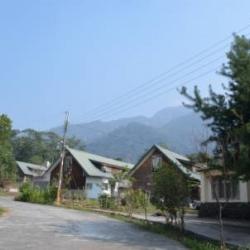
The Typhoons Mindulle and Aere in July and August 2004 hit Songhe hamlet, causing all 78 households to collapse. The county government and the office urgently placed the affected households in the Indigenous Arts Center. Because some areas of the Songhe Hamlet were listed as dangerous areas and could not be rebuilt, the government allocated 0.9 hectares of the land of the Indigenous Arts Center and had the Red Cross build 40 houses to resettle the Songhe victims.
The original name of Heping is "Shaolaiping", which is a narrow river terrace on the right bank of Dajia River. The name came about after the "Shaolaishe" community moved here. Shaolaishe originally lived scattered in the northwestern part of Dongmao Mountain and the foothills on the west bank of Dongmao River. Later, due to a lack of cultivated land, the people moved to Misara.
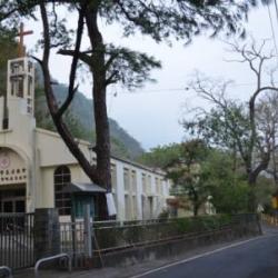
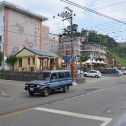
In the 39th year of Meiji, due to the ruling requirement, people were moved to the current place of residence. At the beginning of the move, there were 6 households with 23 people; In the 5th year of Showa (1930), two communities (Baimao and Baimao Aleng) were merged Nansei community. After the war, the Heping Township Office was moved here from Boai, and the name "Heping" gradually replaced the old Xiaolaiping. Heping is the administrative center of the district, where most of the agencies in the district are concentrated, such as the township representative assembly, police station, fire brigade, household registration office, peasant association, junior high school, library, and so on.
Kngungu is an ancient tribe of Klesan. According to the oral tradition of its migration, each tribe left the ancient tribe of habun Kolo and went east to Piahaushe. This settlement was later established as a permanent hamlet by the Mabaala people and continued until the 1930s. While the Kana-Xaqual people crossed Piahaushe, went alond the north Heping River towards the east and settled in Moyao, Kngungu and other places.
Later, they moved away from the land of Kngungu to the north (upward along the mountain ridge) around 1,000 kilometers above sea level and gradually established settlements Jinyangshe, Kigayangshe, Kubabo, Kelumuo’anshe, Hagawan, Hagaparis, Tabera, Lahau and Klgyah. The Kana-Xaqual people exhibit a continuous linear community diffusion, making them an important ancient tribe for the spread of the Squliq language.
Ryohen-she is located on the slope facing east, the ridge line between Buxiaowan River and Ryohen (Kong Sawsi) River, a tributary of north Heping River, at an altitude of about 1,000 meters. The area is open, sunny, and suitable for living. The residents believe that their ancestor Bato Naui set out from pinsəbəkan together with Wasau Payas, crossed the Nanhu Mountain and arrived at habun kolo, where Bato stopped and settled. Wasau Payas and his tribe carried on moving eastward to kngungn (south of old Jinyangshe, Linxi Platform), where Wasau died. The tribe later moved to Tbunan, a platform by the river terrace on the right bank of the Buxiaowan River estuary.
Decades later, due to the increase in population, the tribe migrated to three different places, namely Ryohen-she, which was lead by the then leader Takun Bakotsi. They went up along the Ryohen River to the mountainside to establish the settlement. The other group traveled northward for about one kilometer to establish Gogotsu-she, while the third group, led by Meraaran, established the Rəkinos-she near Gogotsu-she.
"Bbu" means "a place with a good view from the platform on the mountain" in the Atayal language. From the name, it is clear how the terrain of this hamlet is like. The hamlet is located at the intersection of the left bank of the north Heping River and the Mohen River, at an altitude of about 1,200 meters. The Japanese Occupation Security Road passes below the hamlet, leading to Liuxingshe in the east and Jinyangshe in the west. There is an Education Center for indigenous children and a fort in Kubaboshe. At present, the school playground, the command platform, and the drainage ditch can still be seen in the hamlet.
In the early days, traditional Atayla house was used as the official’s office. Later in the first year of the Showa era (1926), the Japanese built the Kubabo police post using cypress wood. However, there are no traces of the wooden structure of the building any more, only huge stacked stone foundations remain.