Atayal

Lalashan Police Post Entrance
拉拉山駐在所入口景館

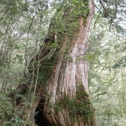
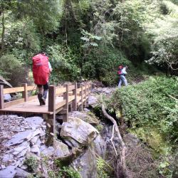
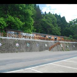
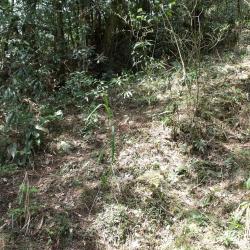
The Lalashan Police Post was established in the 11th year of Taisho (1922) and abolished in June of the 35th year of the Republic of China (1946). The site is located at 11.5K of Fuba Cross-ridge Historic Trail, about 2 hours' walk from the Sacred Trees area of ​​Lalashan. The site is a wide three-story platform. On the platform, there are abandoned hunting huts, some broken bowls and glass bottles left over from the Japanese occupation period. Many stacked stone walls can also be found around. There is a slope at the entrance of the site, which is overgrown with weeds. The image is a view taken from the historic trail to the entrance slope.


Sacred Tree
福巴越嶺古道上聳立參天神木

There are many sacred trees scattered along the trail between Lalashan and Guishan Police Post, as well as the Lalashan sacred trees at the Baling Mountaineering Entrance. 

The altitude of this area is between 1,300 and 1,700 meters, and the climate is suitable for the growth of cypress forests. The sacred tree in the image is located between the Guishan Police Post and the Lalashan Police Post.

Path leading to Jiaobanshan Shrine
角板山神社參拜道

The slope in the distance was the route leading to Jiaobanshan Shrine during the Japanese occupation. The building on the left side of the slope is the Taoyuan City Fuxing District Library, and on the right is the Fuxing District History and Culture Museum. The Jiaobanshan Shrine was built in Jiaobanshanshe, an indigenous community in Daxi County, Hsinchu Prefecture. It was erected on August 15 in the 13th year of the Showa era (1938), and the deity was dedicated to the God of Harvest and Prince Kitashirakawa Yoshihisa. The original site is located near the intersection of Zhongzheng Road and Renai Road in Zerenli, Fuxing District, Taoyuan City. After the war, the shrine was demolished, and only the "poles" (the long column from the lower part of the stone lantern) of stone lanterns remain, which are now used as decoration beside the stairs. The names of the donors are still visible on the stand.

Bridge on the route between Quan Police Post and Zhen Police Post
泉駐在所通往榛駐在所途中溪溝木橋

The image shows the wooden bridge on the way from the Quan Police Post to the Zhen Police Post, and the creek that is located about 35 minutes way from the Quan Police Post. The Sheipa National Park built a wooden bridge here around 2003. After the wooden bridge, it takes about 30 minutes to reach the Zhen Police Post.

Xianbi Hamlet
影像為麻必浩部落空拍象鼻部落,右方伸入大安溪稜線為千兩山稜線,其稜線後方部落為後方部落為象鼻部落。

Xianbi Hamlet is located at the foot of the mountain on the right bank of Da'an River, on the platform about 500 meters above the sea. Originally named Mepuwal and belonged to the members of the community from the Beishi group of the Atayal Zeolia tribe. Their ancestors were the old Malabang community, which fought against the Japanese in Meiji 36 (1903), and retreated here from Dongxing Village, Dahu Township. The origin of the village name was named after the location, Qianliang Mountain, which looks like an elephant's trunk. In the 13th year of Taisho (1924), the Xianbi Police Post was set up at the commanding height behind the hamlet.

Da'an Hamlet
影像為空拍大安溪左岸的大安部落

The Da'an hamlet belongs to Xiangbi Village, Tai'an Township, Miaoli County. It is located on the left bank of Da'an River, at the north foothills of Ma'an Mountain, on a platform about 500 meters above sea level. The residents of the Da'an hamlet are composed of residents from the Beishi Group and the Jialapai Group of the Atayal tribe. Residents from the Beishi Group are remaining survivors from rebelling against the Japanese in 1910, who were induced by the official government to move here. The Residents from the Jialapai Group were moved across the Da'an River after the Wushe incident.

Da'an River Meixian Bridge
影像前方橋樑為連結梅園村及象鼻村的梅象橋

The bridge in the image is the Meixian Bridge that connects Meiyuan Village on the left and Xianbi Village on the right. It is about 700 meters above sea level and is at the junction of Taichung City and Miaoli County. The Da’an River Basin gradually forms a canyon from the upstream of Meixian Bridge, where the Xuejian Hot Spring is located at 18.5 kilometers upstream. Xuejian Hot Spring is on an altitude of about 1,020 meters, and the one-way journey takes about 9 hours. Xuejian Hot Spring a geothermal spring. The hot water and steam are in a high pressure state, and pass through the fissures of the stratum to the surface, forming the Xuejian Hot Spring.

Meiyuan Hamlet
梅園部落

The Meiyuan hamlet is located in Meiyuan Village, on the right bank of Da’an River, at the southwest foothills of Jinwei Mountain, on a platform about 500 meters above sea level. The name of the tribe is Maylubung, which was named after the pool that draws drinking water for the tribe. Therefore, there is a pond on the land. The place is small and the terrain is low. After the war, due to the local planting of a large number of plum trees, the National Government named it Meiyuan (plum garden), which is the current name. In August 1963, Typhoon Geleri struck, and the flood washed away most of the tribe's farmland. Therefore, some tribes moved to settle in Heping Township of Taichung County, yet many people returned to settle here.

Guanwu Lodge
影像為伐林時代的林務局觀霧宿舍,原為日治時期モギリ(茂義利)駐在所的舊址,現為一排米黃色的建築,分別為林務局工作站、觀霧山莊,提供遊客住宿及餐飲服務。

Maoyili (Japanese: Mogili) Police Post is located in the 8th alley of Meiyuan Village, Taian Township, Miaoli County. Mogili means a high hill in Atayal language. It was named Mogili because it is located at the junction of Miaoli and Wufeng Township, and it was a watershed with high terrain.  In the 12th year of Taisho (1923), the Maoyili Police Post was established. After the war, the Forestry Bureau was engaged in logging and afforestation. Because it is located on the ridge line of the Luchang Mountain at an altitude of 2,200 meters, when the northeast monsoon comes in winter, it often leads to thick fog. Therefore, it was called Guanwu (viewing fog). Originally a state-owned forest land, the Forestry Bureau has set up a workstation, a guest house, a material transportation management station, and later set up a Guanwu National Forest Recreation Area. Since the site is located in the Sheipa National Park, it also has a National Park Visitor Center.

Tiangou Hamlet
影像為俯拍天狗部落

The Tiangou hamlet is located in the 3rd to 6th alley of Meiyuan Village, Tai'an Township, Miaoli County, in the northeast of Da'an, and on the terrace on the right bank of the Da'an River.  The Atayal people call it Saulau (or Vai-annuh, Mai-annuh), which means soil that can be dyed, sa means to dye, and ulau means land. It’s got the name because there are earth-colored, earth-yellow and red soils in the local area and were used as a source of dyeing pigments. It is also also called Vai-annuh, which means flat in the local Atayal language.  The people originally lived in the Jinwei mountain area on the east side of the current location. During the Japanese occupation period, in the Taisho period, due to the implementation of the group relocation plan, they were moved to the current place to live. As the ridgeline looks like a crouchingdog and because of its high terrain, it was give the name, Tiangou. From the mid-1930s to 1937, some members of the Yehmagong comunity were moved to the Tiamgou settlement by the Japanese.