Coastal Mountain Range

Dewu River Terrace
從遠處眺望德武河階

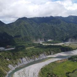
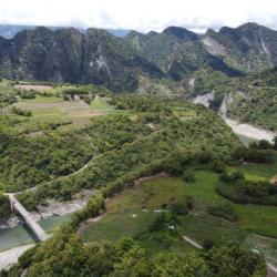
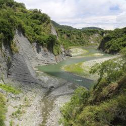
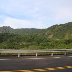
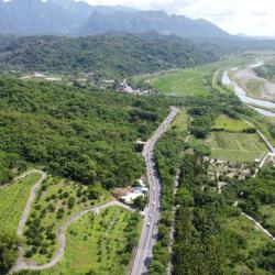
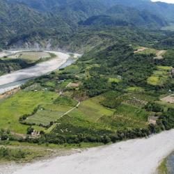
Dewu River Terrace is located on the east side of the confluence of Xiuguluan River and Fuyuan River in Ruisui Township, Hualien County. It is the starting point where Xiuguluan River cuts through the coastal mountains. 

The traditional name is Lulnu, which means paper mulberry because in the past, there were many wild paper mulberry trees here. It is also an area where the Amis people do dry farming and grazing. Overlooking from the Ruigang Industry Road, it is clear that the Dewu River Terrace descends from south to north. This shows that the river is continuously migrating to the north during the downward cutting process, which results in asymmetric growth meanders on both sides of the river bank. In addition, there is a prehistoric cultural site on the hillside of the Dewu River Terrace as fragments of plain pottery from the Jingpu hamlet have been found. This presumes that this was where the Amis people lived in the early days.


Houzi Shan (Monkey Mountain)
從瑞港公路眺望猴子山

Houzishan (Monkey Mountain) is a river terrace along the Xiuguluan River that is located on the east side of the Dewu river terrace in Ruisui Township, Hualien County. Its traditional name is Kawasan, which means a place where gods and ghosts appear. Therefore, it is also called Ghost Mountain. It is said that macaques came here to forage in the past. Xiuguluan River is the largest river in eastern Taiwan, with a total length of about 104 km. In the process of cutting through the coastal mountains, many steep canyons have also been formed, resulting in developed meanders and river terraces, such as Dewu River Terrace, Monkey Mountain, and Chimei River Terrace. This makes an excellent classroom for observing geology or topography.

Xiuguluan River
從奇美部落往西眺望秀姑巒溪,右下為奇美河階

The Xiuguluan River begins from the Central Mountain Range. It runs north along the Huadong Rift Valley, and turns eastward at Ruisui Township in Hualien County. Then it cuts across the coastal mountains and finally flows into the Pacific Ocean at Dagangkou (Cepo’) Hamlet. It is the largest river in eastern Taiwan with a total length of about 104 km. Also, it is the only river in Taiwan that cuts through the coastal mountains. During the process of cutting through the coastal mountains, the Xiuguluan River also cuts many steep gorges, resulting in some quite developed meander and river terraces, such as Dewu River Terrace, Monkey Mountain, and Chimei River Terrace. This makes an excellent classroom for observing geology or topography.

Chimei (Kiwit) River Terrace
奇美河階西側的地層結構,奇美部落即位於此河階面上

Chimei River Terrace of Ruisui Township, Hualien County, is located at the confluence of the Xiuguluan River and Chimei River. The single-sided mountains, circulation mounds and river terraces in this area are quite developed, and the Chimei Hamlet is located on the platform of this river terrace. Chimei River was originally a turbid current that entered the sea. But during the uplift of the coastal mountains, it continued to erode toward the source, which changed its course and converged into the current Xiuguluan River. In addition, the Chimei Fault is the most important active fault in the coastal mountains, with a total length of more than 30 km. The stratigraphic structure of the Chimei River on the west can be seen from Ruigang Industry Road.

Sugar Refinery
安通越嶺古道東段製糖所位置,現已無任何痕跡

The Yu-Chang Highway, which runs through Hualien County and Taitung County, was excavated in 1875. The highway stretches mainly along the Antong Valley and deep into the coastal mountains. After passing through a tunnel, it then follows the road between the Lujiao Creek and Ningpu Creek that leads to Ningpu Village in Changbin Township. The construction of the Yu-Chang Highway was actually based on the Antong Traversing Historic Trail. At that time (Qing period), General Wu Guangliang, who was stationed in Yuli, led the soldiers to excavate Pushige Chengguang’ao passae. This became the outer port of the middle section of the Huadong Rift Valley on the other side of the Coastal Mountains.

During the Japanese occupation period, the Government-General in Taiwan revised the legislation and changed the route to go from Antong to Zhuhu. In the post-war period, the Nationalist Government built a road from Yuli to Changbin, and chose the same route as the Antong Traversing Historic Trail. This road was completed and opened to traffic in 2007.


Historic Trail
位於海拔380公尺稜線上的安通越嶺古道東段

The Yu-Chang Highway, which runs through Hualien County and Taitung County, was excavated in 1875. The highway stretches mainly along the Antong Valley and deep into the coastal mountains. After passing through a tunnel, it then follows the road between the Lujiao Creek and Ningpu Creek that leads to Ningpu Village in Changbin Township. The construction of the Yu-Chang Highway was actually based on the Antong Traversing Historic Trail. At that time (Qing period), General Wu Guangliang, who was stationed in Yuli, led the soldiers to excavate Pushige Chengguang’ao passae. This became the outer port of the middle section of the Huadong Rift Valley on the other side of the Coastal Mountains.

During the Japanese occupation period, the Government-General in Taiwan revised the legislation and changed the route to go from Antong to Zhuhu. In the post-war period, the Nationalist Government built a road from Yuli to Changbin, and chose the same route as the Antong Traversing Historic Trail. This road was completed and opened to traffic in 2007.


Wumaozi Mountain Ridge
從玉長公路上遠眺安通越山和烏帽子山之間的稜線

The Yu-Chang Highway, which runs through Hualien County and Taitung County, was excavated in 1875. The highway stretches mainly along the Antong Valley and deep into the coastal mountains. After passing through a tunnel, it then follows the road between the Lujiao Creek and Ningpu Creek that leads to Ningpu Village in Changbin Township. The construction of the Yu-Chang Highway was actually based on the Antong Traversing Historic Trail. At that time (Qing period), General Wu Guangliang, who was stationed in Yuli, led the soldiers to excavate Pushige Chengguang’ao passae. This became the outer port of the middle section of the Huadong Rift Valley on the other side of the Coastal Mountains.

During the Japanese occupation period, the Government-General in Taiwan revised the legislation and changed the route to go from Antong to Zhuhu. In the post-war period, the Nationalist Government built a road from Yuli to Changbin, and chose the same route as the Antong Traversing Historic Trail. This road was completed and opened to traffic in 2007.


Entrance of Yu-Chang Highway
從空中俯瞰玉長公路從安通進入海岸山脈的入口

The Yu-Chang Highway, which runs through Hualien County and Taitung County, was excavated in 1875. The highway stretches mainly along the Antong Valley and deep into the coastal mountains. After passing through a tunnel, it then follows the road between the Lujiao Creek and Ningpu Creek that leads to Ningpu Village in Changbin Township.

The construction of the Yu-Chang Highway was actually based on the Antong Traversing Historic Trail. At that time (Qing period), General Wu Guangliang, who was stationed in Yuli, led the soldiers to excavate Pushige Chengguang’ao passage. This became the outer port of the middle section of the Huadong Rift Valley on the other side of the Coastal Mountains. During the Japanese occupation, the Government-General in Taiwan renamed the place Hongzuo Traversing Trail. Later, when the route was changed from Antong to Zhuhu, the trail was renamed to Antong Traversing Trail.