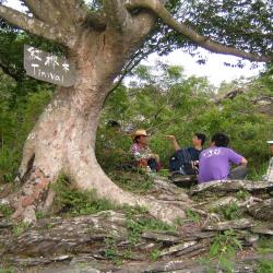
The Taiwan beech (Tinivai) resting platform is located at the entrance of the old Haocha village at an altitude of about 830 meters. There is a Taiwan beech with a thick trunk of about 1 meter in diameter and a height of 6 meters. There are stacked slate stools under the tree. The platform faces the valley, overlooking the South Aliao River. Today, the Taiwan beech (Tinivai) is an important landmark on the way to the old village for the tribesmen. Before migrating away from the village, it was also the resting place between old Haocha and the plains in the west. It takes about an hour and a half to go from the Taiwan beech to old Haocha. After passing the resting place, you can see the village in the distance.
Rukai
Carved eave by Lidaku
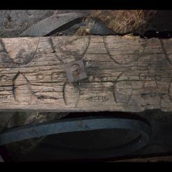
The image is of carved eaves in front of the house of Lidaku Mabaliu (1902-1990), who was the most well-known sculptor and blacksmith of the Haocha village in modern times. To protect it from being damaged by wind and rain, it is currently tucked away inside a slate house in the village that has a complete roof. The head pattern carved on these eaves can resemble the head of Lidaku as he intentionally or unintentionally projected part of himself in the works. After moving away from old Haocha village, Lidaku was the first to have returned to rebuild his hometown. He was a living dictionary that witnessed the rise and fall of the Haocha village in the past century and is a typical representative of the Rukai tradition and modern society.
Rinari Village
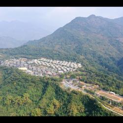
Rinari Village in Majia Township, Pingtung County, is located on a plateau stretching from northeast to southwest. It was originally the Majia Farm that belonged to Taiwan Sugar Corporation. Due to Typhoon Morakot in 2009, many villages in the mountainous area of Pingtung were facing safety issues. Therefore, under the plan of the National Government, Majia Village, Haocha Village and Dashe Village, which were adjacent to Majia Farm, were collectively relocated to the farm for resettlement. World Vision then assisted in the construction of permanent houses for those residents. A total of 483 houses were built, and after a discussion from all who participated in this project, the village was named Rinari. Rinari village is Taiwan's second largest permanent residential base.
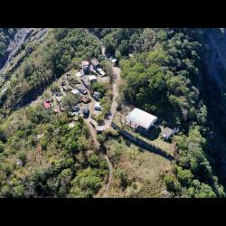
Shenshan Hamlet
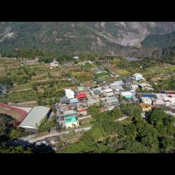
The Shenshan Hamlet is located on the terraced platform on the left bank of Ailiao North River in Wutai Township, Pingtung County, about 700 meters above sea level.
The traditional Rukai name for the village is Kabararayan. Originally, both Shenshan Hamlet and the neighboring Wutai Hamlet originated from old Haocha Village, and they were cultivated almost around the same time. Later, due to the increasing population, some households of the Shenshan Hamlet moved away and formed the Dewen Hamlet and Jiamu Hamlet respectively. In the post-war period, the National Government combined Shenshan Alley and Zhongshan Alley and formed the Huarong Community, which was later renamed as Shenshan Community by the resolution of the villagers’ representatives in 1982.
Today, the Shenshan Hamlet is divided into two parts, namely the older Swabaliu above the main road and newer Laliulu (aka Swalingolo) below the main road.
Qulu (Kinuran) Hamlet
Qulu Hamlet in Wutai Township, Pingtung County, is located below Provincial Highway 24. The terrain generally descends from south to north. During the Japanese occupation, Qulu Hamlet only had 38 households with 197 people. It was a relatively small tribe. The traditional Rukai name for the hamlet is Kinuran. After the war, the National Government renamed the hamlet and transliterated it as Qunu (“Nu” means anger). Due to the sloping terrain of the tribe and the inconvenience in transportation, some people moved to Sanhe Village in Majia Township. During an inspection in 1967, the chairman of Taiwan Province, Huang Jie, found the name indecent, and instructed to change it to Qulu. “Lu” means morning dew, that nourishes the earth. Sadly, Qulu Hamlet was hit by Typhoon Morakot in 2009 and is now relocated to Baihe permanent housing site in Changzhi.
Nanban Shigesuke Monument
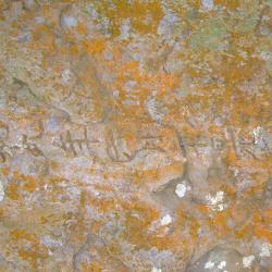
The Nanban Shigesuke Monument is located at the back of Old Haocha Elementary School, on a path that leads to the village’s water source. The monument is made of two large stones stacked together and is 2 meters tall. The words, “Nanban Shigesuke Monument”, are engraved on one side, while the date of death, June 20 Showa 9, is engraved on the other. This monument mainly commemorates Nanban Shigesuke, who served as the head of the Kochayabokan Police Post during the Japanese occupation and ended his life on June 20, 1934.
However, in the post-war period, the National Government filled the monument with cement, painted in white and wrote in blue “Do not forget national humiliation in time of peace and security”. As time went by, the cement that had been smeared gradually eroded and the inscriptions from the Japanese occupation gradually re-emerges.
Suspension Bridge next to Old Haocha Water Source
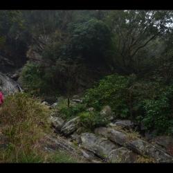
The remains of the suspension bridge next to the water source of the old Haocha Village is about 1,000 meters above sea level. Although the bridge has been destroyed, you can still see the main iron cable of the suspension bridge that spans across the stream. Heading down the mountain along Wutai Haocha Historic Trail you will reach Sandimen. To this day, at the trail entrance next to the water source of the abandoned Old Haocha Elementary School, there is still a complete stone-stacked road. However, there is only about 1 km of walkable historic trail remaining, and the rest have collapsed.
Jiuhaocha (Old Haocha) Elementary School
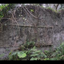
The Old Haocha Elementary School, located in Wutai Township, Pingtung County, is currently abandoned. The ceiling of the building collapsed, leaving only the walls, beams, pillars, and overgrown grass. During the Japanese occupation, the Government-General in Taiwan set up a police post and educational institution on the edge of the Old Haocha Village in the east with the aim to transfer tribal power through the entry of state power, and to become the main authority to manage the village. Also, to stabilize tribal governance through national education and teaching village children Japanese. In the post-war period, the National Government established independent villages based on each police post, and the original educational institute was restructured into the Haocha Public School.
Historic Trail next to Old Haocha Water Source
Wutai Haocha Historic Trail entrance is located next to the water source of the Old Haocha Elementary School and is about 1,000 meters above sea level. Most parts of the trail have collapsed, leaving only about 1 km of the historic trail left for passage. Currently there is a suspension bridge ruin and the stone-stacked road is complete. The original starting point of the Wutai Haocha Historic Trail was located in Zhenxing Village, Yanpu Township, Pingtung County, and passes through Sandimen, Wutai and Old Haocha successively. It has a total length of about 27.9 km. During the Japanese occupation, the trail was designed for connecting villages. Today, the section that starts from Sandimen has been widened and became the Provincial Highway 24 leading to Wutai.
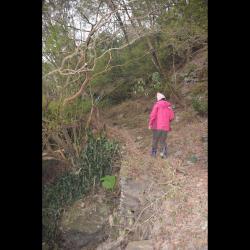
Ladenge Rest Area
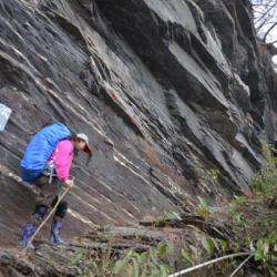
Ladenge Rest Area is located one-third of the trail on the way to old Haocha Village. Along the way, the wrinkled patterns on the rock wall are clearly visible. Once you have passed the rock walls, the path narrows and there are stairs that make the walk easy. Continue on for another 20 minutes and you will arrive at the slate house. Today, entry to old Haocha Village is from the Taiwan Indigenous Peoples Cultural Development Center in Majia Township, Pingtung County. After reaching the end of the Haocha industrial road, walk along Ailiao North River and you will first arrive at the once-flooded new Haocha Village. It then takes about 1.3 km to reach the old entrance for the trail. The altitude difference of the whole journey is about 830 meters, and some sections of the trail are cliffs, which are extremely thrilling.