Atayal

Rixiang Police Post
2003年松安派出所尚未拆除的水泥建築

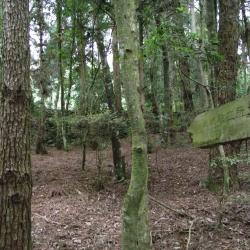
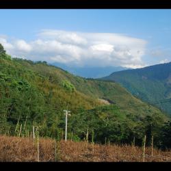
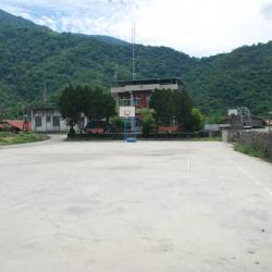
The Rixiang Police Post, in Tai'an Township of Miaoli County, is located at the southeastern foot of Mount Jinwei, east to Xishuishan ridgeline, on the northeastern side of Erbensong, and at an altitude of about 1,410 meters. It was set up in 1923, and was named Rixiang, which means facing the sun, because where the police post stood faces the east. The traditional Atayal name for the place is Ulau-ladin, which refers to the soil being as hard as wood.

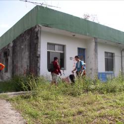
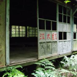
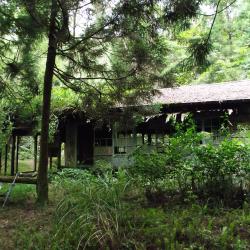
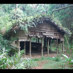
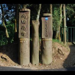
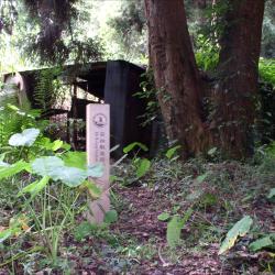
To this day, there is still an abandoned industrial building where the Rixiang Police Post used to stand. The ruins of the station can be found behind the building. The Shei-Pa National Park has set up a signpost of the Police Post.


Song’an Police Station
2003年松安派出所尚未拆除的水泥建築

The Song’an Police Station, in Tai’an Township of Miaoli County, was originally the Erbensong Police Post during the Japanese occupation, built in 1911. In Japanese, Erbensong refers to a place with two pine trees. The traditional Atayal name for the place is Pihun, which means door. Both have the meaning of entering Beikeng Creek.

The Erbensong Police Post was set up with the purpose of monitoring the northern group of the Atayal tribe in the Da’an River Basin during the Japanese rule. However, there have been fierce attacks by the Atayal tribe. In the post-war period, the National Government changed its names to Erbensong Police Station and Song'an Police Station.

When the Jiji earthquake occurred in 1999, police officers were moved to Meiyuan Police Station, which has now been converted into Erbensong Visitor Center.

Sign posting for Beikeng Police Post
北坑溪古道由觀霧入山14.6公里處所設立的北坑駐在所指標

The Beikeng Police Post, in Tai’an Township of Miaoli County, was established in 1923. It is located on the 14.6 km point of the Beikeng Creek Historic Trail and is about 1,640 meters above sea level. The traditional Atayal name for the place is Simayen, which means floor-like lawn.

The Beikeng Police Post was originally the administrative center of the Beikeng Creek Historic Trail. There was an education center, Wude Hall, medical facility, places for trades, guns and ammunition depot and so on, of which the buildings still remain on the trail today.

Around 2003, Xuepa National Park renovated the historic trail section from Guanwu to Erbensong, but due to natural disasters, the entire section was still difficult to pass through and was abandoned. Only a few parts of the trail remain.


Beikeng Police Post
北坑駐在所遺址上的木造工寮,刻畫著到此一遊印記

The Beikeng Police Post, in Tai’an Township of Miaoli County, was established in 1923. It is located on the 14.6 km point of the Beikeng Creek Historic Trail and is about 1,640 meters above sea level. The traditional Atayal name for the place is Simayen, which means floor-like lawn.

The Beikeng Police Post was originally the administrative center of the Beikeng Creek Historic Trail. There was an education center, Wude Hall, medical facility, places for trades, guns and ammunition depot and so on, of which the buildings still remain on the trail today.

To get theret, enter from the Simaxian Forest Road in the Xuejian Recreation Area, climb up the Simaxian Forest Road to an altitude of about 2,000 meters, and then descend about 360 meters to arrive at the station.


Beikeng Police Post (Front)
Tayal,泰雅族,理蕃設施,駐在所

The Beikeng Police Post, in Tai’an Township of Miaoli County, was established in 1923. It is located on the 14.6 km point of the Beikeng Creek Historic Trail and is about 1,640 meters above sea level. The traditional Atayal name for the place is Simayen, which means floor-like lawn.

The Beikeng Police Post was originally the administrative center of the Beikeng Creek Historic Trail. There was an education center, Wude Hall, medical facility, places for trades, guns and ammunition depot and so on, of which the buildings still remain on the trail today.

To get there, enter from the Simaxian Forest Road in the Xuejian Recreation Area, climb up the Simaxian Forest Road to an altitude of about 2,000 meters, and then descend about 360 meters to arrive at the station.


Beikeng Police Post (Side)
北坑駐在所遺址上的木造工寮,為戰後林務局所設置的

The Beikeng Police Post, in Tai’an Township of Miaoli County, was established in 1923. It is located on the 14.6 km point of the Beikeng Creek Historic Trail and is about 1,640 meters above sea level. The traditional Atayal name for the place is Simayen, which means floor-like lawn.

The Beikeng Police Post was originally the administrative center of the Beikeng Creek Historic Trail. There was an education center, Wude Hall, medical facility, places for trades, guns and ammunition depot and so on, of which the buildings still remain on the trail today.

To get there, enter from the Simaxian Forest Road in the Xuejian Recreation Area, climb up the Simaxian Forest Road to an altitude of about 2,000 meters, and then descend about 360 meters to arrive at the station.

Wantian Battery Entrance
丸田砲臺步道的入口處

The Wantian Battery Trail entrance, in Tai’an Township of Miaoli County, is located on the 15 km point of Simaxian Forest Road and is about 1,310 meters above sea level. The trail was set up to monitor the northern Atayal group during the Japanese occupation. The battery was erected on the ridge line or high point of the mountain overlooking tribal villages in order to intimidate indigenous people.

In the early days of Japanese rule, the Governor of Taiwan, Sakuma Samata organized a large-scale crusade to manage the indigenes. In 1911, he suppressed the northern group of Atayal tribe with superior force. Police Officer, Maruda Kiyoshi, was killed during this fight and therefore, the battery was named after him. Today, the remains of the Wantian Battery are hidden in the forest of Cryptomeria.


Overlooking Wantian Battery
從天狗部落遠眺東方稜線上的丸田砲臺

The Wantian Battery in Tai’an Township of Miaoli County is located on the river terrace south-facing from Erbensong Police Post. It is about 1,310 meters above sea level, and was set up to monitor the northern Atayal group during the Japanese occupation. The battery was erected on the ridge line or high point of the mountain overlooking tribal villages in order to frighten indigenous people.

In the early days of Japanese rule, the Governor of Taiwan, Sakuma Samata organized a large-scale crusade to manage the indigenes. In 1911, he suppressed the northern group of Atayal tribe with superior force. Police Officer Maruda Kiyoshi was killed during this fight and therefore, the battery was named after him. Today, the remains of the Wantian Battery are hidden in the forest of Cryptomeria.

Meimu Police Post
力行產業道路上的茶葉工廠即為梅木駐在所舊址

Meimu Police Post, in Ren'ai Township of Nantou County, is located below the Lixing Industrial Road and next to the Meimu Camphor Bureau. It has now been converted into a tea factory.

The Lixing Industrial Road was completed in 1968. The road begins from Wushe in the south and ends in Lishan in the north, connecting to the Central Cross-island Highway. The section from Meimu to Cuiluan was originally part of the Pyanan Historic Trail during the Japanese Occupation period.

Today, the hillsides along the Lixing Industrial Road are rich in non-tropical fruits, but the geology of the area where the road passes is fragile. There are often landslides, hence the road conditions are not good.

The old Ruiyan Police Station
舊瑞岩派出所即為マシトバオン駐在所遺址

The old Ruiyan police station, in Ren’ai Township of Nantou County, is located in the northeastern foothills where Beigang River and Kagao River meet.

The Ruiyan Hamlet was formed by the merger of the Mesiduobang community and the Tieli Lao community. Since Japanese rule, it has experienced multiple group migration policies. In the post-war period, the National Government also changed the name of the hamlet and merged. It was until the Jiji earthquake in 1999 that the Ruiyan Hamlet was relocated again in 2011 due to severe stratum damage. The new location of the hamlet is on the right bank of Beigang River, northwest of the original village. However, there are still 32 households that have not moved due to insufficient land.