Tsou1111

Shitzulu
影像為十字路車站及其前方的鐵道

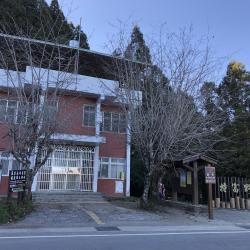
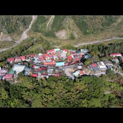
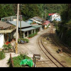
Shitzulu Station was opened in October of the first year of Taisho (1912). It is a stop of the Alishan Forest Railway, with an altitude of about 1,530 meters.  Before the Alishan highway was opened, Shitzulu was the traffic hub in the village, and also the most interacted village and closest to indigenous villages. Since it is located in the midpoint between the Alishan Forest Railway and the Tefuye hamlet of the Cou tribe, the station connects Laiji and Tefuye hamlets. Therefore, the nearby hamlets like Tsatsaya, Shanmei, Lalauya, Laiji, Tefuye had earlier contact with the outside world than other tribes due to their location.

Today, most of the residents of Shitzulu village are descendants of loggers from the Japanese occupation period or employees of the Alishan Forest Railway. In the past, the area was quite developed because there is a train station as well as simple power supply equipment, a post office, and other facilities. However, after the opening of the Alishan Highway, the function of the railway station died away.

Limei Hideout Trail
從山美橋遠眺岳亞那山稜線和達娜伊谷

The Limei hideout trail that is located in Shanmei village and Lijia village in Alishan Township, Chiayi County used to be the main path from Tsou’s Shanmei hamlet to Lijia hamlet.  Starting from Shanmei hamlet, walk along the trail on the left bank of the Zengwen River, enter the Danai Valley, then climb the small branch on the west side of Yueyana Mountain to pass by Yofuni, you will arrive at Lijia hamlet. After the Alishan Highway was opened to traffic, this hideout trail has been abandoned for many years. When the trail was destroyed by Typhoon Morakot in 2009, people of the hamlet began to propose to the Forest Service Bureau to repair this historic trail. Other than for emergency relief, this area was also developed for tourism purposes. The Limei hideout trail was opened in 2013, with a total length of about 2.1 km.


Shanmei Hamlet
2009年莫拉克風災後的山美部落街道一景

Shanmei Hamlet is located in Shanmei village in Alishan Township, Chiayi County. It was originally the location for Shamijishe, a small community of the larger Dabang group. It used to be scattered in the southern base of Mount Sapiji above the present site. However, due to a landslide in the early days of the Japanese occupation, the people moved south to Shamiji and lived close to the police post, where they continued to use the old name. At that time, there were only 2 households with 14 people. In the early post-war period, the number increased to 58 households with 260 people.  When the National Government established an administration hub, the name of the hamlet was directly transliterated into Shanmei village.

Today, Shanmei hamlet has schools, a police station, farmers’ association, offices, churches, etc. It is the center of Alishan Township.

Mount Daitou (Big Tashan)
右側為大塔山主峰,設有觀景臺

Tashan is one of the Alishan mountain ranges. The mountain ranges from east to west. The rock formations are arranged horizontally and stacked on top of each other like a tower. The main peak of Tashan Mountain is 2,663 meters above sea level. It is the holy mountain of the Tsou tribe. The traditional name is Hocubu, which has a meaning of the goblins’ nest and home to the spirits. Tsou people believe that the spirits live on Tashan after death, and that the good spirits live on Big Tashan, while the evil spirits live on small Tashan. Small Tashan is 2,484 meters above sea level, and its traditional name is Maeno, which means peak.

Railway of the Mianyue Line
阿里山林業鐵路的眠月線

The Mianyue Line of the Forest Railway is located inside the Alishan National Forest Recreation Area. It was completed in 1915 and is about 14 km in length from Alishan old station to Songshan station. There are two stations along the way, mainly Tashan and Mianyue. In 1934, the Mianyue Line was dismantled because the logging operation was terminated.  In the early post-war period, due to the need for afforestation along the Alishan Forest Railway, the National Government restored the railway up to the Shihou section. However in recent years, the Mianyue Railway has suffered severe damage from the Jiji earthquake and Typhoon Morakot, and is until today still impossible to pass.


Tfuya Historic Trail
特富野古道約1900公尺處的小鞍部

The Tfuya Historic Trail, which straddles the junction of Alishan Township in Chiayi County and Xinyi Township in Nantou County, mainly leads from Tfuya to Zizhong. It was a path that the Tsou people used for hunting, wedding, and visiting families in the past. In addition, it can be connected to Tataga and all the way to the Yushan area, which is an important passage for connecting Alishan and Yushan. In the middle of the Japanese occupation period, the Government-General in Taiwan rebuilt the old trail adjacent to Zizhong into an old railway on the Shuishan Line, which was used to transport timber. The railway was abandoned in 1977 and in 2001, the 6.32 km long trail that goes from Tfuya to Zizhong was refurbished, preserving the original railway pavement, which is the Tfuya Historic Trail known today.

Looking out to Tashan
從阿里山的沼平向北觀望塔山

Tashan is one of the Alishan mountain ranges. The mountain ranges from east to west. The rock formations are arranged horizontally and stacked on top of each other like a tower. The main peak of Tashan Mountain is 2,663 meters above sea level. It is the holy mountain of the Tsou tribe.

The traditional Tsou name is Hocubu, which has a meaning of the goblins’ nest and home to the spirits. Tsou people believe that the spirits live on Tashan after death, and that the good spirits live on Big Tashan, while the evil spirits live on small Tashan. Small Tashan is 2,484 meters above sea level, and its traditional name is Maeno, which means peak.

Zizhong
自忠路旁可見特富野古道的登山口

Located at the junction of Alishan Township in Chiayi County and Xinyi Township in Nantou County, Zizhong is at the valley pass between the Alishan Mountain Range and the Yushan Mountain Range. During the Japanese occupation, this place was called Eryu (Kodama), mainly in memory of Taiwan Governor Kodama Gentaro. But after the war, the name was changed to Zizhong in memory of Zhang Zizhong, an anti-Japanese General during World War II.  In 1931, the Government-General in Taiwan completed the construction of the Shuishan Line of the Alishan Forest Railway, which went from Zhaoping to Eryu (Zizhong), also known as the Eryu (Kodama) Line.

Tfuya Historic Trail (Old railway of the Shanshui Line)
(阿里山)南北縱貫古道封面照

Located in Alishan Township of Chiayi County, the Tfuya Historic Trail (Old Railway of the Shuishan Line) is a branch line of the Dongpu Line of the Alishan Forest Railway in the past. The railway was completed in 1931, leading from Zhaoping to Eryu (Zizhong), and thereafter extending to Xingaokou. It is a railway built by the Government-General in Taiwan to develop the forest resources of Alishan during the Japanese occupation. Where the old Shuishan line meets Zizhong, there was a railway line branching out to the southwest. That is the current section of the Tfuya Historic Trail. However, the railway was abandoned in 1977. In 2001, the Chiayi Forestry Administration reorganized a part of the railway and made it the Tfuya Trail for tourists recreational hike.

Tfuya Hamlet
從空中俯瞰特富野部落,右下道路可通往特富野古道

Tefuya Hamlet in Dabang Village, Alishan Township in Chiayi County. It is located on the high river terrace on the left bank of the Zengwen River. It is about 1,050 meters above sea level. It is an important passage for the Tsou people to go to Yushan area for hunting. As Tfuye hamlet is situated closer to the source of the Zengwen River, the traditional name is Tsumuna, which means water source. However, relevant documents from the Qing period noted that this place was called Zhumulaoshe or Duwuliaoshe. It was also recorded as Zhimulaoshe or Tunmushe in the early days of Japanese occupation. Both terms were transliterated from the pronunciation of tu-bu-la in Hoklo language. It was not until after the war that the term was transliterated  into Tfuya in Chinese.