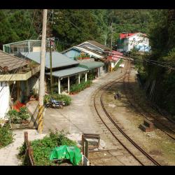
Shitzulu Station was opened in October of the first year of Taisho (1912). It is a stop of the Alishan Forest Railway, with an altitude of about 1,530 meters. Before the Alishan highway was opened, Shitzulu was the traffic hub in the village, and also the most interacted village and closest to indigenous villages. Since it is located in the midpoint between the Alishan Forest Railway and the Tefuye hamlet of the Cou tribe, the station connects Laiji and Tefuye hamlets. Therefore, the nearby hamlets like Tsatsaya, Shanmei, Lalauya, Laiji, Tefuye had earlier contact with the outside world than other tribes due to their location.
Today, most of the residents of Shitzulu village are descendants of loggers from the Japanese occupation period or employees of the Alishan Forest Railway. In the past, the area was quite developed because there is a train station as well as simple power supply equipment, a post office, and other facilities. However, after the opening of the Alishan Highway, the function of the railway station died away.
- - / -
- - - -
- -
- -/-
- -

