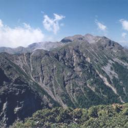
Xueshan is located at the junction of Heping District, Taichung City and Tai'an Township, Miaoli County. It is 3,886 meters above sea level and is the second highest peak in Taiwan. In July of the 4th year of Taisho (1915), Saitsu Kyuhei, the survey team of the Fan Affairs Bureau, and his party, crossed the southern saddle of Pyanan(now Siyuan Yakou) from the southern part of Beiyanshe (now Nanshan Village) to Zhijiayangshe (now Huanshan hamlet), followed by Zhijiayang Dashan ridgeline to complete the first ascent and measurement of the main peak of the snow-capped mountain. Since then, this route has become the most convenient way to climb the sub-alpine mountain (the name of Xueshan during the Japanese occupation). In the 4th year of the Showa era (1929), the governor of Taichung prefecture built the "Chigao Lodge" in the southeastern part of Xueshan, which was the only lodge in the area that accommodates hundred people. After the opening of the Xueshan Mountain Route in 1970, it replaced the Zhijiayang Line as the main route for climbing Xueshan because it was relatively gentle and easy to walk.
Xueshan
Maricowan Police Post
The Marikowan Police Post is located inside the Marikowan Hamlet in Ren’ai Township of Nantou County.
During the Qing period, there were originally four communities: Mklihan, Mkbubul, Mktata, and Mkbabo. However, during the early days of the Japanese occupation, the Government-General in Taiwan sent personnel to the hamlet and demanded the people to hand over firearms. The tribesmen stubbornly resisted, and so police forces were sent to suppress the people as well as burning down the Mklihan community.
In the post-war period, the National Government merged the four tribes into one Cuiluan community (Qalang Bubun). After the completion of the industrial road, some people moved to the roadside to form the Marikowan Hamlet.