Indigene Management Route

Kotohira Shrine
金刀比羅神社的社號碑

The Kotohira Shrine, located in Su’ao Township in Yilan County, was built in 1927 by Shinto shrines carpenters, who arrived in Taiwan during the Japanese occupation. The shrine was for worshiping General Kimpira, one of the 12 Buddhist saints, who is the guardian of sea traffic. Therefore, shrines like Kotohira Shrine are mostly built by ports. 


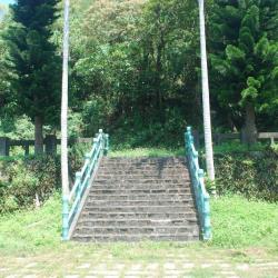
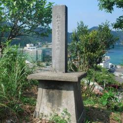
Today, the main building of the Kotohira Shrine no longer exists. Although the foundation and path of the shrine can still be seen with stone benches, stone tables, stone lamps, and stone pillars, and that the overall spatial pattern is still roughly complete, the stone steps below the first level foundation were demolished during the construction of the Suhua Highway. In 2010, the Yilan County Government announced it as the county’s heritage site.


Nan’ao Shrine
南澳祠遺址

Nan'ao Shrine, located in Nan'ao Township in Yilan County, was founded in 1936. The Atayal people call the place “Kinan”, meaning a very beautiful environment.  The name, Nan’ao, first appeared in historical documents in 1810. It was called Da Nan’ao because it was located in the south of Su’ao. It was only renamed to Nan’ao during the Japanese pccupation period. After the establishment of the Nan’ao community in 1932, this name got widely accepted by everyone.

Da Nan’ao
過去的南澳鄉戶政事務所門柱,現已成為餐廳招牌基座

Da Nan’ao is located on the plateau on the left bank of Northern Da Nan’ao River in Nan’ao Township of Yilan County. It is surrounded by mountains and faces the ocean on the east. The Atayal people call the place “Kinan”, meaning a very beautiful environment.  The name, Nan’ao, first appeared in historical documents in 1810. It was called Da Nan’ao because it was located in the south of Su’ao. It was only renamed Nan’ao during the Japanese occupation period. After the establishment of the Nan’ao community in 1932, this name got widely accepted by many.

Today, Nan'ao Village is adjacent to Chaoyang and Nanqiang Erli in Su'ao Township.

Da Nan’ao Traversing Trail
蘇花古道大南澳越嶺段的入口指示

Da Nan’ao Traversing Trail of Nan’ao Township, Yilan County, is located between Su’ao and Hualien Port. It was built by the Government-General in Taiwan during the Japanese occupation in 1916. Due to the needs of developing the eastern area and that the location was closest to the Governor Office, the 12-foot-wide historic walking trail was widened and made into roads for car traffic. The road passes through many indigenous villages and was named Linhai Historic Trail.

Up until today, the Suhua Linhai Historic Trail has undergone many road-widening and adjustments, with old cliff roads replaced by tunnels to prevent danger caused by falling rocks.

Luo Dachun Road Excavation Monument
羅大春開路紀念碑安座於震安宮旁的碑亭內

The Luo Dachun Road Excavation Monument is located inside the pavilion next to Zhennan Temple on Chaoyang Road in Su’ao Township of Yilan County. It is respected by locals as Shipaizigong. Every year on July 29 of the lunar calendar many people come to pay respect here. In fact, the Luo Dachun Road Excavation Monument was originally set up on an historic trail about 300 meters southeast from the current site, facing Hualien. However, due to the excavation of Nan’ao area, the current Chaoyang Road has become an important passage to and from Nan’ao. Gradually, the historic trail got abandoned and got made into a water diversion channel. The remains of the barren tomb beside the historic trail were discovered during the reclamation, and the locals enshrine it with the excavation monument for people to remember.

Gukut Police Post
グークツ駐在所仍保有完整的木構建築,現為民宅

Located in Xiulin Township, Hualien County, the Gukut Police Post is located 300 meters south of the Hezhong Hamlet. It is now a residential house, but still retains a complete wooden structure from the Japanese occupation period. In the past, the Truku people expanded north and established hamlets on the hillside, with the Pacific Ocean in the east and the central mountain range in the west. As the terrain and space resemble a circular pan-bottom, the place was named Gukut, and was the earliest settlement of the Truku people. However, during the Japanese occupation, several hamlets were collectively moved to the present location, and continued with the name “Gukut”.

In the post-war period, Gukut Hamlet was renamed to Heping, and later called Hezhong because it was located in the middle of three communities of Heping Village.

Qingshui Cliff
從臨海崩石坡遠眺清水斷崖和清水隧道

The Qingshui Cliff in Xiulin Township, Hualien County is located on the way between Su’ao and Hualien Port. It was excavated by the Government-General in Taiwan during the Japanese occupation in 1916. Due to the needs of developing the eastern area and that the location was closest to the Governor Office, the 12-foot-wide historic walking trail was widened to make into roads for car traffic. The road passes through many indigenous villages and was named Linhai Historic Trail. Up until today, the Suhua Linhai Historic Trail has undergone many road-widening and adjustments, with old cliff roads replaced by tunnels to prevent danger caused by falling rocks.

Suhua Historic Trail
從石硿子段的蘇花古道遠眺清水斷崖

The Suhua Historic Trail, which runs through Su’ao Township in Yilan County and Hualien City in Hualien County, was first excavated in 1874 (Qing period). The trail starts from Su’ao in the north and ends in Hualien Port in the south, with a total length of about 115 km. During the Japanese occupation in 1916, the Government-General in Taiwan began re-building the road between Su’ao and Hualien Port, which went all the way from Baimi Bridge in Su’ao to Zhuzi Bridge in Hualien Port Street. Later, the 12-foot-wide trail was converted into a road for car traffic that passes through many indigenous villages.

Today, the Yilan section of the Suhua Historic Trail that was excavated during the Qing Dynasty remained the same, while the Suhua Linhai Historic Trail along the coast that was built during the Japanese occupation has undergone many road-widening and adjustments. The old cliff road was even replaced with tunnels to prevent danger caused by falling rocks.

Hualien County Police Station, Xincheng Branch
原為研海支廳廳舍的新城分局

The police station in Xincheng Township, Hualien County was originally the Yanhai branch office that was established by the Government-General in Taiwan during the Japanese occupation.  Today, the fence of the building still remains. After the Taroko War in 1914, Sakuma Samata, the Governor at that time, was deeply admired in Hualien. In commemoration of his achievements, the Government-General in Taiwan merged the Xincheng Branch and the Taroko Branch in 1920 and named it Yanhai after Sakuma.

Later in 1937, there was a restructure of the Hualien area; and the branch offices became counties, while districts were changed to townships. Since then, the Yanhai Branch in Hualien County governed the current Xincheng Township and Xiulin Township. After the war, the National Government restored Yanhai to its old name “Xincheng”.

Shu’anbu
曙鞍部即為北坑山和鹿場大山稜線的最低鞍

Shu’anbu is located at the lowest saddle on the ridge line of Mount Beikeng and Luchang Dashan, about 2,000 meters above sea level. It is a small flat land but was the transportation hub between Shangdao Hot Spring, Luchang Dashan, Luchang, Shu, Beikeng and other transportation hubs during the Japanese occupation. In the past, there used to be huts for people to rest.

Today, Shu’anbu is covered in overgrown miscanthus, making it difficult to look out at the scenery. Also, no items left from the Japanese occupation period have been found. The section of the historic trail leading to Sishui Police Post has been seldom used and the road conditions are not suitable for hiking.