The stone lion base in front of the Tianjun Temple was originally the x base for the stone lanterns of Kotohira Shrine. The pair of stone lanterns from the Kotohira Shrine was moved to both sides of the entrance of the Tianjun Temple. Therefore, the remaining base was painted yellow and a small stone lion was placed on it. The age and the name of the donor can still be seen on the base. The left and right bases have the engraving of "Showa 6th Year" (1931) and "Showa 4th Year" (1929) respectively, which clearly prove that they belong to the Kotohira Shrine.
Linhai Road
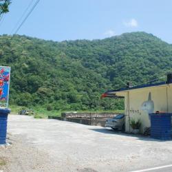
Heren Hamlet
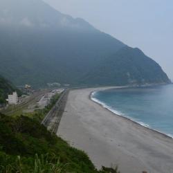
The image shows Heren hamlet in the distance, a view from the Suhua Highway. The hamlet belongs to the Truku tribe and is located on the left bank terrace of the Liangli River estuary. It sits 45 meters above sea level, faces the Pacific Ocean in the east, mountains in the west, Liangli River and Chongde village in the south, and is 4 kilometers adjacent to the Hezhong community in the north. The original hamlet, Btakan-she, was established on the mountainside opposite the current location and was only moved to the current location after the Japanese occupation. Truku people named the hamlet “Qnragan", which later on becomes "Qnagan". It means bare trees because when the tribesmen first arrived here, it was so windy that trees were blown down, and leaves were falling that making them bare. During the Japanese rule, some tribes such as Skadang, Squrxan, Bmux, Quwis, Lapax moved into the hamlet. At the end of the Japanese rule, the people relocated to what is today’s Zhihezhong community. After the war, they moved back but west of the current location and named it Heren. In 1948 the hamlet got washed away by a typhoon and so the people moved to the present site.
South End of Chongde Tunnel
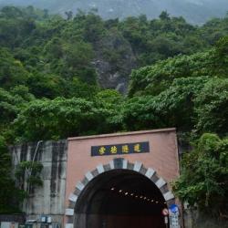
The Chongde Tunnel was opened to traffic on August 10, 1990, with a total length of about 325 meters. The Shigangzai section of Suhua Historic Trail still remains above the tunnel and can be reached from the south end of Chongde Tunnel. In 2012, it was attacked by moderate typhoon Sula, and the area for car parking at the south end of the tunnel was washed away due to heavy rain.
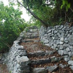
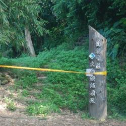
The Shigangzai section of the Suhua Historic Trai belongs to the Taroko National Park and is temporarily closed, and due to the rapid climate change in recent years, the Taroko National Park Headquarters has no restoration plan. This trail is one of the coastal Lifan roads excavated in the 3rd year of Taisho (1914). Today, there are still complete stone steps along the way, where you can overlook the Qingshui cliff.
Suhua Historic Trail (Shigangzi section)II
The investigation by Yang Nanjun, an ancient trail researcher, confirmed that the preservation of the North Suhua Historic Trail was not as good as the other two trails. The main reason is that most of the uphill and downhill sections use timber steps, which are more prone to decay. Also, with the defense and attack of indigenous people, officials and others tend to take the safer sea route.
After his investigation, the Shigangzi trail between the south entrance of the Chongde Tunnel and Shigangzi is the most complete. Yang pointed out that the average width of the Shigangzai trail is 120 cm, and there are lower ridges at the cliffs. One of the broken rock zones is paved with stones to form a flat road with a width of 180 cm. It is one of the important landscape assets of Taroko National Park to provide a view of Qingshui Cliff directly into the Pacific Ocean.
Ciwang Presbyterian Church
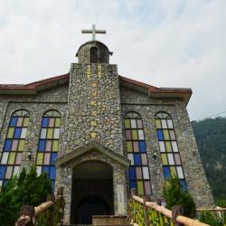
Ciwang.Iwal (1872-1946) was the first Truku Christian to be baptized. When Ciwan was in trouble, she met Li Shuiche of the Hualien Port Church who preached the gospel to her. In June of the 13th year of Taisho (1924), she was baptized by Pastor Liu Junchen of the Hualien Port Church and became the first Christian of the Truku tribe. In the 4th year of the Showa era (1929), when Pastor Sun Yage, a missionary, went to the east, he personally brought Ciwang to Tamsui Women's Bible College for theological training. After graduation, she returned home to preach the gospel to her people. After Ciwang passed away, a proposal was put forward in 1958 to set up a Memorial Church in Fushi Village. The proposal got approved, and fundraising began. With the sponsorship of various churches and foreign believers, the construction was completed in the summer of 1961. The inauguration ceremony was held on November 29 of the same year. It was named Ciwang Memorial Church.
Paotaishan (Fort Mountain)
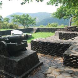
Paotaishan (Fort Mountain) is located on the 105 km way of Provincial Highway 9 in the south in Su’ao Township, Yilan County, at an altitude of about 200 meters. It was built in 1884 when the Qing-French War broke out. The French army attacked Su’ao; and the Blue Cap commander Chen Hui-huang took advantage of the superior terrain of Paotaishan and carried cannons up the mountain with the help from local residents. The fortress and barracks were built there in consideration of the military fortress, and hence, the name “Paotaishan” (Fort Mountain) came about.
To this day, the six hundred-strand front chamber cast iron guns are stored in the warehouse of the Su’ao Township Office.
Kotohira Shrine
The Kotohira Shrine, located in Su’ao Township in Yilan County, was built in 1927 by Shinto shrines carpenters, who arrived in Taiwan during the Japanese occupation. The shrine was for worshiping General Kimpira, one of the 12 Buddhist saints, who is the guardian of sea traffic. Therefore, shrines like Kotohira Shrine are mostly built by ports.
Today, the main building of the Kotohira Shrine no longer exists. Although the foundation and path of the shrine can still be seen with stone benches, stone tables, stone lamps, and stone pillars, and that the overall spatial pattern is still roughly complete, the stone steps below the first level foundation were demolished during the construction of the Suhua Highway. In 2010, the Yilan County Government announced it as the county’s heritage site.
Nan’ao Shrine
Nan'ao Shrine, located in Nan'ao Township in Yilan County, was founded in 1936. The Atayal people call the place “Kinan”, meaning a very beautiful environment. The name, Nan’ao, first appeared in historical documents in 1810. It was called Da Nan’ao because it was located in the south of Su’ao. It was only renamed to Nan’ao during the Japanese pccupation period. After the establishment of the Nan’ao community in 1932, this name got widely accepted by everyone.
Da Nan’ao
Da Nan’ao is located on the plateau on the left bank of Northern Da Nan’ao River in Nan’ao Township of Yilan County. It is surrounded by mountains and faces the ocean on the east. The Atayal people call the place “Kinan”, meaning a very beautiful environment. The name, Nan’ao, first appeared in historical documents in 1810. It was called Da Nan’ao because it was located in the south of Su’ao. It was only renamed Nan’ao during the Japanese occupation period. After the establishment of the Nan’ao community in 1932, this name got widely accepted by many.
Today, Nan'ao Village is adjacent to Chaoyang and Nanqiang Erli in Su'ao Township.
Da Nan’ao Traversing Trail
Da Nan’ao Traversing Trail of Nan’ao Township, Yilan County, is located between Su’ao and Hualien Port. It was built by the Government-General in Taiwan during the Japanese occupation in 1916. Due to the needs of developing the eastern area and that the location was closest to the Governor Office, the 12-foot-wide historic walking trail was widened and made into roads for car traffic. The road passes through many indigenous villages and was named Linhai Historic Trail.
Up until today, the Suhua Linhai Historic Trail has undergone many road-widening and adjustments, with old cliff roads replaced by tunnels to prevent danger caused by falling rocks.