
The residents of this hamlet were originally residents of old Dagu (Tjarilik) and neighboring Gutanas and Enivaian hamlets. They moved here in 1953 due to the inconvenience of living in a steep mountainous area. The tribesmen of old Dagu hamlet chose to live on the land where Morinaga Hoshinaen Co. Ltd. specialized in planting quinine, coffee, and tea during the Japanese occupation. Later, this hamlet was named Senyong (Morinaga) after the farm. Tjarilik, the name of the old tribe of the Paiwan people, means steep mountains, while Gutanas means the tribe on the cliff, and Enivaianmeans a place with big and sacred trees.
South Qing Period Road
Senyong Presbyterian Church
Shimen Historic Battlefield
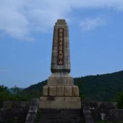
The Shimen Historic Battlefield is located at the junction of Checheng Township and Mudan Township in Pingtung County, in the hilly and mountainous areas of the Sichong River and its tributaries. Since the Mudan incident, the Japanese have been calling the place Shimen. In the post-war period, the village and township was named after it.
As a fact, the former Monument of Commander Saigo Judo and the Monument of the Loyal Soul (in memory of the Japanese soldiers who were killed in the battle between indigenous peoples) were built to commemorate the Mudan Incident. In the post-war period, the monuments were deemed a humiliation to the country, and thus the words on the monument were replaced to commend the anti-Japanese spirit of the indigenous peoples.
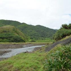
Nureng River
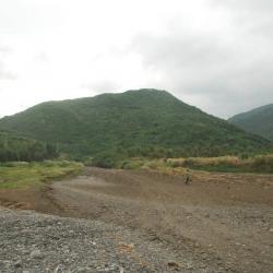
Nureng River that flows through to the Xuhai end of the Hengchun Beinan Historic Trail is located in Mudan Township in Pingtung County. As rainfall happens in summer, the river turns into a low current in winter and becomes a barren stream. The Hengchun Beinan Historic Trail, which crosses Hengchun Township in Pingtung County and Taitung City in Taitung County, runs northward along the coast from Hengchun through Manzhou, joining other trails in Pingtung, and then arriving at Taitung City. In the middle of the Japanese occupation period, the Hengchun Beinan Historic Trail had long been widened as a designated road for cars. Therefore, the remainder of the trail that we see today are mostly roads for cars during the Japanese occupation. Currently the impassable section of the road is in the Guanyinbi area.
Bayao Bay
Bayao Bay is located on the east coast of the Hengchun Peninsula in Manzhou Township, Pingtung County. It is a historical site for the Mudan incident that happened during the Qing period. At that time, the ship Yamahara voyaged from Miyako Island of Ryukyu to Naha to pay the annual tribute. On its return it got blown off course, hit by a typhoon and shipwrecked off the southeastern coast near Bayao Bay. After the sailors on board landed, they were killed by the Paiwan people of the neighboring Gaoshifuoshe. Ryukyu Kingdom was at that time in the sphere of Japanese influence and therefore, Japan used this incident as an excuse to attack Taiwan and the indigenous people in 1874, and eventually annex Ryukyu Kingdom in 1879. This Mudan incident was a wake-up call for the Qing government and they began to actively manage the Hengchun Peninsula, and the Taiwanese policy also changed drastically.
Manzhou Gangzai Village
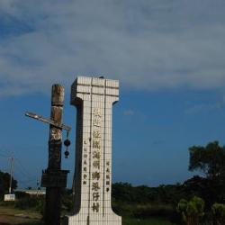
Gangzai Village is located at the northernmost of the Manzhou Township in Pingtung County. It is almost mountainous. The riverbanks of Gangzai River and its tributary Jiaoxi, as well as the river valley plain where the stream flows into the ocean are the main farmland for the whole village. In the past, Gangzai Village was the traditional territory of the Gaoshifuoshe of Paiwan ethnic group. Later, Amis people from the Hengchun area also settled here. The village used to be a passing point on the Langjiao Beinan Historic Trail, but today it has been rebuilt as the end of County Road 200, which is remote and inconvenient for transportation.
Street of Manzhou
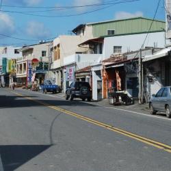
Manzhou Village is located in the basin of Gangkou River and its tributary Laofo River in Manzhou Township, Pingtung County. In the past, it was the traditional hunting ground for the Wenshuai-Shandingshe of Paiwan ethnic group and the Zhusheng-sushe (Ciljasuak) of Seqalu ethnic group. Later, the Hakka immigrants came here to cultivate. During the Japanese occupation period, Taiwan’s Government-General set up villages, public schools, police posts, telecommunication offices, post offices, and other facilities here, making it the administrative center of Manzhou Township. In 1920, local system corrections were implemented and Wenshuai was re-named to Manzhou. However, as the two characters of “Manzhou” is the same as the Manzhou in north-eastern China, it got opposed by residents and was rewritten to the current name.
Chuhuo
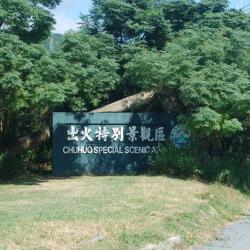
Chuhuo is located outside Hengchun East Gate in Hengchun Township, Pingtung County, and under the Erchongxi Bridge on the 3 km point on the northern side of County Road 200. It is a famous geological landscape in Hengchun Peninsula. The burst of fire on the ground surface is formed by the natural gas stored in the mudstone layer. However, since the location of the fire shifts, the locations of Chuhuo settlement and the Shanhuo bridge are not on the current scenic spots. In fact, the Chuhuo settlement was near Chuhuo Bridge because in the early days of the Japanese occupation, it was probably located on the Chuhuo Riverbank.
Nowadays, people live on the north side of the highway. Although there are not many households there, based on the sacrificial pot that was left there, the place was once inhabited by the Pingpu ethnic group, and was called Pingpufan Cuozhuang.
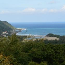
Xuhai end of Hengchun Beinan Historic Trail
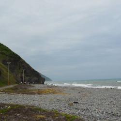
The Hengchun Beinan Historic Trail, which crosses Hengchun Township in Pingtung County and Taitung City in Taitung County, runs from Hengchun via Manzhou, passing through the end of the Central Mountain Range to reach the coast, and then passing through Xuhai and Guanyinbi. Continue walking north along the coast, you will pass by Nantian Hamlet and Anshuo Hamlet, joining other trails that leads to Pingtung, and finally arriving at Taitung City. In the middle of the Japanese occupation, the Hengchun Beinan Historic Trail had long been widened as a designated road for cars. Therefore, the remaining trails that we see today are mostly roads for cars during the Japanese occupation period. Currently the impassable section of the road is in the Guanyinbi area.
Guanyingbi
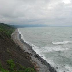
Guanyinbi is located in Mudan Township, Pingtung County, and is on the Hengchun Beinan Historic Trail. The historic trail, which crosses Hengchun Township in Pingtung County and Taitung City in Taitung County, runs from Hengchun via Manzhou, passing through the end of the Central Mountain Range to reach the coast, and then passing through Xuhai and Guanyinbi. Continue walking north along the coast, you will pass by Nantian Hamlet and Anshuo Hamlet, joining other trails that leads to Pingtung, and finally arriving at Taitung City. In the middle of the Japanese occupation, the Hengchun Beinan Historic Trail had long been widened as a designated road for cars. Therefore, the remaining trails that we see today are mostly roads for cars during the Japanese occupation period. Currently the impassable section of the road is in the Guanyinbi area.
Tawa River
The Tawa River Basin in Daren Township, Taitung County, originated from the valley between Mudanxi Mountain and Taihe Mountain, and finally flows into the Pacific Ocean. The Hengchun Beinan Historic Trail, which crosses Hengchun Township in Pingtung County and Taitung City in Taitung County, runs northward along the coast from Hengchun through Manzhou, joining other trails in Pingtung, and then arriving at Taitung City. In the middle of the Japanese occupation, the Hengchun Beinan Historic Trail had long been widened as a designated road for cars. Therefore, the remaining trails that we see today are mostly roads for cars during the Japanese occupation period. Currently the impassable section of the road is in the Guanyinbi area.