Sediq

Tianchang Tunnel
位在奇萊保線路上的天長隧道西端入口

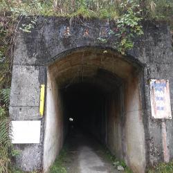
The Tianchang Tunnel, located between Qilai Villa and Panshi Tai-Power Hut, has a total length of 1,270 meters and is slightly S-shaped. In the post-war period, the Nationalist Government erected iron towers along the Nenggao Traversing Historic Trail as a protection route for power transmission from east to west, and turned the police posts that were left from the Japanese occupation into maintenance huts. At the end of the 1970s, efforts were made to plan the Qilai water diversion project. They excavated a road from Tongmen to Qilai for traffic and built a long tunnel. Although this has reduced the inconvenience caused by trekking, the historic trail was destroyed as a result.

Today, the middle section of the tunnel has collapsed and vehicles can no longer pass through.


Stele of Shibata Ichi
位於天長斷崖下方的柴田一之碑

The Shibata Ichi Stele is located under the Tianchang Cliff, between the west entrance of the Tianchang Tunnel and the Lower Qilai Bridge. It is about 1,168 meters above sea level. The stele was erected in memory of Shibata Ichi, who accidentally fell off Tianchang cliff on his way to assist in the Wushe incident. He was in office at the Hualien Port Police Department and so the Governor-General in Taiwan set up a monument under the Tianchang cliff to commemorate his death. In addition, the nearby creek and suspension bridge crossing the creek was named after Shibata. However, in the post-war period, Shibata Creek Suspension Bridge was renamed Lower Qilai Bridge, and Shibata Creek was renamed Tianchang Creek.

Guilin Tai-Power Hut
檜林保線所的主建築為一棟日式房舍

The Nenggao Traversing Historic Trail was built in the middle of the Japanese Occupation period. In the post-war period, the Nationalist Government erected iron towers along the trail for power transmission from east to west to facilitate economic development. In order to maintain the transmission lines, Tai-Power has set up nine maintenance huts along the way to provide accommodation for the maintenance personnel of the transmission lines, and also to store emergency repair equipment. These nine huts were converted from the police posts that were left from the Japanese occupation period, except for one, which is the East Nenggao Police post because it sits on a mountain slope. The Nenggao Traversing Historic Trail has since become the main road for patrolling the towers. Guilin Tai-Power Hut got its name from the cypress forests (Guilin) nearby. 


Monument of Spread Light Across the Land
從空中俯瞰光被八表紀念碑

The Monument of Spread Light Across the Land sits on the saddle of Mount Nenggao, between the northern peak of Nenggao and Mount Kahor. It is about 2,800 meters above sea level and was built in August 1953. It mainly commemorates the construction of the east-west power lines.

The monument is titled with Guang-Bei-Ba-Biao (Spread Light Across the Land) and has inscriptions that records the hardships of this project. There were originally three monuments in the same area that were erected during the Japanese occupation, respectively commending Awui Watan, the Sediq mail deliveryman who died on duty in 1918, Junsaku Nakano who died in the snow in 1921 for escorting mail on his way home, and Eitaro Maruta who fell into the cliff due to repairing a telephone pole in 1930. Unfortunately these monuments were all destroyed, and only the pedestal remains.


Overlooking Shoucheng Dashan
從天池山莊到能高鞍部的路上,遠眺守城大山

Shoucheng Dashan is located at the junction of Puli Township and Renai Township in Nantou County. It is about 2,420 meters above sea level and nestled above the Wushe area. As it is located in the northeast of the Puli basin, it guards Dapu city (now Puli), therefore, it is called the Shoucheng Dashan (City Guard Mountain). It was also once called Huagai Mountain as recorded in the Changhua County Records.


Overlooking Mount Shenku
從能高鞍部遠眺天池山莊上方的深堀山

Mount Shenku, located in Renai Township, Nantou County, was named after a captain who was sent by the Governor-General in Taiwan to investigate Nenggao terrain, forest, the distribution of indigenous tribes in the mountains and to look into the excavation of roads in 1897. Unfortunately, the captain and his entire crew have lost contact while encountering heavy snow on the main ridge of the Central Mountain Range. Search team was sent by the Puli Reclamation Department to search and rescue, but only to find relics of their belongings. This was the first incident in which all members of the expedition were annihilated during the Japanese occupation. Mount Shenku was named in memory of the death of the crew.

Tianchi Pond
乾涸的天池為一片沙地,被箭竹叢包圍

Tianchi Pond is located on the rear edge of Tianchi Lodge and sits on the lowest saddle between Mount Qilaili and Mount Nanhua. It is about 3,080 meters above sea level.

To get there, you can walk up from the fork above the lodge, through a forest of arrow bamboo and arrive at Tianchi. The journey takes about 30 minutes. The water source of the Tianchi Pond comes entirely from the rain, which is filtered and collected by dense grassland. When the water level is full in the rainy season, the pond can reach a hundred meters in diameter. However, in the dry season it may be completely dried up, exposing the sand at the bottom of the pond. In addition, the old route of Nenggao Traversing Historic Trail that was built in 1918 stretched from Tianchi Lodge to Tianchi Pond, and then to the mountainside road of Mount Qilaili.


Nenggao Falls
在能高吊橋上遠眺能高瀑布

Nenggao Falls, located in the upper Tarowan Stream, is about 2,800 meters above sea level. It is one of the famous high-altitude waterfalls in Taiwan with a height difference of 200 meters. As the water flows down in three stages, it is also called three-tiered falls.

In addition, the waterfall is divided into two streams from the middle section and looks like a couple standing side by side. Hence, during the Japanese occupation, it was called Husband and Wife Falls. If you want to get closer to the Nenggao Falls, you can go down to the valley from the small trail next to the Nenggao Suspension Bridge that is between Songyuan Police Post and Tianchi Lodge. The deep pool below the waterfall shows the towering mountain wall and the majestic waterfall.

Overlooking Tianchi Lodge
從能高越嶺古道12.2公里處遠眺天池山莊

The Nenggao Traversing Historic Trail has always been the road used by the Sediq people to hunt and travel.

In the Taroko War in 1914, this road was also used by the Governor-General in Taiwan to send troops to attack the Turuku people. Later, in order to seek long-term stability, the Chuying to Qilai crossroad was excavated along the existing old Nenggao Trail. However, due to the high elevation of the east section of the trail and that it was difficult to pass during winter, the whole trail was rebuilt in the middle of the Japanese occupation period. Many police posts were also built along the way, including Tunyuan station, Fushijian station, Weishan station, Nenggao station, East Nenggao station, and Banbian station. In addition to the deployment of police, it also provided accommodation facilities for hikers.


Songyuan Police Post
松原駐在所蓄水池下方的三層疊石

The Songyuan Police Post, located between the Yunhai Tai-Power Hut and Tianchi Lodge, is 7.8 km away from the Nenggao Traversing Historic Trail and is about 2,600 meters above sea level. It is named Songyuan because there are pine forests around the place. Where the Songyuan Police Post sits occupies a wide area, including stone masonry platforms, walls, stairs, cisterns, and relics. There are steps and ramps at the entrance of the police post that connects to the historic trail. Today, the steps remain complete but are covered in weed shrubs.