Sediq

Old utility pole on Nenggao Traversing Trail
五甲崩山高遶路起點處的一根舊電線杆。

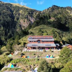
Nenggao Traversing Historic Trail route starts from Tunyuan Mountain Pass in Renai Township, Nantou County. Going east, winding around the mountainside in the south of Weishang Mountain, passing the Yunhai Tai-power Hut and Tianchi Lodge, then cross the Nengao Saddle in the south of the Nengao North Peak in the Central Mountain Range, and then all the way downhill, passing through the Guilin Tai-power hut, Wujiabeng Mountain, and down to the eastern part of Qilai Tai-power hut, and finally arriving at Tongmen Village, Xiulin Township, Hualien County. 


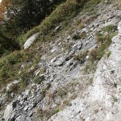
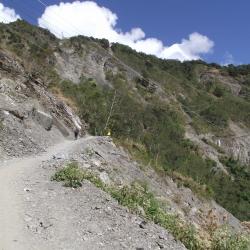
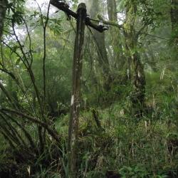
In the late 1970s, due to the erosion caused by the convergence of two rivers, the mountaisides began to collapse vigorously that left no traces of the traversing trail. Hence, the only way in was through Tai-power maintenance road, up to the top of Wujiabeng Mountain, then down to the east entry of the trail at the end of Qilai Tai-power maintenance road.

Collapsed section of eastern part of Neggao Traversing Historic Trail
上檜林吊橋和檜林保線所之間的一處崩塌地,路徑窄小,僅容一人通過,現場已架設繩索確保安全。

In the 6th year of Taisho (1917), the Japanese government opened up the Nenggao Traversing Trail and named it "Hatsune Qilai Crossroad", which is the old Nenggao Traversing Trail. In the 14th year of Taisho (1925), due to the high altitude of the eastern section of the old trail, snow often made it difficult to travel in winter, and the entire Traversging Trail of Hualien Harbor Hall and Nantou Hall was rebuilt, with a total mileage of 76.8 kilometers after completion.

   After the war, in order to restore the power system on the island of Taiwan, the Nationalist Government built a number of towers along the Nenggao Traversing route to complete the "East-West Link Transmission Line". In 1998, after the completion of the new east-west transmission line between Mingtan and Fenglin, the old east-west line was gradually replaced until it was officially decommissioned in 2016. At present, the west section of Nenggao Traversing Trail is well maintained due to the demand for the transportation of materials from Tianchi Lodge, and passing of locomotives. The eastern section, on the other hand, has a low utilization rate after the withdrawal of Taipower personnel, and the road conditions are not as good as the western section.


Upper Guilin Suspension Bridge
上檜林吊橋

The Upper Guilin Suspension Bridge on the eastern section of Nenggao Traversing Trail is located between the Neggao Saddle and the Cypress Forest Preservation Office, with an altitude of 2,740 meters. Since the eastern section of Nenggao Trail is less used, both important suspension bridges on the way, the Upper Guilin Suspension Bridge and the Guiqi Suspension Bridge, fell into disrepair and became hazardous. In the 6th year of Taisho (1917), the Japanese government opened up the Nenggao Traversing Trail and named it "Hatsune Qilai Crossroad", which is the old Nenggao Traversing Trail. In the 14th year of Taisho (1925), due to the high altitude of the eastern section of the old trail, snow often made it difficult to travel in winter, and the entire Traversging Trail of Hualien Harbor Hall and Nantou Hall was rebuilt, with a total mileage of 76.8 kilometers after completion.

   After the war, in order to restore the power system on the island of Taiwan, the Nationalist Government built a number of towers along the Nenggao Traversing route to complete the "East-West Link Transmission Line". In 1998, after the completion of the new east-west transmission line between Mingtan and Fenglin, the old east-west line was gradually replaced until it was officially decommissioned in 2016. At present, the west section of Nenggao Traversing Trail is well maintained due to the demand for the transportation of materials from Tianchi Lodge, and passing of locomotives. The eastern section, on the other hand, has a low utilization rate after the withdrawal of Taipower personnel, and the road conditions are not as good as the western section.


Tianchi Lodge
 空拍天池山莊,中間主建築為住宿區和餐廳,右邊獨立小屋為廁所。下方規劃為露營區。天池山莊位於能高北峰西側山坳避風處,海拔2680公尺,是能高越嶺道的最高點。

The Tianchi Lodge is located in the sheltered area of ​​the mountain depression on the west side of Nengao North Peak, with an altitude of 2680 meters, which is the highest point of Nenggao Traversgin Historic Trail. When the trail was completed in September of the 7th year of Taisho (1918), the Nenggao Police Post was established to meet the needs of road maintenance and mail delivery. It was burned down in the Wushe incident in Showa 5 (1930). In Showa 6 (1931), the cypress house was rebuilt on the original site. Its shape is the same as that of Weishang police post (the current Yunhai Tai-power hut). After the Republic of China, Taipower continued to use it as Tianchi Tai-power hut. In 1986 It was burned down and rebuilt in 1993. Due to the increasing number of mountaineering tourists, it far exceeded the capacity of the lodge. Therefore, in 2011, the Forestry Bureau rebuilt a new Tianchi lodge on the original site with the concept of green building design. This luxurious building is quite high, imposing manner of the cypress palace.

West section of Nenggao Traversing Historic Trail
能高越嶺道的一段路,距屯原登山口約10分鐘路程,此處路面寬大平坦,上方為尾上山之稜線。

This section of Nenggao Traversing Trail is about 10 minutes away from the Tunyuan Mountain Trail. The road here is wide and flat, and the top of the road is the ridgeline of Weishang Mountain. The climbing route of Nenggao Mountain starts from the Tunyuan mountain pass in Renai Township, Nantou County, all the way eastward, wraps around the mountainside in the south of Weishang Mountain, then crosses the Nenggao saddle in the south of Nenggao North Peak of the Central Mountain Range, and then goes all the way downhill. After passing Wujiabeng Mountain, down to the east of Taipower Maintenance Road, and finally arriving at Tongmen Village, Xiulin Township, Hualien County. Its subtropical alpine grassland landscape, the majestic mountain scenery of the Central Mountains, the virgin forest with vigorous giant trees, the waterfalls and springs on the cliffs, the cliff canyons, the deep ravines on the mountain tops, and the clear and delicate Qilai Tianchi have four distinct seasons. The beautiful mountain scenery has attracted many mountain-loving mountaineers to visit since the Japanese colonial period.

Liying Police Post
位於立鷹山頂的立鷹駐在所,現為氣象局立鷹中繼站

Liying Police Post is located on the top of Mount Liying, above New Bowang Village of Qingjing Farm in Ren’ai Township, Nantou County. It is 2,219 meters above sea level and overlooks the Xueshan Range, the Hehuan peaks, the Qilai peaks and the Shoucheng Dashan. This place was originally the ruins of the Seediq’s Tadaka Hamlet of the Wushe group. During the Japanese occupation, the Governor-General in Taiwan had a fort to suppress the hamlet of the Wushe group. Today, there are forest trails and industrial roads that lead to the top of the mountain.


Renzhiguan
位於霧埔公路大觀橋和仁愛橋之間的人止關

Renzhiguan, located between Daguan Bridge and Ren'ai Bridge on Provincial Highway 14, was a gate that was set up during the Qing period to prohibit the Han people from entering the area and to prevent the Han immigrants from having conflicts with the Sediq tribe. However, in the early days of the Japanese occupation, the Governor-General in Taiwan launched a series of large-scale battles against the Sediq tribe in the Wushe area. Both sides suffered heavy losses. Later, the Japanese implemented the strategy of ruling indigenous peoples by their own kind and successfully broke through the defense line. In 1908, police officials were stationed in Wushe, and they devoted all their efforts to build Wushe into a model indigenous society.


The Hengduan Road Excavation Monument
位於花蓮縣吉安鄉干城村台九丙線旁的橫斷道路開鑿紀念碑

The Hengduan Road Excavation Monument is located next to Provincial Highway 9 in Gancheng Village, Ji’an Township, Hualien County. It was set up by the Governor-General in Taiwan for the road excavation team to commemorate the completion of the east section of the Nenggao Traversing Historic Trail. The whole trail is 90 km from Chuyin to Wushe, and the east section is about 44 km long. Due to the steep terrain in the east section, the construction was arduous, and many were injured or died. Therefore, the monument was set up when the road was completed in 1918. The inscription on the monument details the labor and cost of excavating the road, and records the names of those who died in the construction.

Longjian Power Plant
瀧澗發電廠現已成為遊客休息區

The Longjian Power Plant, located at the junction of Mugua River and Longfeng River, was built in 1955. Since the Fengxi (Batoru Creek) waterfall was visible in the past, it was named Longjian, which the Chinese character “Long” means waterfall in Japanese and the name has a meaning of “seeing the waterfall”. Later, in 1959, when the construction of Taipower’s Longxi Dam was completed, the stream was blocked, and the waterfall landscape disappeared. The lower right platform of the current Longjian Power Plant was where the Longjian Police Post used to be.


Panshi Tai-Power Hut
磐石保線所是木瓜溪發電計畫施工時的工作站與宿舍

The Panshi Tai-Power Hut is located 1 km away from Qilai Road and is about 13 km away from the Longjian Power Plant. Built in 1978, it was the main workstation and dormitory during the construction of Taipower’s Mugua River Power Generation project.

The original Panshi Tai-Power Hut, which was the Banbian police post in the Japanese occupation, was abandoned after the road was opened. The building is divided into three levels. The first floor is the office area, the second floor is the kitchen, bathroom, bedroom and camp area, and the third floor is a large platform with a good view.