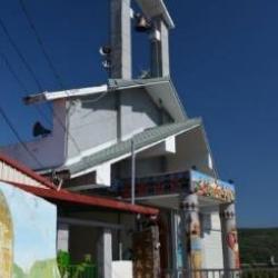
The ancestral spirit house is the most sacred place for the Paiwan people. Each clan has its own ancestral spirit house. During the millet harvest festival and the five-year festival, people from the same clan will return to the ancestral spirit house to reunite. In addition, each tribe has its own ancestral house. During the festival, priests, shamans, and leaders perform various ceremonies there, and outsiders are not allowed to participate. The ancestral spirit house is built with stone slabs. Except for the most important ancestor statues, there is almost no other furniture inside the house. Only wooden frames are nailed to the surrounding walls, on which are placed precious earthen pots, copper pots and other collectibles. In addition, vine balls and sharpened poles from the five-tear festival, tusks of wild boars, skulls, eagle feathers, claws, and teeth of the bears are also collected in the ancestral spirit house to pass on to future generations. There are two ancestral houses in Kulou Village. The earliest cinekecekan is located at the turning point of Zhongshan Road. Later, due to the increasing population in the village, the hunting ancestral spirit house (rusivawan) was added on the side of Zhongzheng Road.
paiwan
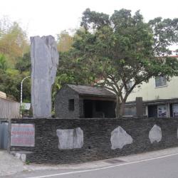
At the entrance of the Kulou community in Laiyi Township, Pingtung County, there is an image of Maljeveq, the vine ball ceremony of the five-year festival, and the surrounding black marble stone wall is decorated with stone carvings. One of the highlights of the five-year festival is the vine ball ceremony. In the past, the ball used in the ceremony is woven with vines, but now it is woven with acacia bark into a ball with a diameter of about 12 cm. Usually, about 200 balls are prepared for a five-year festival, some of which are blessed by shamans and priests and used in the vine ball ceremony, while others are used for practice. A twine is attached to the vine ball, which is used to throw the ball higher. The length of the thorn is 15 meters, so the ball must be thrown at least 18 meters high, not only high but also straight. When the ball is caught by the sharpened pole, it is an honor to take the "sacred ball" home and enshrine it in the ancestral house.
Daren Township was originally Fan area of Taitung County during the Japanese rule and was placed under the administrative control of Dawuzhuang. After the war, the Nationalist government established the Taitung County Government, made the former-ruled Fan area a mountainous administrative control area, and established Sandi Township. This township was divided from the Dawu Township administrative area in 1946 and named "Daren Township". The township office was first set up in Tuban village. Due to inconvenient transportation, it was moved to Fuxing Road, Anshuo village in 1958. The indigenous groups in the township include Paiwan, Rukai, Pinuyumayan, Amis, and so on, accounting for more than 90% of the township's population. The township has six villages under its jurisdiction: Anshuo and Nantian are close to the sea, while Morinaga, Xinhua, Tuban, and Taiban are located in the higher inland mountainous areas.
The residents of this hamlet were originally residents of old Dagu (Tjarilik) and neighboring Gutanas and Enivaian hamlets. They moved here in 1953 due to the inconvenience of living in a steep mountainous area. The tribesmen of old Dagu hamlet chose to live on the land where Morinaga Hoshinaen Co. Ltd. specialized in planting quinine, coffee, and tea during the Japanese occupation. Later, this hamlet was named Senyong (Morinaga) after the farm. Tjarilik, the name of the old tribe of the Paiwan people, means steep mountains, while Gutanas means the tribe on the cliff, and Enivaianmeans a place with big and sacred trees.
The residents of this hamlet were originally residents of old Dagu (Tjarilik) and neighboring Gutanas and Enivaian hamlets. They moved here in 1953 due to the inconvenience of living in a steep mountainous area. The tribesmen of old Dagu hamlet chose to live on the land where Morinaga Hoshinaen Co. Ltd. specialized in planting quinine, coffee, and tea during the Japanese occupation. Later, this hamlet was named Senyong (Morinaga) after the farm. Tjarilik, the name of the old tribe of the Paiwan people, means steep mountains, while Gutanas means the tribe on the cliff, and Enivaianmeans a place with big and sacred trees.
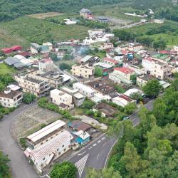
Qijia hamlet, or Tjuvecekadan in the Paiwan language, has the meaning "central", because old Qijia hamlet is located between Gulou hamlet and Lili hamlet, and is in the middle of surrounding mountains and rivers. The origin of this tribe came from the padain (old Gaoyan) in the north, and then migrated to kaviangan. Later, the ancestor simerangan (the curimudjuq family) led the tribe to karuvuan (old Guichong). On one hunting occasion, when the people arrived at old Qijia the hunting dogs refused to leave. Thus, they settled down in Tjuvecekadan (Old Qijia) for at least 400 years. It was until 1961, the government moved the old Qijia to Tjukarangan in order to promote the housing improvement plan for the indigenes. In 1972, due to the severe damage caused by Typhoon Rita, the Tjukarangan (Qijia hamlet then) and other hamlets such as Guichong and Lili moved to the current location of Tjuadresir (Jialiliao), and they are collectively called Qijia Community.
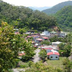
Jialaban hamlet, or qaljapang in the Paiwan language, is located on the river terrace next to the confluence of the Jialaban River and the Dawu River. The residents were mainly from the old Jialuoban settlement, and some were from the original Chachayadun settlement. When heading west from Dawu into the Jingshuiying Trail, Jialuoban is the last settlement. In the 1970s, the residents of Jialuoban used to grow citronella. At that time, the essential oil of citronella was exported, and the income was good. With the improvement of economic conditions, the residents rebuilt their houses. Therefore, almost all the residents of Jialuoban now live in brick houses. Presently, residents grow watermelons and gourds on sandy lands by Dawu and Jialaban Rivers.
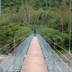
The Guzilun suspension bridge that was used to cross Chachayadun River during the Japanese rule was erected in the 6th year of Taiso (1917). At that time, the Guzilun police post was located on the north bank of the Xidi campsite (Miaopu) of the Qing Dynasty, so the suspension bridge was called the Guzilun Bridge. In the 7th and 8th years of Taisho (1918 and 1919), the suspension bridge was damaged twice by typhoons. In the 14th year of Taisho (1925), the suspension bridge was re-erected. The remnants of the suspension bridge seen today were rebuilt in the 15th year of Taisho (1926). Today, only the cement bridge girder remains intact. When the Forestry Bureau set up the national trail here, an iron suspension bridge was erected for the use and safety of visitors.
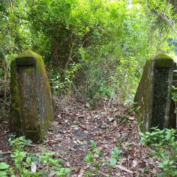
The Guzilun suspension bridge is erected on the Chachayadun River, and was one of the important suspension bridges on the Jingshuiying Trail. The bridge was erected in the 6th year of Taisho (1917). At that time, the Guzilun police post was located on the north bank of the Xidi camp site (Miaopu) of the Qing Dynasty, so the suspension bridge was called the Guzilun Bridge. In the 7th and 8th years of Taisho (1918 and 1919), the suspension bridge was damaged twice by typhoons. In the 14th year of Taisho (1925), the suspension bridge was re-erected. The remnants of the suspension bridge seen today were rebuilt in the 15th year of Taisho (1926). Today, only the cement bridge girder remains intact. Around the bridge girder, the iron wires used for the suspension bridge at that time can still be found. On the bridge girder, there are engravings of the words “Completed in March 15th year of Taiso”.
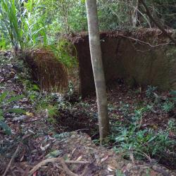
According to Yang Nanjun’s investigation, the Forestry Bureau has contracted locals to make charcoal from miscellaneous wood since 1959. Therefore, in the 1960s, there were many charcoal kilns on the Jianshuiying Historic Trail. At present, there is a ruin of a charcoal kiln below the historic trail located 550 meters north of the eastern edge of Chushuipuo mountain. The kiln is a circular structure with a diameter of about 4.8 meters, a rammed earth wall height of 2.1 meters, and a thickness of 0.8 meters. There is a kiln door and a small window hole for checking charcoal firing. After the charcoal kiln is filled with wood, the top and the kiln door are covered and sealed with clay. The rammed earth wall around the charcoal kiln is hardened due to high temperature.