Shuishalian

Xingtianzheng
向天圳往日月潭方向的水道

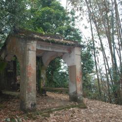
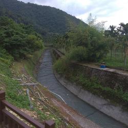
Xiangtianzhen is a section of an underground tunnel, located in Yuchi Township, Nantou County. It was built during the Japanese Occupation period by the Government-General in Taiwan when the Sun Moon Lake hydroelectric power project was constructed. The underground tunnel, which is about 15 kilometers long, was built to induce water from the blocked Zhuoshui River into the tunnel and then into Sun Moon Lake. This underground tunnel is called the Wujie Channel. However, a section of the tunnel is on the ground because when passing through the riverbed of Muzilan Creek, the riverbed is lower than the tunnel itself. Therefore, an elevated channel is adopted to pass the stream. Since this section is on the ground and open air, it is called Xiangtianzhen, meaning facing the sky.


Centennial Monument Pavilion of the Establishment of Dongguangjian Village
位在東光派出所門口的東光建村百年紀念碑亭

The Centennial Monument Pavilion of the establishment of Dongguangjian Village is located in front of the Dongguang Police Station in Yuchi Township, Nantou County. It was established in 1957 and records the establishment process of Dongguang Village, including reclamation, defense, and appeasement of the indigenes.


Ita Thao (Pujishe)
從伊達邵碼頭遠眺碼頭邊的商店街

Ita Thao, located in Yuchi Township, Nantou County, was called Bu Ji or Huafanshe during the Japanese Occupation. In 1934, the Government-General in Taiwan began the construction of the Sun Moon Lake Hydropower Project. The Thao people were forced to move away from their original settlements. When the Sun Moon Lake Reservoir was completed, they began to actively develop tourism in the area. The Thao people’s traditional pestle song and dance performances became a selling point for attracting tourists. They also invested in canoes and sold handicrafts, which caused a rapid change in the economic life and social organization of the Thao people.

In the postwar period, the National Government changed its name to Dehuashe. It was not until 2000, when the Thao became the 10th officially recognized indigenous group in Taiwan, that it was renamed Ita Thao.

Lalu Island
從涵碧半島遠眺湖中圓形的拉魯島,浮田圍繞於四周

Lalu Island is located in Sun Moon Lake, Yuchi Township of Nantou County. The traditional Thao name is Lalu, but it was called Zhushan or Zhuzishan (literally meaning Pearl Mountain) during the Qing period, as it is shaped like a pearl. In the Japanese Occupation period the island was renamed Yudao or Nakanoshima (literally meaning round island or center island). Then, in the postwar period, the Nationalist Government changed the name to Guanghua Island in the sense of restoring China. Finally, it was officially renamed Lalu Island in year 2000 because this is the traditional area of ​​the Thao people.

The people believed that the highest ancestor spirit lived in the big tree on Lalu Island. Therefore, the island is no longer open to tourists. Tourists can admire the installations related to the Thao cultural display and historical development from the pontoon plank road on the water around the island.

Sun Moon Lake
水社壩旁的日月潭風景

Sun Moon Lake, in Yuchi Township of Nantou County, is surrounded by Shuishe Mountain, Buji Mountain, Yiji Mountain, Tantou Mountain, Songlun Mountain and Maolan Mountain. It was originally a natural lake, formerly known as Shuili Lake, Shuishe Lake, Longtan or Dragon Lake.

During the Japanese Occupation, in order to use Sun Moon Lake to generate electricity, the Government-General in Taiwan built Shushe Dam and Toushe Dam to increase the reservoir capacity, and then built a 15-kilometer underground channel from the Zhuoshui River channel closest to Sun Moon Lake to block sand and intercept stream water. The overall reservoir construction project was completed in 1934.

Today, the Sun Moon Lake Reservoir has the most complex hydroelectric power generation system in Taiwan, which is used daily through Taipower's pumped-storage power generation.

Shuishe Dam
從水社壩遠眺水社方向,公路底下即為水社壩

Shuishe Dam is located next to Sun Moon Lake in Yuchi Township, Nantou County. It mainly regulates the water volume between Sun Moon Lake and Ming Lake. When the water flows down to Ming Lake, Mingtan Power Plant can generate electricity. Outside peak time at night, the water gets pumped back to Sun Moon Lake again. Shuishe Dam has a plank path along the road, which is about 200 meters long, and is a favorite spot for local residents and foreign tourists.


Monument of Sacrifices
日月潭水力發電所工程殉難碑正面刻有殉難碑的字樣

The Monument of Sacrifices of the Sun Moon Lake Hydropower Station is located near the top of the Sun Moon Lake dam, on Provincial Highway 21 in Yuchi Township, Nantou County. It was established in 1934 to commemorate the Taiwanese laborers who died during the construction of the plant.

Specifically, the front of the stone monument is engraved with the words of the martyrdom monument, and on the back is the description of the reason for the monument. Both sides of the monument have the addresses, names and ages of the victims engraved on. Most of the victims are from the nearby Yuchi village and Puli Street, 13 people altogether.

Trail Entrance from Benggui Starting Point
從銃櫃至水里路段的登山入口,路旁設有土地公鞍的指示牌

The trail entrance that starts from Benggui is located in Yuchi Township, Nantou County. There are signs indicating the Tudigong Saddle along the road. 

This Shuishalian Historic Trail, which spans across Puli Township in the north and Shuili Township in the south, is located in Nantou County and has a total length of about 29 km. The date of construction is unknown and today the only section left from the trail is from Shuili to Gungui via Erping. The trail is also known as the Tudigong Anling Trail because there is a Tudigong Temple on the ridge saddle.

Since the Qing period, the Shuishalian Historic Trail has been an important route for Han people to enter the Toushe Basin, Puli Basin, and Sun Moon Lake Shuishe. Due to migration and trade needs, the Han immigrants, Pingpu group and indigenous groups actively used this trail. In the early days of the Japanese occupation period, the Shuishalian Historic Trail was regarded as an important barrier defense line, and set up policing stations. 


Ruins of Tudigong Temple
水沙連古道的土地公鞍上,保留一座廢棄的土地公廟

The Tudigong Temple ruins is located on the section between Shuili to Benggui of the Shuishalian Historic Trail, on the Tudigong Saddle at an altitude of about 640 meters. There are remnants of earlier buildings behind the temple ruins, and the original Tudigong statue has been moved to Futian Temple in Yuchi Township, Nantou County. 

Shuishalian Historic Trail straddles across Puli Township and Shuili Township of Nantou County, with a total length of about 29 km. The trail is also known as the Tudigong Anling Historic Trail. The construction date is unknown but since the Qing period, the Shuishalian Historic Trail was an important route for the Han people to enter the Toushe Basin, Puli Basin, and Sun Moon Lake Shuishe. In the early days of Japanese rule, it was regarded as an important barrier defense line with policing stations.

Tudigong Saddle
從水里到銃櫃路段上的土地公鞍,建有一座廢棄的土地公廟

The Tudigong Saddle is located on the section between Shuili and Benggui of the Shuishalian Historic Trail, about 640 meters above sea level. On the saddle there is an abandoned Tiangong Temple and behind it are remnants of earlier buildings.

Shuishalian Historic Trail straddles across Puli Township and Shuili Township of Nantou County, with a total length of about 29 km. The trail is also known as the Tudigong Anling Historic Trail. The construction date is unknown but since the Qing period, the Shuishalian Historic Trail was an important route for the Han people to enter the Toushe Basin, Puli Basin, and Sun Moon Lake Shuishe. In the early days of Japanese rule, it was regarded as an important barrier defense line with policing stations.