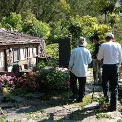
Old Haocha

Attractions along Wutai Haocha Historic Trail

Haocha was originally called Kochapongan, and it was recorded as "Jia Zhebangan" or "Jiapogan" in Qing Dynasty documents, and it was recorded as Koetapongan in the Dutch indigenous household records. After the Liberation of Taiwan, the place was renamed “Haocha” or transliterated as “Guchabu’an”. It is the center of the original settlement of the Rukai people in the west and includes Wutai, Ali, and other settlements, which all stemmed from it. Regardless of the historical background or cultural tradition, they all occupy a very important position.

  • - / -
  • - - -
  • -
  • - -/-
  • -
In May 2009, Chen Yonglong, Sasala Taiban, and others inspected the preservation of the existing slate houses of the Old Haocha village.
According to Yang Renjiang's research, the houses of the old Haocha village were built along the hillside in accordance with the terrain, and there were around 150 houses. The main houses are mostly rectangular, and the main building materials are gray-black slate and shale, which are commonly known as slate houses.
The settlement of "Old Hoacha" is on a slope at an altitude of 970 meters that is located north of the confluence of the upper right bank of the South Ailiao River and its tributary, Dalagalen stream, and south of Mount Jingbu. The settlement is about 2,500 meters away from the South Ailiao River Valley. The terrain is wide in the east and narrow in the west and you can see the Shangpaiwan, Pinghe, Bailu, and other communities of the Paiwan people across the river.
古道地圖
沿途景點所在位置
沿途景點所在縣市
屏東縣
沿途景點所在鄉鎮
霧臺鄉