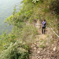
Trail along the cliff wall

Attractions along Wutai Haocha Historic Trail

Whe the mountain trail was in good condition, before the Morakot typhoon disaster hit on August 8, 2009, it took around 3 to 4 hours walk along the right bank of Ailiao River  to reach the old Haocha village from new Haocha. After the typhoon in 2009, the trail leading to old Haocha was cut off. After several explorations and investigations by the tribesmen, the old trail was repaired, the falling rocks were removed from the road, and ropes were erected on the cliff, which made the trail passable again.

At present, to get to old Haocha you need to go through the Taiwan Indigenous Peoples Cultural Park in Majia Township, arrive at the end of the Haocha industrial road, and walk along the south Aliao River for about 3.4 kilometers to reach the flooded area of ​​the new Haocha village. Continue for another 1.3 kilometers to reach the old hiking entrance and then  follow the traditional route to old Haocha. The difference in altitude is about 830 meters. Some sections of the road are cliffs, which are extremely dangerous, and the whole journey takes around 7 hours to complete.

  • - / -
  • - - -
  • -
  • - -/-
  • -
This image, taken in May 2009, shows  a member of the ancient trail survey, Zhang Shude, leaving the Old Haocha village and on the way to the second waterfall from the Taiwan beech resting area. The  trail is only about one meter wide, with the South Ailiao River in the valley below on the left. Without caution you  may fall. Thus, the tribesmen erected thick ropes on the cliff wall in providing safety support for hikers.
This image, taken in May 2009, shows a member of the ancient trail survey, Zhang Shude, leaving the Old Haocha village and on the way to the second waterfall from the Taiwan beech resting area. The trail is only about one meter wide, with the South Ailiao River in the valley below on the left. Without caution you may fall. Thus, the tribesmen erected thick ropes on the cliff wall in providing safety support for hikers.
古道地圖
沿途景點所在位置
沿途景點所在縣市
屏東縣
沿途景點所在鄉鎮
霧臺鄉