Wutai

Attractions along Wutai Haocha Historic Trail

The Wutai settlement is located in the northeast of what is today’s Wutai Village, that is, on the gentle eastward slope of Mount Jingbu on the left bank of the North Aliao River, with an elevation of about 800 meters. Since the middle to late Japanese occupation period, it has become the administrative center of the region with a township office, police station, health center, and schools. In the Rukai language of Wutai community Wutai is called Vudai, Taibabao, or written as Budai. The original meaning of the name is unknown but since the Chinese character is written as “fog platform”, it was thought that the name comes from the year-round fog in the area. As a fact, job’s tears grow luxuriantly here, and this plant is named Budai in Rukai language. 

  • - / -
  • - - -
  • -
  • - -/-
  • -
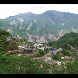
This image shows the Wutai settlement after the Morakot typhoon disaster in 2009. The bare mountain wall in the distance was caused by the enormous rainfall during the typhoon.
Aerial shot of Wutai settlement.
An aerial view of the Wutai village, which is now the most significant tribal community in Wutai Township. With the development of tourism, it has also been designated as a "homestay village".
Aerial shot of Wutai settlement, where there is Wutai Elementary School, police station, health clinic, post office, and other public facilities.
古道地圖
沿途景點所在位置
沿途景點所在縣市
屏東縣
沿途景點所在鄉鎮
霧臺鄉