Wutai Haocha Historic Trail

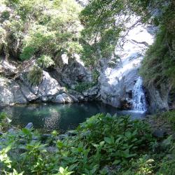
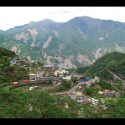
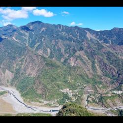
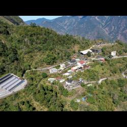
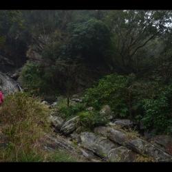
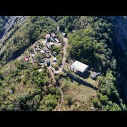
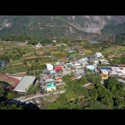
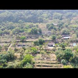
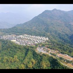
Located in Wutai Township, Pingtung County, Wutai Haocha Historic Trail begins at Zhenxing Village, Yanpu Township, which is on the edge of the Ailiao River. The trail is about 27.9 km long, and passes through villages in Sandimen, Wutai and Old Haocha. At the same time, crossing the Ailiao South Creek to arrive at villages in Majia, Beiye Townships and other places.


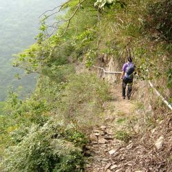
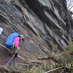
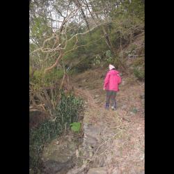
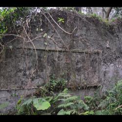
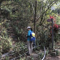
During the Japanese occupation, the Wutai Haocha Historic Trail was only the width of a footpath. Today, part of the trail that departs from Sandimen has been widened and made into the Provincial Highway 24 leading to Wutai, while most sections of the trail have collapsed. Currently, there is still about 1 km of walkable trail remaining, which extends from the trail entrance that is next to the water source of the abandoned Haocha Elementary School.

  • - / -
  • - - -
  • -
  • - -/-
  • -
霧臺、好茶古道封面照
霧臺、好茶古道封面照
霧臺、好茶古道封面照
Birds’ eye view of Rinari Village
Birds’ eye view of RInari Village. Majia Village is on the left, while Haocha Village is on the right.
Birds’ eye view of old Dalai Village. Top left is the police station, school and other administrative center.
Birds’ eye view of old Dalai Village
Birds’ eye view of old Dalai Village. You can see the neatly stacked slabs of arable land below.
Chizhi Slope, the trail entrance that leads to old Dalai Village.
Chizhi Slope, on the way to old Dalai Village.
Birds’ eye view of Shenshan Village
Birds’ eye view of Qulu (Kinuran) Village. The ground was severely destructed by Typhoon Morakot
Birds’ eye view of Qulu (Kinuran) Village. The ground was severely destructed by Typhoon Morakot.
Nanban Shigesuke Monument that stands on the platform behind Jiuhaocha Elementary School.
The back of the monument with the date of death engraved.
A classroom blackboard in Jiuhaocha Elementary School that still has green blackboard paint.
Ruins of a classroom blackboard in Jiuhaocha Elementary School.
Walls and beams left from a Jiuhaocha Elementary School classroom
Ruins of Suspension Bridge next to Old Haocha Water Source
Historic Trail next to Old Haocha Water Source
Ladenge rest area, on the way to old Haocha Village

古道地圖

Attractions
Carved eave by Lidaku
力大古雕刻的簷桁
Carved eave by Lidaku資訊

The image is of carved eaves in front of the house of Lidaku Mabaliu (1902-1990), who was the most well-known sculptor and blacksmith of the Haocha village in modern times. To protect it from being damaged by wind and rain, it is currently tucked away inside a slate house in the village that has a complete roof. The head pattern carved on these eaves can resemble the head of Lidaku as he intentionally or unintentionally projected part of himself in the works. After moving away from old Haocha village, Lidaku was the first to have returned to rebuild his hometown. He was a living dictionary that witnessed the rise and fall of the Haocha village in the past century and is a typical representative of the Rukai tradition and modern society.

Taiwan Beech
紅櫸木(Tinivai)休息平臺,位於海拔約830公尺處,舊好茶部落的入口處。
Taiwan Beech資訊

The Taiwan beech (Tinivai) resting platform is located at the entrance of the old Haocha village at an altitude of about 830 meters. There is a Taiwan beech with a thick trunk of about 1 meter in diameter and a height of 6 meters. There are stacked slate stools under the tree. The platform faces the valley, overlooking the South Aliao River. Today, the Taiwan beech (Tinivai) is an important landmark on the way to the old village for the tribesmen. Before migrating away from the village, it was also the resting place between old Haocha and the plains in the west. It takes about an hour and a half to go from the Taiwan beech to old Haocha. After passing the resting place, you can see the village in the distance.

Trail along the cliff wall
影像為2009年5月古道調查成員張書德離開舊好茶部落,於紅櫸木前往第二瀑布途中險峻道路的景色,道路的路幅約只有一公尺寬,影像左側深谷為隘寮南溪,稍有不慎即可能跌落,部落族人於山壁上打樁固釘,架設防護用的粗繩提供行人抓扶,以確保安全。
Trail along the cliff wall資訊

Whe the mountain trail was in good condition, before the Morakot typhoon disaster hit on August 8, 2009, it took around 3 to 4 hours walk along the right bank of Ailiao River  to reach the old Haocha village from new Haocha. After the typhoon in 2009, the trail leading to old Haocha was cut off. After several explorations and investigations by the tribesmen, the old trail was repaired, the falling rocks were removed from the road, and ropes were erected on the cliff, which made the trail passable again.

At present, to get to old Haocha you need to go through the Taiwan Indigenous Peoples Cultural Park in Majia Township, arrive at the end of the Haocha industrial road, and walk along the south Aliao River for about 3.4 kilometers to reach the flooded area of ​​the new Haocha village. Continue for another 1.3 kilometers to reach the old hiking entrance and then  follow the traditional route to old Haocha. The difference in altitude is about 830 meters. Some sections of the road are cliffs, which are extremely dangerous, and the whole journey takes around 7 hours to complete.

Stone carving in front of Lidaku’s house
影像為近代好茶部落最負盛名的雕刻師及鐵匠LidakuMabaliu(力大古,漢名蔡旺,1902-1990)的家屋前所立的石雕,其石雕似一個人的微笑,或可解讀為雕刻者自我形象的反射。
Stone carving in front of Lidaku’s house資訊

After being moved away from old Haocha, Lidaku was the first old man to have returned to rebuild his hometown. He was a living dictionary that witnessed the rise and fall of the Haocha village in the past century and is a typical representative of the Rukai tradition and modern society.

Lidakuu was born in old Haocha in 1902. His father and grandfather were both outstanding sculptors of the tribe. He had been educated since childhood, and with his natural artistic talent, he was able to take his father’s place at the age of fifteen after his father passed away. Like most traditional Rukai carvers, Lidaku did not learn as an apprentice. His woodcarving skills stemmed from actual life experience and self-exploration. In addition to the large-scale wood carvings commissioned by the nobles, the themes of his creation related to the life and religion of the Rukai people.

Water Source
水源地一隅
Water Source資訊

The image shows the water source (Drakerale) behind the old Haocha village. The water source is the lifeblood of the village and comes from Mount Jingbu, which can be reached by crossing a small saddle behind the school. The water source is about 1,000 meters above sea level and is a deep pond with a waterfall. The water is clear and sweet. According to Chen Yonglong's research, the old water source was not only the place where water is collected,  but also where the tribesmen set out strict rules on how water is used. They carried out the order of their washing in the upper or lower sections of the stream based on the level of cleanliness and dirt from daily life. For example from up to downstream, the sequence was drinking water, bathing, laundry, a place for washing blood during women's menstrual period, a place for cleaning prey, and soaking enemy’s heads. They also have separate time for women and men to use the water. For example, women use the water for laundry, bathing, and washing menstrual blood in the morning while men use it in the afternoon. The same space becomes a different social space under the time division.

Old Haocha
2009年5月陳永龍與臺邦‧撒沙勒等人檢視舊好茶部落既存石板屋保存狀況。
Old Haocha資訊

Haocha was originally called Kochapongan, and it was recorded as "Jia Zhebangan" or "Jiapogan" in Qing Dynasty documents, and it was recorded as Koetapongan in the Dutch indigenous household records. After the Liberation of Taiwan, the place was renamed “Haocha” or transliterated as “Guchabu’an”. It is the center of the original settlement of the Rukai people in the west and includes Wutai, Ali, and other settlements, which all stemmed from it. Regardless of the historical background or cultural tradition, they all occupy a very important position.

Haocha Chapel
影像為舊好茶部落的教會禮拜堂,鄰近道路之前牆與背牆以鋼筋混凝土建築。
Haocha Chapel資訊

This chaple was built around the 1960s. In the early postwar period, under the influence of the changing customs policy during the Japanese occupation, traditional Haocha rituals gradually declined. As a result, some ceremoniy related spaces, such as spiritual houses or shrines, gradually lose their meaning due to the loss of support for activities. Since Christianity was introduced into the Haocha village in the 1950s, the beliefs of many Haocha people have changed with a very high percentage of residents believing in Christianity. With Presbyterian first entered Haocha preaching in 1950, the Catholics also came to spread the gospel in 1952, and then in 1956, Seventh-day Adventist missionaries entered the tribal mission, the initial preaching of the gospel was challenged by primitive beliefs and the opinions of tribal leaders. After that, churches such as the Presbyterian Church, the Sabbath Church, and the Methodist Church appeared one after another in the settlement. Most of these churches were rebuilt from the vacant houses of the migrants. During this period, the traditional beliefs and spatial views of Haocha people changed drastically.

Yila
2009年莫拉克風災後所拍攝的溪底便道及伊拉部落,莫拉克風災後隘寮北溪旁伊拉橋被洪水沖毀,通往霧臺山區的交通中斷,工程單位緊急利用水泥涵管架設臨時溪底便道,方便山區部落通行。
Yila資訊

The original meaning of Ira (Yila village), or Kurgul or Kurag in the Paiwan language, is unknown. The "Takasago Survey Book" from the Japanese occupation period pointed out that this settlement lived in the Tabataban settlement about 270 years ago, and because of the increasing population, the reduced arable land, lest it not possible to maintain the survival of a community in the future. At that time the three sons of the leader each chose a place to move to. One of the three sons and some tribesmen moved to the old settlement site to form the current settlement. At resent, the settlement is located on the left bank of the north Ailiao River, north of Mount Tianliangjing, below the east side of Provincial Highway 24, on the slope of the gently sloping river bank with an elevation of about 300 meters, is the westernmost settlement of the whole township. It was formed in 1955 by the relocation of the old settlement. The old settlement is located above the south side of the current site, on a slope with a slightly higher terrain of about 330 meters.

Wutai
影像為2009年莫拉克風災後所拍攝的霧臺聚落,因莫拉克風災帶來驚人雨量,加速山壁的沖刷、侵蝕,遠方山壁大量土石滑動及山崩,造成山壁崩塌光禿一片。
Wutai資訊

The Wutai settlement is located in the northeast of what is today’s Wutai Village, that is, on the gentle eastward slope of Mount Jingbu on the left bank of the North Aliao River, with an elevation of about 800 meters. Since the middle to late Japanese occupation period, it has become the administrative center of the region with a township office, police station, health center, and schools. In the Rukai language of Wutai community Wutai is called Vudai, Taibabao, or written as Budai. The original meaning of the name is unknown but since the Chinese character is written as “fog platform”, it was thought that the name comes from the year-round fog in the area. As a fact, job’s tears grow luxuriantly here, and this plant is named Budai in Rukai language. 

Dawu
影像為吉露部落空拍上下大武聚落
Dawu資訊

In the image, the settlement on the left is the lower Dawu settlement, also known as the little mountain alley of lower Dawu. It is located southwest of Wutai village, on the flat platform on the right bank of the upper reaches of north Ailiao River, with an altitude of about 460 meters. The name “little mountain” may have come from the terrain where the settlement is located. Shiderao, or as it is transliterated as "Delau", is the main settlement. In the 6th year of Taisho (1917), due to disputes with other communities and got severely criticized by the chief, the settlement was formed by relocating the Wutai community. There were only 10 households in the 6th year of the Showa era (1931).
The settlement on the right is upper Dawu, also known as Dongchuan Alley. It faces Little Mountain Alley across the stream. The settlement is distributed on a flat platform with an elevation of about 500 meters. It got its name from being located on the east bank of the stream. In the 6th year of the Showa era (1931), there were in total 50 households with 270 people. It was the settlement closest to the central mountain range at that time, and traveling in and out was extremely inconvenient.

Ali
影像中左側建築物為阿禮聚落的墓園,右側聚落為阿禮Swaumouman聚落,影像中可見部落派出所、國小及村辦公室均集中於此處。
Ali資訊

Ali settlement is located in the west corner of Ali Village, northeast of Kaligutsan (Mount Jingbu), west of Mount Yadini, on the left bank of Adel River, on a steeply sloping slope with an altitude of about 1200 meters. The Zhiben traversing trail from the Japanese occupation and today’s provincial highway 24 pass under the settlement, and is currently the settlement located on the highest point among the Paiwan and Rukai people. There are two settlements, Swabaliu and Swaumouman, north of Swabaliu.
 At present, the police station, elementary school, and village office are all located above the latter. Ali is Adel community, the Japanese call it shiyader, while in the Rukai language it is called Adithi, which refers to the people around the sharp fog-headed peaks.

Tjavatja Church
影像為舊達來部落(Eceecengan)臺灣基督長老教會排灣族達瓦達教會的第三代禮拜堂遺跡。
Tjavatja Church資訊

After the war, more and more people in the old Dalai village converted to Christianity and began regular worship on February 5, 1950. At first, the worship took place at the house of Paljius (Pastor Lin Jianer). Due to the increasing number of believers, the house of Paljudasgiljgiljaw, who had moved away, was purchased as the church’s first place of worship. The construction began in September 1952 and was completed on December 25 of the same year with thatch as the building material. As the number of believers grew and the church could no longer accommodate them. Kavuaran Ke Yishun donated his own land for the building of the new church. The construction started in January 1957, using wood and stone slabs as building materials. It was completed at the end of June of the same year, and the church was dedicated on July 15. This was the second church. 

The third church began construction on December 7, 1965, with red brick walls and lead roofs. It was completed on April 24, 1966, and was dedicated for the third time on August 2. The bricks and tiles of the church were completed by the tribesmen because in the past when traffic was not well developed, everyone in the village participated in voluntary labor participated. Each household transported bricks from the bottom of the mountain to the mountain on foot every week.

Ladenge Rest Area
前往舊好茶部落山徑途中的石壁(Ladenge)休息區
Ladenge Rest Area資訊

Ladenge Rest Area is located one-third of the trail on the way to old Haocha Village.  Along the way, the wrinkled patterns on the rock wall are clearly visible. Once you have passed the rock walls, the path narrows and there are stairs that make the walk easy. Continue on for another 20 minutes and you will arrive at the slate house. Today, entry to old Haocha Village is from the Taiwan Indigenous Peoples Cultural Development Center in Majia Township, Pingtung County. After reaching the end of the Haocha industrial road, walk along Ailiao North River and you will first arrive at the once-flooded new Haocha Village. It then takes about 1.3 km to reach the old entrance for the trail. The altitude difference of the whole journey is about 830 meters, and some sections of the trail are cliffs, which are extremely thrilling.

Historic Trail next to Old Haocha Water Source
舊好茶部落水源地旁的古道
Historic Trail next to Old Haocha Water Source資訊

Wutai Haocha Historic Trail entrance is located next to the water source of the Old Haocha Elementary School and is about 1,000 meters above sea level. Most parts of the trail have collapsed, leaving only about 1 km of the historic trail left for passage. Currently there is a suspension bridge ruin and the stone-stacked road is complete. The original starting point of the Wutai Haocha Historic Trail was located in Zhenxing Village, Yanpu Township, Pingtung County, and passes through Sandimen, Wutai and Old Haocha successively. It has a total length of about 27.9 km. During the Japanese occupation, the trail was designed for connecting villages. Today, the section that starts from Sandimen has been widened and became the Provincial Highway 24 leading to Wutai.


Suspension Bridge next to Old Haocha Water Source
舊好茶部落水源地旁的吊橋遺跡
Suspension Bridge next to Old Haocha Water Source資訊

The remains of the suspension bridge next to the water source of the old Haocha Village is about 1,000 meters above sea level. Although the bridge has been destroyed, you can still see the main iron cable of the suspension bridge that spans across the stream. Heading down the mountain along Wutai Haocha Historic Trail you will reach Sandimen. To this day, at the trail entrance next to the water source of the abandoned Old Haocha Elementary School, there is still a complete stone-stacked road. However, there is only about 1 km of walkable historic trail remaining, and the rest have collapsed.

Jiuhaocha (Old Haocha) Elementary School
漆面脫落的舊好茶國小教室黑板
Jiuhaocha (Old Haocha) Elementary School資訊

The Old Haocha Elementary School, located in Wutai Township, Pingtung County, is currently abandoned. The ceiling of the building collapsed, leaving only the walls, beams, pillars, and overgrown grass. During the Japanese occupation, the Government-General in Taiwan set up a police post and educational institution on the edge of the Old Haocha Village in the east with the aim to transfer tribal power through the entry of state power, and to become the main authority to manage the village. Also, to stabilize tribal governance through national education and teaching village children Japanese.  In the post-war period, the National Government established independent villages based on each police post, and the original educational institute was restructured into the Haocha Public School.

Nanban Shigesuke Monument
南幅重助紀念碑的陰面刻有死亡日期
Nanban Shigesuke Monument資訊

The Nanban Shigesuke Monument is located at the back of Old Haocha Elementary School, on a path that leads to the village’s water source. The monument is made of two large stones stacked together and is 2 meters tall. The words, “Nanban Shigesuke Monument”, are engraved on one side, while the date of death, June 20 Showa 9, is engraved on the other. This monument mainly commemorates Nanban Shigesuke, who served as the head of the Kochayabokan Police Post during the Japanese occupation and ended his life on June 20, 1934.

However, in the post-war period, the National Government filled the monument with cement, painted in white and wrote in blue “Do not forget national humiliation in time of peace and security”. As time went by, the cement that had been smeared gradually eroded and the inscriptions from the Japanese occupation gradually re-emerges.


Qulu (Kinuran) Hamlet
從空中俯瞰去露部落,地基因莫拉克風災嚴重滑落
Qulu (Kinuran) Hamlet資訊

Qulu Hamlet in Wutai Township, Pingtung County, is located below Provincial Highway 24. The terrain generally descends from south to north. During the Japanese occupation, Qulu Hamlet only had 38 households with 197 people. It was a relatively small tribe. The traditional Rukai name for the hamlet is Kinuran. After the war,  the National Government renamed the hamlet and transliterated it as Qunu (“Nu” means anger). Due to the sloping terrain of the tribe and the inconvenience in transportation, some people moved to Sanhe Village in Majia Township. During an inspection in 1967, the chairman of Taiwan Province, Huang Jie, found the name indecent, and instructed to change it to Qulu. “Lu” means morning dew, that nourishes the earth. Sadly, Qulu Hamlet was hit by Typhoon Morakot in 2009 and is now relocated to Baihe permanent housing site in Changzhi.

Shenshan Hamlet
從空中俯瞰神山部落
Shenshan Hamlet資訊

The Shenshan Hamlet is located on the terraced platform on the left bank of Ailiao North River in Wutai Township, Pingtung County, about 700 meters above sea level. 

The traditional Rukai name for the village is Kabararayan. Originally, both Shenshan Hamlet and the neighboring Wutai Hamlet originated from old Haocha Village, and they were cultivated almost around the same time. Later, due to the increasing population, some households of the Shenshan Hamlet moved away and formed the Dewen Hamlet and Jiamu Hamlet respectively. In the post-war period, the National Government combined Shenshan Alley and Zhongshan Alley and formed the Huarong Community, which was later renamed as Shenshan Community by the resolution of the villagers’ representatives in 1982.

Today, the Shenshan Hamlet is divided into two parts, namely the older Swabaliu above the main road and newer Laliulu (aka Swalingolo) below the main road.


Chizhi (Resign) Slope
通往舊達來部落的辭職坡登山入口
Chizhi (Resign) Slope資訊

The Chizhi Slope of the old Dalai Hamlet in Sandimen Township, Pingtung County is located on the left bank of Ailiao North River. Due to the stream, the only way to enter the hamlet was through the Dalai suspension bridge. The name Chizhi Slope (Chizhipuo) literally means resign slope. There is a saying that many civil servants who were assigned to work here ended up resigning because of the steep terrain, and that this was the only passage to the old Dalai Hamlet.

Today, with the administrative support of the Pingtung Forestry Bureau, the hamlet began the restoration of Chizhi slope in 2015. With the help from volunteers of Taiwan’s Thousand Miles Trail Association, and using traditional wisdom of Paiwan people, the restoration was finally complete.

Old Dalai Hamlet
從空中俯瞰舊達來部落,下方可見石板疊砌的整齊耕地
Old Dalai Hamlet資訊

The old Dalai Hamlet in Sandimen Township, Pingtung County, is located on the left bank of Ailiao North River. In the beginning of 1937, the Government-General in Taiwan began the relocation project. The hamlet was relocated collectively at the end of the Japanese occupation. Village residents participated in this labor work and manually leveled land building the police post and education center. The slate materials were transported from Talatalai Hamlet to the old Dalai Hamlet. It took about 5 hours on foot between the two hamlets and finally after the joint effort of the people, the relocation was complete in 1941. The village is organized into a chessboard pattern, with the police station and education center located on higher ground for easy surveillance.

Rinari Village
從空中俯瞰禮納里部落
Rinari Village資訊

Rinari Village in Majia Township, Pingtung County, is located on a plateau stretching from northeast to southwest. It was originally the Majia Farm that belonged to Taiwan Sugar Corporation. Due to Typhoon Morakot in 2009, many villages in the mountainous area of ​​Pingtung were facing safety issues. Therefore, under the plan of the National Government, Majia Village, Haocha Village and Dashe Village, which were adjacent to Majia Farm, were collectively relocated to the farm for resettlement. World Vision then assisted in the construction of permanent houses for those residents. A total of 483 houses were built, and after a discussion from all who participated in this project, the village was named Rinari. Rinari village is Taiwan's second largest permanent residential base.