Indigene Management Facility1

Shu Police Post
曙駐在所下方的古道,道路地基的石砌駁坎整齊

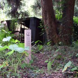
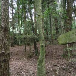
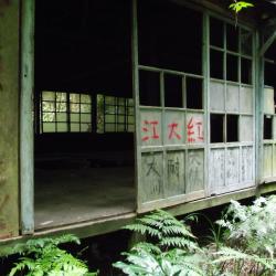
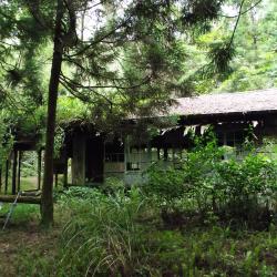
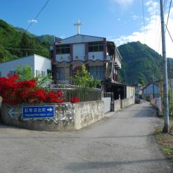
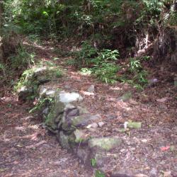
Shu Police Post, in Tai'an Township of Miaoli County, is located at the northeastern foot of Beikeng Mountain, northeast of Erbensong, and at an altitude of about 1,730 meters. It was built in 1923.

The origin of the name, Shu (meaning dawn), is unknown but may be related to the landscape and the rising sun. However, the traditional Atayal name is Mai-leliuk, which means a place where many leliuk trees grow. Leliuk is a hard woody tree of the Fagaceae family. The tree trunk can be used as a hoe handle and ship beams. The fruits are often eaten by flying squirrels, muntjacs, squirrels, and black bears. Therefore, in the past, it was common to see black bears in this area.

Rixiang Police Post
2003年松安派出所尚未拆除的水泥建築

The Rixiang Police Post, in Tai'an Township of Miaoli County, is located at the southeastern foot of Mount Jinwei, east to Xishuishan ridgeline, on the northeastern side of Erbensong, and at an altitude of about 1,410 meters. It was set up in 1923, and was named Rixiang, which means facing the sun, because where the police post stood faces the east. The traditional Atayal name for the place is Ulau-ladin, which refers to the soil being as hard as wood.

To this day, there is still an abandoned industrial building where the Rixiang Police Post used to stand. The ruins of the station can be found behind the building. The Shei-Pa National Park has set up a signpost of the Police Post.


Sign posting for Beikeng Police Post
北坑溪古道由觀霧入山14.6公里處所設立的北坑駐在所指標

The Beikeng Police Post, in Tai’an Township of Miaoli County, was established in 1923. It is located on the 14.6 km point of the Beikeng Creek Historic Trail and is about 1,640 meters above sea level. The traditional Atayal name for the place is Simayen, which means floor-like lawn.

The Beikeng Police Post was originally the administrative center of the Beikeng Creek Historic Trail. There was an education center, Wude Hall, medical facility, places for trades, guns and ammunition depot and so on, of which the buildings still remain on the trail today.

Around 2003, Xuepa National Park renovated the historic trail section from Guanwu to Erbensong, but due to natural disasters, the entire section was still difficult to pass through and was abandoned. Only a few parts of the trail remain.


Beikeng Police Post
北坑駐在所遺址上的木造工寮,刻畫著到此一遊印記

The Beikeng Police Post, in Tai’an Township of Miaoli County, was established in 1923. It is located on the 14.6 km point of the Beikeng Creek Historic Trail and is about 1,640 meters above sea level. The traditional Atayal name for the place is Simayen, which means floor-like lawn.

The Beikeng Police Post was originally the administrative center of the Beikeng Creek Historic Trail. There was an education center, Wude Hall, medical facility, places for trades, guns and ammunition depot and so on, of which the buildings still remain on the trail today.

To get theret, enter from the Simaxian Forest Road in the Xuejian Recreation Area, climb up the Simaxian Forest Road to an altitude of about 2,000 meters, and then descend about 360 meters to arrive at the station.


Beikeng Police Post (Front)
Tayal,泰雅族,理蕃設施,駐在所

The Beikeng Police Post, in Tai’an Township of Miaoli County, was established in 1923. It is located on the 14.6 km point of the Beikeng Creek Historic Trail and is about 1,640 meters above sea level. The traditional Atayal name for the place is Simayen, which means floor-like lawn.

The Beikeng Police Post was originally the administrative center of the Beikeng Creek Historic Trail. There was an education center, Wude Hall, medical facility, places for trades, guns and ammunition depot and so on, of which the buildings still remain on the trail today.

To get there, enter from the Simaxian Forest Road in the Xuejian Recreation Area, climb up the Simaxian Forest Road to an altitude of about 2,000 meters, and then descend about 360 meters to arrive at the station.


Beikeng Police Post (Side)
北坑駐在所遺址上的木造工寮,為戰後林務局所設置的

The Beikeng Police Post, in Tai’an Township of Miaoli County, was established in 1923. It is located on the 14.6 km point of the Beikeng Creek Historic Trail and is about 1,640 meters above sea level. The traditional Atayal name for the place is Simayen, which means floor-like lawn.

The Beikeng Police Post was originally the administrative center of the Beikeng Creek Historic Trail. There was an education center, Wude Hall, medical facility, places for trades, guns and ammunition depot and so on, of which the buildings still remain on the trail today.

To get there, enter from the Simaxian Forest Road in the Xuejian Recreation Area, climb up the Simaxian Forest Road to an altitude of about 2,000 meters, and then descend about 360 meters to arrive at the station.

Hongxiang Village
設立於1958年的紅香真耶穌教會

The Hongxiang Hamlet is located in the foothills of Baigu Dashan in Ren’ai Township, Nantou County. It is 1,170 meters above sea level. The traditional Atayal name of the hamlet is Makanaji. The land is flat and fertile, and most of them have been converted into paddy fields.

In the early days of the Japanese occupation, the tribesmen first moved to the upper reaches of the Makanaji Stream and took refuge when the Government-General in Taiwan sent military police into the hamlet. However, they were forced to relocate to a spot 1.3 km north of the former site of Maisiduobang for better monitoring and management by the Japanese. Later in 1923, they moved to the current location due to the barren land.

Stone steps in Bazai Mountain
拔仔山往那實達社方向路段的石階群

The stone steps in Bazaishan are located in Ruisui Township, Hualien County.

Bazaishan is the first mountain on the eastern section of the Guanmen Historic Trail. The entrance to the trail is in the Fuyuan National Forest Recreation Area. Enter from the industrial road outside the Butterfly Valley, go through the old afforestation path to reach Nasida Hamlet, and the stone steps are on the road to the hamlet.

Due to the steepness, there are many stone steps along the way, especially on the road close to the forest triangle point, where the stone steps are very dense. Road closer to Nashida Hamlet is gentle and therefore, has less stone steps.


Marshland in the east section of Guanmen Historic Trail
拔仔山往那實達社方向路段的石階群

The Guanmen Historic Trail, which straddles Jiji Township of Nantou County and Ruisui Township of Hualien County, began construction in 1886 and completed in the following year. The trail starts from Jiji in the west and reaches Fuyuan in the east, about 105 km in length. It was the last excavated road during the Qing period but was not frequently used by the officials then.

During the Japanese occupation, the trail was used by the Government-General in Taiwan to force the Kashe group and Danshe group of the Bunun tribe to move to a concentrated village.

Nowadays, there is a marshland in the east section of the Guanmen Historic Trail, which is located below the ridge line of Bazaishan. Due to the humid and rainy climate here, many sections of the road are quite muddy. Although the terrain is wide, flat and covered with short grass, the bottom is full of mud and is easy to sink in when walking on it.

Entrace of the former Zhongling Police Post
中嶺警官駐在所入口處的兩根橫木

The Zhongling Police Post, located in Datong Township of Yilan County, was established in 1935 and abolished after the war. The ruins of the police station can be reached by a 3-hour walk starting from the Hapen camp. Then cross the saddle between Mount Zhongling and Mount Hongchai. Alternatively, start from the end of the Lunpi industrial road and it will take around 50 minutes on foot to reach the site.

Today, there are still two horizontal logs and a row of stones, as well as cement foundations and buildings at the former site of the Zhongling police station entrance, but they are all covered in weed roots.