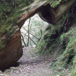
There are many sacred trees along the way from the sacred tree area of Lalashan to the Guishan Police Post, and there are also many huge fallen trees. Since large fallen trees are not easy to be removed, it is often seen that the giant trees lying on the road are sawn open to form a passage. The huge fallen log in this image is located near 15K of the trail.
Natural Scenic Sight
Gigantic Fallen Tree
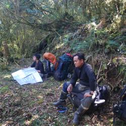
Sacred Tree
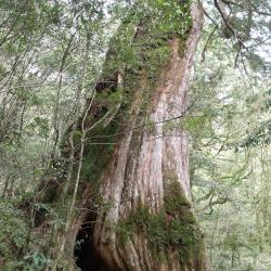
There are many sacred trees scattered along the trail between Lalashan and Guishan Police Post, as well as the Lalashan sacred trees at the Baling Mountaineering Entrance.
The altitude of this area is between 1,300 and 1,700 meters, and the climate is suitable for the growth of cypress forests. The sacred tree in the image is located between the Guishan Police Post and the Lalashan Police Post.
Yinu Falls
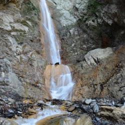
The Yinu Falls is located in Xinyi Township, Nantou County, with an altitude of about 1,750 meters. It is about 6.3 kilometers from the Dongpu Mountain entrance to the falls. The roads are often collapsed, so you can choose to go the detour route behind Lele Mountain Hut. The Yinu Falls is about 4 kilometers away from Duiguan police post.
The formation of Yinu Falls is due to the different degrees of resistance to weathering of each geological and lithological property, resulting in differential erosions. Similar to Yunlong Falls that hangs off the cliff wall, the Yinu falls is divided into several sections and winds down into Chenyoulan River. Yinu, or Otome in Japanese means girl in Japanese. It was given this name because the water falls gently and gracefully like a girl.
Yunlong Falls
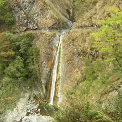
The Yunlong Falls is located in Xingyi Township, Nantou County, and is a tributary of Chengyoulan River and the upper stream of Lakulaku River. At an altitude of about 1,640 meters, it belongs to the Zhuoshui River Basin. The waterfall hangs on the rock wall next to the Batongguan historic trail, making it the most spectacular waterfall on the trail.
Coming from Dongpu you will pass the Fu-tzu cliff or the cliff of "Father Does Not Know Son". Due to the dangerous terrain and falling rocks, even when the father travels with the son together, they will not be able to take care of each other, hence the name.
Historic Trail near Mahouwanshan
The eastern section of Guanmen Historic Trail starts from Bazai Village to the ridge of Bazai Mountain, bypasses Xinglujun Mountain and Mahouwanshan, then goes up along the southeast ridge of Luntaiwen Mountain, After bypassing the top of Luntaiwen Mountain, it then descends steeply to Matai’an River, and then climb from the bottom of Matai'an River to the south three-section ridge line. Head north for another one kilometer you will reach the Guanmen Pond at the foot of Guanmen Mountain.
Matai’an River
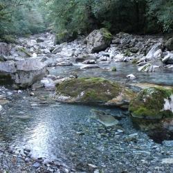
Mataian River originates from the north of Danda Mountain and is one of the tributaries of Hualien River. After the Guanmen Historic Trail crosses the highest point in the eastern section of the Luntaiwen Mountain, it first descends along the ridge to the west saddle of Luntaiwen, then goes down around two big ravines, and then descends along the northwest ridge to the upper reaches of Matai’an River at an altitude of 1,800 meters. On the lower stream, there is a wide flat land, where the camp of Qing army was stationed. There are seven red cypress trees that are more than 15 meters tall and so it was called "Giant Tree Camp Site". The stream there is crystal-clear, knee-deep, and there are white boulders everywhere with lush forests on both sides of the stream, making it very peaceful.
Bazaishan
Bazaishan is located in Wanrong Township, Hualien County, above the Fuyuan National Forest Recreation Area, at an altitude of 1,755 meters. It is the first mountain to reach from the east section of Guanmen Historic Trail.
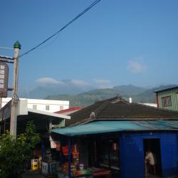
Looking west from Fuyuan Railway Station in the early morning, you can clearly see Bazaishan, which is the mountain top in the mist on the left side in the photo. However, it is usually cloudy and covered in the afternoon. Bazaishan is rich in ecology. The Fuyuan Forest Recreation Area at the foot of the mountain is a well-known place for viewing butterflies. Especially from March to August every year, you can see more than 30 kinds of butterflies such as the common bluebottle, hebomoia glaucippe formosana, and minois dryas.
Junjianyan (Warship Rock)
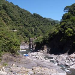
Where Taigang and Baishi River join is called Yufeng River. After crossing Xiuluan, you can see a huge rock on the other side of the river that looks like a sailing warship protruding from Yufeng River. During the Japanese rule, there was a suspension bridge that led to Zhishengmaotai Mountain on the opposite bank. The bridge was demolished in the 1970s because it was unsafe for crossing. In addition to the Xiuluan Hot Spring below the Xiuluan hamlet, you can also see bubbling river surface below the Junjianyan (Warship Rock), were hot spring gushes out from the rock crevices. It is the outcrop of Junjianyan Natural Hot Spring, a carbonated spring with a water temperature of about 50 degrees celcius. It is suitable for bathing when the temperature is adjusted through mixing stream water and hot springs. Tourists often camp near Warship Rock during holidays.
Shitiping
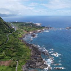
Shitiping is located on the coastal reef area on the south side of Shiti Port in Fengbin Township, Hualien County. The traditional name is Tilaan, which means a place to stay overnight. Before the provincial highway 11 was established, people heading north to Maogong had to travel on foot and on return, they needed to stay overnight in this place. During the Qing period, when the commander-in-chief Wu Guangliang led his troops here to open the road, he saw the stair-like formation of the rocks and named the place Shitiping (Rock Stairs). Over the past 100 years, the Kavalan, Amis, and Han people have successively moved to the vast land at the foot of the mountain on the east side of Shitiping. By the 1990s, the natural sea-eroded reef landscape of Shitiping had become a famous tourist attraction.