能高越

Xibao
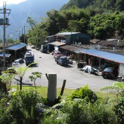
西寶國小旁的西寶聚落一景。

Xibao is located 161 kilometers away from the Zhongheng Highway. It is a large river terrace. Anthropologists have discovered pottery and stone spinning wheels on the Xibao terrace, which may have been left by humans in the late Neolithic period. About 250 to 300 years ago, after the Truku people settled in the Liwu River valley, they established the Xibao community here. After the Japanese implemented the Lifan policy in 1915, they were forced to move away. After World War II, some returned to the tribe. When the Zhongheng highway began to be excavated, vegetables and fruits were grown on the terraces of Xibao River due to the inconvenient transportation of vegetables in mountainous areas, and Xibao Farm was established. After the highway was opened, the Retirement Association arranged for the veterans to settle here. There is Xibao Elementary School on the terrace. It was originally a school for the children of the Xibao Farm workers, and later it was changed to Forest Primary School. It is the only forest primary school in the country and the only primary school inside the national park.
 

Walking Trail on the Main Peak of Hehuan Mountain
日治時期,日本政府為討伐太魯閣族人,曾先後組成探險隊進行五次的地形探勘,當時的台灣總督佐久間左馬太曾於大正元年(1912)9月底,隨合歡山探險隊登上合歡主峰山頂,親自觀測周圍的地形環境。現在在合歡山主峰山腰,公路的上方,隱約可見一條與公路平行的小路,這就是太魯閣戰役時日軍所開出的軍用道路,路跡仍清晰,可走上一小段,體會一下日軍當年的討伐之路。

The main peak of Hehuan Mountain is 3,417 meters above sea level, which is the watershed between Liwu River and Zhuoshui River. The mountaineering entry is located at 30.8 km from Taiwan Provincial Highway 14. Since a radar station was built on the Hehuan Main Peak in the early years, the Hehuan Main Peak Trail is actually a road for military vehicles. After the troops withdrew in 2000, the National Park  reorganized this area and transformed old foundations (other than telecommunication base station) into a viewing platform. From the top of the mountain you can see Hehuan Peak, Qilai Peak, Nenggao Mountain, Nanhu Mountain, Central Sharp Mountain, and Yushan Mountain at a glance.

Wugang Shrine
)霧ケ岡社入口的鳥居,霧ケ岡社戰後被拆除,入口的鳥居上方短柱也是戰後被加上去的。

The Wugang Shrine ruins is located in Jiesho Lane next to the Wushe fire station. Enter the alley and walk for about one or two minutes you will see a red torii gate and stone steps leading to Delong Temple. This torii is the remains of Wugang Shrine. On both sides of the stone-steps there is an abandoned stone lantern, also left from Wugang Shrine. The opening of Wugang Shrine was on December 16, Showa 7 (1932), and the ritual day is October 28th each year. After the war, the shrine was changed to offer sacrifices to Kaitai Shengwang and Fude Zhengshen. In 1958, the government promoted Confucian education and renamed it "Confucius Temple". In 1960, it was renamed "Delong Temple". From the square in front of Delong Temple, you can overlook Wushe Street and Wanda Reservoir. 

Wushe
從空中俯瞰霧社

Wushe, located in Ren'ai Township, Nantou County, sits above the terrace on the west bank of the upper Meixi creek at an altitude of 1,148 meters. It is the intersection of three historic trails: Nenggao Traversing Historic Trail, Hehuan Traversing Historic Trail and Pyanan Historic Trail. It is also the hub of the Aiyong Boundary and has been vigorously constructed by the Governor-General in Taiwan, with administrative agencies, trade companies, hotels, and so on.

In the past, Wushe was not inhabited locally. The Zhuo group of the Bunun tribe called it Ish-Tibuo, which means the northern tribe. During the Qing period, the Han people used Hoklo language to transliterate it to Zhiwushe. Later, it got referred to as Wushe. In the post-war period, the National Government established the township office on Yingtai next to Wushe main street. Today, the residents are mostly Han Chinese.