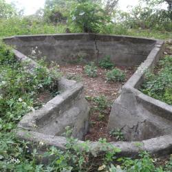
Old Laiyi is located on the mountainside on the left bank of the upper reaches of Neishe River at an altitude of about 360-600 meters, forming two hamlets. The large hamlet in the southeast is called chajiakavus, while the smaller hamlet in the northwest is called chingasan (translated as Zhenya community), which was separated from the larger hamlet. At that time, it was under the jurisdiction of the police post stationed there.
Slate House
Water sink next to the Old Laiyi Police Post
Old Laiyi is located on the mountainside on the left bank of the upper reaches of Neishe River at an altitude of about 360-600 meters, forming two hamlets. The large hamlet in the southeast is called chajiakavus, while the smaller hamlet in the northwest is called chingasan (translated as Zhenya community), which was separated from the larger hamlet. At that time, it was under the jurisdiction of the police post stationed there.
Bazaishan Water Source
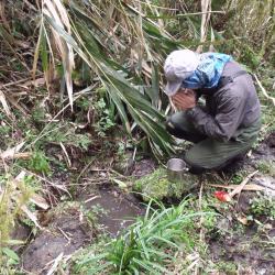
The water source of Bazaishan is located between Bazaishan and Xinglujun mountain. It is about 1,800 meters above sea level on the ridge line. It emerges directly from the ground. It is one of the very important water sources on the eastern section of the Guanmen Historic Trail. Starting from the industrial road at the foot of Bazaishan, it takes about a day on foot to reach this spring. There are no other water sources on the way, therefore, this water source is particularly precious. The Bunun people believe that the spring is bestowed by the ancestors, so when they use the spring water, they will thank the ancestors first, pray and worship beside the spring.
Slate Houses of Old Gulou
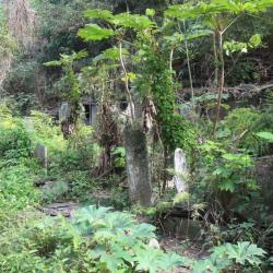
The Old Gulou Hamlet is located on a steep slope, on the south-eastern side of Mount Wuwei in Laiyi Township, Pingtung County. It is at an altitude of about 1,150 meters. The traditional Paiwan name for the place is Kuljaljau, though it is also known as Kulun’ao and Jalongya.
During the Japanese occupation, the hamlet was the largest indigenous settlement. There were five close-knit tribes, among which Umaq was the first to be developed, and the others were derived from this. At the end of the Japanese occupation, as Old Gulou Hamlet centered on the Kunanau Police Post at that time, the Government-General in Taiwan encouraged the tribes to move to Taimali Township and Daren Township in Taitung County in order to divide the tribe.
In the early post-war period, the National Government also arranged a collective relocation of the hamlet to the current Gulou Hamlet.
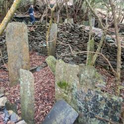
Tomb of the fallen warriors
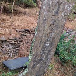
Located in Laiyi Township, Pingtung County, there is a tombstone at the entrance of the old Gulou Hamlet, which is engraved with the words “Tomb of warriors who died in the battle”. It was the tragic death of those indigenous peoples who joined the Takasago Volunteer Team and fought in the Pacific War that occurred at the end of the Japanese Occupation period. The rectangular tomb covered with stone slabs is a joint burial site for these men.
During the Second World War, Taiwan’s Government-General organized a group of young indigenous peoples to assist in the war in Nanyang. This organization, commonly known as the Takasago Volunteer Team, was dispatched several times. In 1942, the first batch of 500 Takasago volunteers came forward to serve the country. They went to the Philippines to fight, and later were even reorganized into the special task force.
Historic Trail on the northern side of Kashan
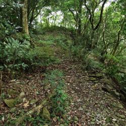
Kashan is located in Laiyi Township, Pingtung County, on the north side of the mountain, at about 1,250 meters above sea level. Kashan has a section of the Kunlun’ao Trail, which was the first road excavated to manage indigene in the Qing period. During the Japanese occupation, the Government-General in Taiwan used part of the Kunlun’ao Trail as a Lifan road (indigene management route), starting from Chaozhou in the west, passing through Laiyshe, and arriving at the Guloushe. From the east, the trail goes from Jinlunshe, passing by the Huangshe and reaching the Zhuyegeshe. The middle section that crosses the central mountain range is left unused.
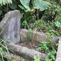
Abandoned Slate Houses in Old Laiyi Hamlet
The old Laiyi hamlet, in Laiyi Township, Pingtung County, is located on the mountainside on the left bank of the upper reaches of Neishe River. It is about 360 to 600 meters above sea level. There are two hamlets. The larger one on the southeastern side is called Chajiakavus. The smaller one on the northwestern side is called Chingasan, which stemmed out from the larger hamlet. In fact, during the Japanese occupation, the Government-General in Taiwan set up a police post in Laiyishe. In the early post-war period, the tribes were forced to collectively relocate their villages to the present Laiyi hamlet.
To get to Old Laiyi hamlet, enter from the fork road on the 6.5 km point of Yilin Road, and you will see the stone stele of the old Jala’afus tribe at the entrance. There are still large-scale slate houses in the hamlet ruins.
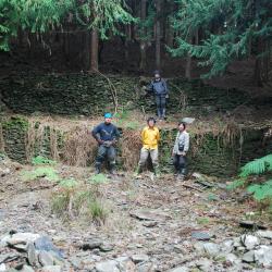
Stone steps in Bazai Mountain
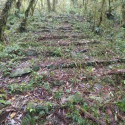
The stone steps in Bazaishan are located in Ruisui Township, Hualien County.
Bazaishan is the first mountain on the eastern section of the Guanmen Historic Trail. The entrance to the trail is in the Fuyuan National Forest Recreation Area. Enter from the industrial road outside the Butterfly Valley, go through the old afforestation path to reach Nasida Hamlet, and the stone steps are on the road to the hamlet.
Due to the steepness, there are many stone steps along the way, especially on the road close to the forest triangle point, where the stone steps are very dense. Road closer to Nashida Hamlet is gentle and therefore, has less stone steps.
Marshland in the east section of Guanmen Historic Trail
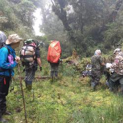
The Guanmen Historic Trail, which straddles Jiji Township of Nantou County and Ruisui Township of Hualien County, began construction in 1886 and completed in the following year. The trail starts from Jiji in the west and reaches Fuyuan in the east, about 105 km in length. It was the last excavated road during the Qing period but was not frequently used by the officials then.
During the Japanese occupation, the trail was used by the Government-General in Taiwan to force the Kashe group and Danshe group of the Bunun tribe to move to a concentrated village.
Nowadays, there is a marshland in the east section of the Guanmen Historic Trail, which is located below the ridge line of Bazaishan. Due to the humid and rainy climate here, many sections of the road are quite muddy. Although the terrain is wide, flat and covered with short grass, the bottom is full of mud and is easy to sink in when walking on it.
Slate house in Haba'ang Hamlet
Haba’ang Hamlet is located on the right bank of the Haba’ang River in the upper reaches of the east Danda River in Xinyi Township, Nantou County. It is about 1,600 meters above sea level, at the end of the ridge line extending from the west edge of Mount Guanmen. It belongs to the Danshe group of the Bunun tribe.
During the Japanese Occupation period, influenza occurred, leading to the death of many tribal people.
Today, due to the afforestation by the Forestry Bureau, there is almost no weed growing there. In addition, due to the remote location and little traffic, the ruins have been well-preserved. There are about 10 slate houses scattered on a wide platform. The neatly stacked stone walls and earthen pots are located by the door of many houses. Unfortunately, many of them have been damaged.