
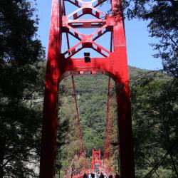
The Balong Suspension Bridge on the Jiaobanshan Sanxing Historic Trail from the Japanese occupation period is located 47 kilometer away from today's Northern Cross-island Highway, next to the Baling Scenic Bridge. The predecessor of the Northern Cross-island Highway was the Jiaobanshan Sanxing Historic Trail during the Japanese occupation. In October of Taisho 3rd year (1914) the Japanese built the Balong Suspension Bridge. When the Northern Cross-island Highway was built in the 1960s, the Bridge was demolished and rebuilt into the Baling Bridge. Although the suspension bridge no longer exists, the Taoyuan City Government has reproduced a small section of the suspension bridge at the southern end of the bridge, allowing tourists to see the full image of the bridge at that time.
Suspension Bridge
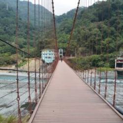
Baling Bridge is located 47 kilometers away from the Northern Corss-island Highway. The predecessor of the highway was Jiaobanshan Sanxing Historic Trail during the Japanese occupation, and in October of Taisho 3rd year (1914) the Japanese built the Balong Suspension Bridge. When the Northern Cross-island Highway was built in the 1960s, the suspension bridge was demolished and rebuilt into the Baling Bridge. Since the Cross-island Highway leads to Jiaobanshan, Lalashan, Qilan, Mingchi and other important tourist and recreational areas, the traffic volume surges every holiday. The original Baling Bridge width is only 4.6 meters, the width of the road is insufficient, and it is easy to cause traffic jams. The new Baling Bridge was built to solve the problem of traffic congestion and was opened to traffic on July 30, 2005. The old Baling Bridge was changed to a pedestrian-only scenic bridge. The tunnel No.1 and No.2 on both ends of the bridge were also transformed into an Atayal Cultural Exhibit Hall.
This suspension bridge that leads to the Baileng Police Post can be seen from the 1/50,000th topographic map of the Japanese rule during the Showa period. The bridge was the predecessor of the monitoring route of Baileng Aiyong Border, which was excavated on February 23, Meiji 44 (1911). The route began from the Beileng Supervision Office, going up the Dajia River and arriving at the シウワンタイム, with a total length of about 4 miles (about 16 kilometers). In the 3rd year of Taisho (1914), because the original old defile was very narrow, Taichung Office planned to widen the road from Dongshijiao to Baxianshan to facilitate the logging business. It was finally excavated by the Forestry Bureau of the Governor's Office of Taiwan, but the road still ended in Jiurai (now Songhe, Heping District, Taichung City).
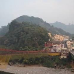
The image of a new community, Fuxing village, was taken from Tianleng. The path on the left side of the settlement is the forest railway that was used in the former Basianshan Forest Farm, leading to Basianshan.
Baxianshan Forest Farm was one of the three major forest farms in Taiwan during the Japanese occupation. The logging of the forests began in November of the 4th year of Taisho (1915). In the 5th year of Taisho (1916), the Forestry Bureau of the Taiwan Governor set up a Basianshan branch office in Jiabaotai that ministered to various businesses. Afterward, after various transfers, in Showa 17 (1942), Taiwan Takushu Co., Ltd. was transferred to become a government-business joint venture. After the war, the logging business continued in this field, and the production volume exceeded the sum of the Japanese occupation period by the mid-1950s. In 1963, the forest farm stopped production. At present, Basianshan is under the Dongshi Forest Area Management Office of the Forestry Bureau.
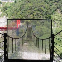
This is a simulation diagram of the Balong Suspesion Bridge, which is located at the southern end of the bridge. It is accessible through the Baling Scenic Bridge that is located at 47 kilometers away from the Northern Cross-island Highway. The predecessor of the Cross-island Highway was the Jiaobanshan Sanxing Historic Trail during the Japanese occupation. In October of Taisho 3rd year (1914) the Japanese built the Balong Suspension Bridge. When the Northern Cross-island Highway was built in the 1960s, the Bridge was demolished and rebuilt into the Baling Bridge. Although the suspension bridge no longer exists, the Taoyuan City Government has reproduced a small section of the suspension bridge at the southern end of the bridge, and set up a simulation diagram there, allowing tourists to see the full image of the bridge at that time.
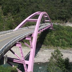
The Baling Bridge, which spans across the Dahan River, was completed in 2005 and is an important landmark in the Baling area. In the 3rd year of Taisho (1914), the Japanese built the Baling Suspension Bridge here. When the Northern Cross-island Highway was built in the 1960s, the suspension bridge was demolished and rebuilt into the Baling Bridge. Since the Cross-island Highway leads to Jiaobanshan, Lalashan, Qilan, Mingchi and other important tourist and recreational areas, the traffic volume surges every holiday. The original Baling Bridge width is only 4.6 meters, the width of the road is insufficient, and it is easy to cause traffic jams. The new Baling Bridge was built to solve the problem of traffic congestion. After the new Baling Bridge was opened in 2005, the old Baling Bridge was changed to a pedestrian-only landscape bridge.
The Baishi Suspension Bridge was first built in the 10th year of Taisho (1921) and rebuilt in 1947. The bridge is about 145 meters long and 90 centimeters wide, crossing the main stream of Sakyacin Creek. Skayacin means white stone (Baishi) in the Atayal language. Sakyacin Creek originates from the west side of the north edge of Dabajian Mountain, and is one of the two major tributaries of the upper reaches of Dahan River. In recent years, due to the increase in the number of tourists, it has been renovated again in consideration of safety, and an explanatory board is set up beside the bridge.
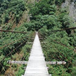
Qingquan No. 1 Suspension Bridge is located in Qingquan Hamlet, Taoshan Village, Wufeng Township, Hsinchu County. It is about 535 meters above sea level and crosses Shangping River. Qingquan No. 1 Suspension Bridge also connects to Qingquan Police Station. It is about 157 meters long, 25 meters high, and 1.4 meters wide, and is the highest suspension bridge in the Qingquan area. You can overlook the entire Qingquan area from the bridge. Where the bridge is standing was the original site for the Inoue Railway Bridge during Japanese rule. Both ends of the bridge still have sections of the Syakaro guard road remaining from those time. The Railway Bridge was damaged due to disrepair for a long period of time and in 1996 the current bridge was rebuilt on the same site.
The Guzilun suspension bridge is erected on the Chachayadun River, and was one of the important suspension bridges on the Jingshuiying Trail. The bridge was erected in the 6th year of Taisho (1917). At that time, the Guzilun police post was located on the north bank of the Xidi camp site (Miaopu) of the Qing Dynasty, so the suspension bridge was called the Guzilun Bridge. In the 7th and 8th years of Taisho (1918 and 1919), the suspension bridge was damaged twice by typhoons. In the 14th year of Taisho (1925), the suspension bridge was re-erected. The remnants of the suspension bridge seen today were rebuilt in the 15th year of Taisho (1926). Today, only the cement bridge girder remains intact. Around the bridge girder, the iron wires used for the suspension bridge at that time can still be found. On the bridge girder, there are engravings of the words “Completed in March 15th year of Taiso”.
The Balong Suspension Bridge in the Fuxing District of Taoyuan City is located on the 47 km point of the Provincial Highway 7 and was completed in 1914. It was the junction of the Fuba Historic Trail and the Jiaobanshan Sanxing Guard Road during the Japanese occupation. The Sanxing Guard Road is the predecessor of the current Northern Cross-Island Highway.
In the post-war period, the National Government built the Northern Cross-Island Highway, demolished the Balong Bridge and built the (old) Baling Bridge.
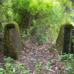
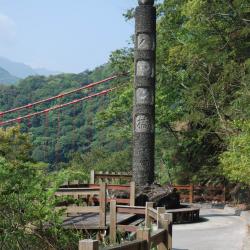
Today, in the small park next to the tunnel entrance, the memorial stone pillar of the Balong Bridge still stands, with “Balong Bridge” carved on the front, and the year it was built engraved on the back. Later, due to traffic congestion, the Ministry of Transport built a new Baling Bridge at the lower reaches of the Baling Bridge.