Road Excavation and Indigene Management

Fenggang
從台26線省道遠眺楓港聚落

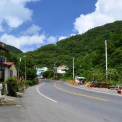
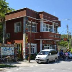
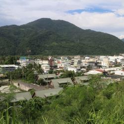
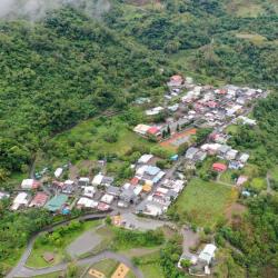
Fenggang is located on the south bank of the Fenggang River near the shore in Fangshan Township, Pingtung County. As it is located in the month of Fenggang River, it was named after the strong downhill wind in winter. In the past, Fenggang was the junction where indigenous peoples and Han Chinese traded.  It was the traditional territory of the Paiwan from Shebulishe. It was also the starting point of Fenggang Beinan Historic Trail when it was excavated during the Qing period. During the Japanese occupation period, the Governor-General in Taiwan set up a police post to monitor the operation between people from the mountains and people from the plains, and to manage the security of the Fenggang area. Today, the Fenggang Police Post is transferred into a Biker Rest Stop for cyclists and tourists.


Caopu Hamlet
草埔部落街景

The Caopu Hamlet is located in the upper reaches of Fenggang River in Shizi Township, Pingtung County.  It was formed by the migration of residents from Caopuhoushe and Qulieyoushe at the end of the Japanese occupation. Due to the limited flat living space, the houses dispersed everywhere, divided into Upper and Lower Caopu. The current Caopu Elementary School was moved from Caopuhoushe to its current location in 1940.

Shouqia
位在屏東縣獅子鄉的壽卡派出所和鐵馬驛站

Shouqia is located at a small mountain pass at the end of the Central Mountain Range, about 500 meters above sea level, at the junction of Shizi Township in Pingtung County and Daren Township in Taitung County. Not only is it located on the Fenggang Beinan Historic Trail,  it is also where the Nanhui Road passes through today. In fact, Fenggang Beinan Historic Trail was built under the policy of excavating mountains to manage indigenes during the Qing period. The excavation mainly went along the river heading north-east from Fenggang. It does not overlap with Nanhui Road but runs alongside the tribal passage all the way to Shouqia. Finally, arriving at Dawu from Rumulu River.


Jinlun Hamlet
從高處遠眺金崙部落

Jinlun Hamlet is located on the alluvial plain on the north bank of the Jinlun River estuary in Taimali Township, Taitung County. The traditional Paiwan name for the place is Kanaron, which was named after the abundant rosary pea plants there. It can also be called Hanzilun or Jiazinan. Jinlun hamlet existed as early as the Dutch colonial period, and once participated in the Eastern Local Conference held in Beinan in 1655. Due to its ideal location at the mouth of Jinlun River, it was an important place to dispatch coastal defense troops to garrison during the Qing period. During the Japanese occupation, police post, education center, and trade center were also set up there.


Liqiu Hamlet
從空中俯瞰歷坵部落

Liqiu Hamlet, located in Jinfeng Township, Taitung County, was formed by the amalgamation of three settlements: Rulakes’she, Chushuiposhe, and Jiajiaduowanshe. At the end of the Japanese occupation, the Government-General in Taiwan enforced a collective migration into Rulakes’she. After the war, the National Government re-named the hamlet to Liqiu, which became the largest hamlet in Jinfeng Township.


Slate House Ruins in Zhuyege Hamlet
諸野葛社倒塌家屋內的祖靈柱,前方擺有祭品

Zhuyege Hamlet is located in Jinfeng Township, Taitung County. The hamlet sits on the gentle slope of the Dalili Mountain ridge, about 525 meters above sea level. At the end of the Qing period, due to the farming of the land in the Zhuyegeshe, some of the tribesmen moved to the southern side on the right bank of Nabao River and built a new hamlet near Huangshe. Later, the tribesmen migrated away from the hamlet and formed Daoweilaoshe and Nabaoshe. In the early days of Japanese rule, the tribes of Zhuyegeshe moved to the vicinity of Huangshe. In the early post-war period, the National Government moved all the tribesmen near Huangshe to the mountain reservation land in Beili Village, Taimali Township. The hamlet was rebuilt and its name was changed to Xinxing Village.

Neipu Camp
清領時期內埔大營的所在位置

Neipu Camp, located in Neipu Township in Pingtung County, was the base camp for the excavation of the Kunlun’ao Trail during the Qing Dynasty period. It has now been converted into a local cemetery. After the Mudanshe incident in 1874, the Qing government began to actively govern Taiwan and formulated a policy of excavating mountains and managing indigenes. The most important measure was to build the garrison road that connected the front and the back of the mountains. The first to be excavated was the Chishan-Beinan Historic Trail, also known as the Kunlun’ao Historic Trail. The trail was built in the same year as the Mudanshe incident. At that time, the two battalions were guarded by Zhang Kuiyuan, the town army, and troops were dispatched and stationed at camps of Kunlun'ao, Dashiyan, Audong and other camps to help Yuan Wenzhuo continue to excavate the trail.

Paotaishan (Fort Mountain)
砲臺山上清領時期的砲臺遺跡

Paotaishan (Fort Mountain) is located on the 105 km way of Provincial Highway 9 in the south in Su’ao Township, Yilan County, at an altitude of about 200 meters. It was built in 1884 when the Qing-French War broke out. The French army attacked Su’ao; and the Blue Cap commander Chen Hui-huang took advantage of the superior terrain of Paotaishan and carried cannons up the mountain with the help from local residents. The fortress and barracks were built there in consideration of the military fortress, and hence, the name “Paotaishan” (Fort Mountain) came about.

To this day, the six hundred-strand front chamber cast iron guns are stored in the warehouse of the Su’ao Township Office.

Kotohira Shrine
金刀比羅神社的社號碑

The Kotohira Shrine, located in Su’ao Township in Yilan County, was built in 1927 by Shinto shrines carpenters, who arrived in Taiwan during the Japanese occupation. The shrine was for worshiping General Kimpira, one of the 12 Buddhist saints, who is the guardian of sea traffic. Therefore, shrines like Kotohira Shrine are mostly built by ports. 


Today, the main building of the Kotohira Shrine no longer exists. Although the foundation and path of the shrine can still be seen with stone benches, stone tables, stone lamps, and stone pillars, and that the overall spatial pattern is still roughly complete, the stone steps below the first level foundation were demolished during the construction of the Suhua Highway. In 2010, the Yilan County Government announced it as the county’s heritage site.


Nan’ao Shrine
南澳祠遺址

Nan'ao Shrine, located in Nan'ao Township in Yilan County, was founded in 1936. The Atayal people call the place “Kinan”, meaning a very beautiful environment.  The name, Nan’ao, first appeared in historical documents in 1810. It was called Da Nan’ao because it was located in the south of Su’ao. It was only renamed to Nan’ao during the Japanese pccupation period. After the establishment of the Nan’ao community in 1932, this name got widely accepted by everyone.