Police Station

Dashuiku Police Post
大水窟駐在所的石牆與大水窟山屋的木構建材,遺址有引水鐵管

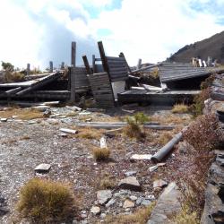
The Dashuiku Police Post is located on the flat shoulder on the east side of Mount Nandashuiku, at an altitude of 3,150 meters.  It was established in 1920 and was the highest police post on the Batongguan Traversing Historic Trail during the Japanese occupation. November to April is the period when the mountains are covered with snow. Therefore, life at the Dashuiku Police Post faced various difficulties, such as the sudden temperature drop that caused the drinking water to freeze and daily water needed to be collected from Maiasang Police Post, which is several kilometers away. There were even times when all staff needed to be evacuated to Maiasang Police Post due to freezing weather. In the 1980s, the Yushan National Park Management Office built the Dashuiku mountain hut next to the former site of Dashuiku Police Post, but it was destroyed by a typhoon in 1999.


Platform of Old Laiyi Police Post
舊來義石板屋群上方的寬闊平臺,即為駐在所遺址

The Old Laiyi Police Post is located on a wide platform above the slate houses of the Old Laiyi tribe in Laiyi Township, Pingtung County. There are relics such as iron houses, water towers, and water tanks on site. The building was set up by the Government-General in Taiwan during the Japanese occupation. In fact, there are two hamlets in the area.  The larger hamlet on the southeastern side is called Chajiakavus, and the smaller hamlet on the northwestern side is called Chingasan. In the early post-war period, the tribesmen were forced to collectively relocate their villages to the current Laiyi hamlet.

To get to Old Laiyi hamlet, enter from the fork road on the 6.5 km point of Yilin Road, and you will see the stone stele of the old Jala’afus tribe at the entrance. There are still large-scale slate houses in the hamlet ruins.

Zhongzhiguan Police Post
中之關駐在所的解說石亭,內有解說牌

The Zhongzhiguan Police Post is located in the Taoyuan District of Kaohsiung City. It is an extremely important stop on the Guanshan Historic Trail because it overlooks Yusuishe from there, and monitors the then Bunun chief, Lahu·Ali, who lived opposite Zhongzhiguan, on the upper reaches of the Lunong River. Lahu·Ali, who has fought continuously against the Japanese for 20 years, once visited the Zhongzhiguan Police Post twice and came to a peaceful settlement there. In fact, the Zhongzhiguan Police Post had a huge establishment, and the police department with the highest rank was stationed here for a long time.

Today, the historic trail section between Tianchi and Zhongzhiguan is made into hiking trails by the Yushan National Park. There are also tourist rest stops and information boards at the ruins of the Zhongzhiguan Police Post.


Xuejian Police Post
調查人員於雪見駐在所的臺地前方合影

The Erbensong Visitor Center is located in Tai'an Township, Miaoli County. The building was initially a police post, built in 1911 by the Government-General in Taiwan, to monitor the northern group of Atayal tribe in the Da’an River basin. Erbensong in Japanese refers to a place with two pine trees. The traditional Atayal name of the place is Pihun, which means gate.

During the Japanese occupation, the police post was subjected to fierce attacks by the Atayal. In the post-war period, the National Government changed the names to Erbensong Police Station and Song'an Police Station. When the Jiji earthquake occurred in 1999, police officers were relocated to Meiyuan Police Station. Hence, the building has now been converted into Erbensong Visitor Center to provide visitors with environmental education service and tourist information.

Erbensong Visitor Centre
二本松解說站的丸田砲臺文史紀念館

The Erbensong Visitor Center is located in Tai'an Township, Miaoli County. The building was initially a police post, built in 1911 by the Government-General in Taiwan, to monitor the northern group of Atayal tribe in the Da’an River basin. Erbensong in Japanese refers to a place with two pine trees. The traditional Atayal name of the place is Pihun, which means gate.

During the Japanese occupation, the police post was subjected to fierce attacks by the Atayal. In the post-war period, the National Government changed the names to Erbensong Police Station and Song'an Police Station. When the Jiji earthquake occurred in 1999, police officers were relocated to Meiyuan Police Station. Hence, the building has now been converted into Erbensong Visitor Center to provide visitors with environmental education service and tourist information.

Erbengsong Trench Ruins
二本松駐在所通往丸田砲臺的古道路段

The Erbensong trench ruins in Tai'an Township of Miaoli County is located on the river terrace platform on the southern slope of the Erbensong Police Post, about 1,350 meters above sea level. It was designed to facilitate the Wantian Battery in combat and to prevent from indigenes attacks. There is a piled stone road built next to the Erbensong trench, which is the road that connected Wantian Battery to Erbensong Police Post during the Japanese occupation. The road was mainly used for transporting grains and firearm supplies, so that the Government-General in Taiwan could monitor the northern Atayal group through the firepower of the battery.

Today, the remains of the trench are about 550 meters long, and the Sheipa National Park has renovated it into a hiking trail, surrounded by artificial forests.


Overlooking the saddle, the former site of Zhongjian Police Post
從茅草叢中遙望中間駐在所的鞍部

Zhongjian Police Post, in Tai’an Township of Miaoli County, is located at the northern foot of Mount Zheng, on the north-east side of Erbensong, and at an altitude of about 2,050 meters. It was built in 1923, between Mao’yili Police Post and Zheng Police Post. The origin of the name came from the last name of a police officer from the Hsinchu State Police Department.

During the Japanese occupation, there was afforestation of precious tree species such as cypress and formosan conifer. Today, the remains of the station are hard to find due to afforestation.

Quan Police Post
通往泉駐在所的入口處指標

Quan Police Post, in Tai’an Township of Miaoli County, is located at the south-east foot of the Luchang Dashan, on the north-east side of Erbensong, and at an altitude of about 1,800 meters. It was built in 1923 and subsequently abolished in 1927 because of the change in the area under surveillance by the guards. The original surveillance area was changed to the responsibility of Lushan Police Post and Zheng Police Post.

Today, to get to the Quan Police Post, enter from Guanwu on the Beikeng Creek Historic Trail, and at about 4.6km point of the trail you can see the entrance to the Quan Police Post.

Zheng Police Post
通往榛駐在所的入口處指標

Zheng Police Post, in Tai'an Township of Miaoli County, is located at the 2 km point on the west side of Mount Zheng, facing Mount Zheng across the Beikeng Valley. It is about 1,930 meters above sea level, and was built in 1924.

The origin of the name, Zheng, may be related to the forest of Asian Hazle that grow in the area. The traditional Atayal name for the place is Ginapan-papak. Papak means the ear, and Ginapan-papak means the shaved ear.

During the Japanese occupation, the guards stationed at Zheng Police Post and his family members set up charcoal kilns to burn charcoal to keep warm in cold winters. The remains of the charcoal kilns are still visible today.


Shu Police Post
曙駐在所下方的古道,道路地基的石砌駁坎整齊

Shu Police Post, in Tai'an Township of Miaoli County, is located at the northeastern foot of Beikeng Mountain, northeast of Erbensong, and at an altitude of about 1,730 meters. It was built in 1923.

The origin of the name, Shu (meaning dawn), is unknown but may be related to the landscape and the rising sun. However, the traditional Atayal name is Mai-leliuk, which means a place where many leliuk trees grow. Leliuk is a hard woody tree of the Fagaceae family. The tree trunk can be used as a hoe handle and ship beams. The fruits are often eaten by flying squirrels, muntjacs, squirrels, and black bears. Therefore, in the past, it was common to see black bears in this area.