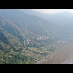
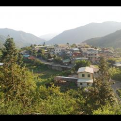
The Da'an hamlet belongs to Xiangbi Village, Tai'an Township, Miaoli County. It is located on the left bank of Da'an River, at the north foothills of Ma'an Mountain, on a platform about 500 meters above sea level. The residents of the Da'an hamlet are composed of residents from the Beishi Group and the Jialapai Group of the Atayal tribe. Residents from the Beishi Group are remaining survivors from rebelling against the Japanese in 1910, who were induced by the official government to move here. The Residents from the Jialapai Group were moved across the Da'an River after the Wushe incident.
Tayal
Da'an River Meixian Bridge
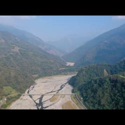
The bridge in the image is the Meixian Bridge that connects Meiyuan Village on the left and Xianbi Village on the right. It is about 700 meters above sea level and is at the junction of Taichung City and Miaoli County. The Da’an River Basin gradually forms a canyon from the upstream of Meixian Bridge, where the Xuejian Hot Spring is located at 18.5 kilometers upstream. Xuejian Hot Spring is on an altitude of about 1,020 meters, and the one-way journey takes about 9 hours. Xuejian Hot Spring a geothermal spring. The hot water and steam are in a high pressure state, and pass through the fissures of the stratum to the surface, forming the Xuejian Hot Spring.
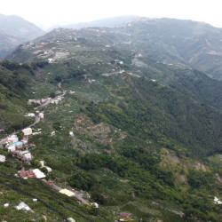
Meiyuan Hamlet
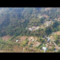
The Meiyuan hamlet is located in Meiyuan Village, on the right bank of Da’an River, at the southwest foothills of Jinwei Mountain, on a platform about 500 meters above sea level. The name of the tribe is Maylubung, which was named after the pool that draws drinking water for the tribe. Therefore, there is a pond on the land. The place is small and the terrain is low. After the war, due to the local planting of a large number of plum trees, the National Government named it Meiyuan (plum garden), which is the current name. In August 1963, Typhoon Geleri struck, and the flood washed away most of the tribe's farmland. Therefore, some tribes moved to settle in Heping Township of Taichung County, yet many people returned to settle here.
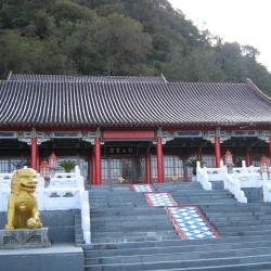
Guanwu Lodge
Maoyili (Japanese: Mogili) Police Post is located in the 8th alley of Meiyuan Village, Taian Township, Miaoli County. Mogili means a high hill in Atayal language. It was named Mogili because it is located at the junction of Miaoli and Wufeng Township, and it was a watershed with high terrain. In the 12th year of Taisho (1923), the Maoyili Police Post was established. After the war, the Forestry Bureau was engaged in logging and afforestation. Because it is located on the ridge line of the Luchang Mountain at an altitude of 2,200 meters, when the northeast monsoon comes in winter, it often leads to thick fog. Therefore, it was called Guanwu (viewing fog). Originally a state-owned forest land, the Forestry Bureau has set up a workstation, a guest house, a material transportation management station, and later set up a Guanwu National Forest Recreation Area. Since the site is located in the Sheipa National Park, it also has a National Park Visitor Center.
Tiangou Hamlet
The Tiangou hamlet is located in the 3rd to 6th alley of Meiyuan Village, Tai'an Township, Miaoli County, in the northeast of Da'an, and on the terrace on the right bank of the Da'an River. The Atayal people call it Saulau (or Vai-annuh, Mai-annuh), which means soil that can be dyed, sa means to dye, and ulau means land. It’s got the name because there are earth-colored, earth-yellow and red soils in the local area and were used as a source of dyeing pigments. It is also also called Vai-annuh, which means flat in the local Atayal language. The people originally lived in the Jinwei mountain area on the east side of the current location. During the Japanese occupation period, in the Taisho period, due to the implementation of the group relocation plan, they were moved to the current place to live. As the ridgeline looks like a crouchingdog and because of its high terrain, it was give the name, Tiangou. From the mid-1930s to 1937, some members of the Yehmagong comunity were moved to the Tiamgou settlement by the Japanese.
Lishan Hotel
Built in 1965, Lishan Hotel is located in the center of Lishan district. It was the earliest hotel built in the area, also one of the main hotels where President Chiang Kai-shek hosted foreign guests and stayed when he visited Taiwan. Designed by the same architect as Taipei Yuanshan and Kaohsiung Yuanshan, which are known as the three major palace hotels in Taiwan, the red exterior architectural features has become a landmark of Central Cross-island. The hotel began to operate in 1971 and was run by the National Military Retired Officers and Soldiers Guidance Committee of the Executive Yuan. It ceased operation after the 921 earthquake and Typhoon Minduli in 2000, and since it has not been maintained for more than a decade, it has lost its original glamour. In 2004, the hotel was taken over by the Shenshan National Scenic Management Offce, and was entrusted to be operated and managed by Lishan Hotel Co., Ltd. The hotel was rebuilt and reopened in December 2012.
Songmao Hamlet
The Songmao Hamlet is located 3 kilometers to the northeast of Lishan, on section four of Zhongxing Road, Lishanli, Heping District, Taichung City to be exact. It is located on the shoulder-shaped flat edge between Dajia River and its tributary Hehuan River, with an altitude of about 2,300 meters. During the Japanese occupation period, there was a Taibajiu police post in the area, so it was named "Taibaojiu"; Taibaojiu was also spelled "タボク" (Taboku) in Japanese, so the residents often referred to the community as "Tabok". After the war, the residents moved to the current site on the side of the road. The origin of the name Songmao is unknown, but it may be related to the variety of Songmao pear.
Xueshan
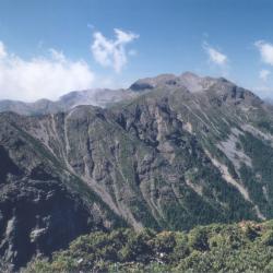
Xueshan is located at the junction of Heping District, Taichung City and Tai'an Township, Miaoli County. It is 3,886 meters above sea level and is the second highest peak in Taiwan. In July of the 4th year of Taisho (1915), Saitsu Kyuhei, the survey team of the Fan Affairs Bureau, and his party, crossed the southern saddle of Pyanan(now Siyuan Yakou) from the southern part of Beiyanshe (now Nanshan Village) to Zhijiayangshe (now Huanshan hamlet), followed by Zhijiayang Dashan ridgeline to complete the first ascent and measurement of the main peak of the snow-capped mountain. Since then, this route has become the most convenient way to climb the sub-alpine mountain (the name of Xueshan during the Japanese occupation). In the 4th year of the Showa era (1929), the governor of Taichung prefecture built the "Chigao Lodge" in the southeastern part of Xueshan, which was the only lodge in the area that accommodates hundred people. After the opening of the Xueshan Mountain Route in 1970, it replaced the Zhijiayang Line as the main route for climbing Xueshan because it was relatively gentle and easy to walk.
Central Cross-island Yilan Branch Project Monument
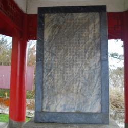
Inside the Siyuan Yakou pavilion, there is a "Central Cross-island Highway Yilan Branch Project Monument", which records the beginning and end of the road construction project. On the back of the stele, there are four words "Ying Shui Si Yuan" (meaning: drink water and remember the water source, be thankful) inscribed by General Zhou Zhirou, the then chairman of the Taiwan Provincial Government in August 1961. This is the origin of the place name "Siyuan Yakou". The Yilan branch line of Central Corss-island Highway began construction in January 1955 and completed in March 1959, with a total length of 111 kilometers. The predecessor of this road was the Pyanan Historic Trail during the Japanese rulw. In order to facilitate traffic and manage the indigines, the Japanese began to build the trail in the 7th year of Taisho (1918), which extended from today’s Leshui Village in Yilan County, passing through Mao'an, Siji, Nanshan, Siyuan Yakou in Taichung City, Huanshan, Lishan, Mailiguan in Nantou County, Marleba, Hongxiang, Ruiyan to Wushe, with a total length of about 120 kilometers. It was completed in the 10th year of Taisho (1921).
Pyanan Historic Trail
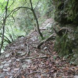
During the Japanese colonial period, in order to facilitate transportation and manage the indines, the Pyanan Historic Trail began to be built in March of the 7th year of Taisho (1918). The route goes through Huanshan, Lishan, Heping District, Taichung City, Cuiluan, Wangyang, Hongxiang, Ruiyan, and Wushe, Renai Township, Nantou County, with a total length of about 120 kilometers. It was completed in March 1921. This route was originally an aperture for the communication between the north and the south of the Atayal people. After excavation, it also became an important road for the "group migration" of the Atayal people. At present, this historic trail has been replaced by the Yilan branch line of the Central Cross-island Highway and the Lixing Industrial Road, leaving only two sections of the trail that do not overlap with the highway. One is the section from Yorkejiaoxi to Siyuan Yakou, and the other is from Lishan Anbu to Fushoushan farm.