Residential Police Box

Gulibabaunuo Police Post
調查人員以捲尺測量崖邊平臺的駐在所範圍

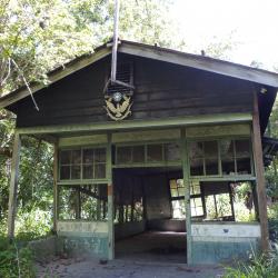
The Gulibabaonuo Police Post is located on the southeastern edge of Dahan Mountain, at an altitude of about 750 meters. It was set up in 1917 and was an important checkpoint for the Jinshuiying trail that led to the southern linking road. It is about 1.3 km away from the Chushuipuo Police Post. Due to the Jinshuiying incident in 1914, the trail was unusable for several years. The Governor-General in Taiwan sent personnel to investigate the status of indigenous peoples and restored the trail. At the same time, established the Dashulin and Gulibabaonuo Police Posts. Later in 1926, the Gulibabaonuo Police Post was abolished and a new one was re-established in Chachayadun Hamlet in the south.


Jingshuiying Police Post
調查人員於浸水營駐在所前的解說牌合影

According to Yang Nanjun, an expert on ancient road research in Taiwan, the place was called Jinshuiying (literally Soaking Camp) because of the fog all year round, abundant rainfall, and the terrain that is prone to accumulate water.  Before it got its name in 1894, the camp was called Dashulinying, which was set up during the Qing Dynasty period.   During the Japanese occupation, the Governor-General in Taiwan established the Jinshuiying Police Post in 1901 at an altitude of about 1,280 meters. It was an important base for government officials and business travelers traveling to and from the east and west.  However, the police post was destroyed during the 1914 Jinshuiying incident. After multiple rebuilding, it was withdrawn in 1936.


Sakayachin Police Post (Baishi Police Station)
木造瓦頂的白石派出所辦公廳

Sakayachin Police Post is located on the north side of Zuotengshan (Mount Sato) along the 2328 peak to the tail ridge in the northeast. It was established in 1922 and is about 1,630 meters above sea level. It was the most important stronghold on the Syakaro Historic Trail during the Japanese occupation, equipped with 30 guards. In the post-war period, the National Government changed its name to Baishi Police Station, and rebuilt the office dormitory in 1969. As a fact, the back door of the Baishi Police Station is the entrance to the road leading to Zuotengshan (Mount Sato). The road is not used nowadays and therefore, the Forestry Bureau put up warning signs to prevent hikers from entering by mistake.

Tianchuntai Police Post
調查人員於田村臺駐在所的正門口合影

Tianchuntai Police Post is located at the mountainside of 1998 peak and Mount Gaoqiao in Wufeng Township, Hsinchu County. It was established in 1922, and was named after the surname of the first police officer in charge, Tamura Yuichi (Tianchun Yongyi). The traditional Atayal name for the place is Tarofun. In the early days of the Japanese occupation, after two occurrences of the Syakaro incident, the Governor-General in Taiwan named this place Mukaraka Highland, and excavated the Luchang Lianling Road in 1925. Tiancuntai was the road’s starting point.

Today, Tianchuntai Police Post is located in the plantation area of Japanese Cedar. Due to the afforestation work, some sites of the police post have been destroyed. Only the gate ramps, stacked stone foundations and fort sites remain visible.

Zhuangzi Police Post
庄子駐在所後方高約1公尺的駁坎

Zhuangzi Police Post is located above the parking lot at the entrance of the present Syakaro National Trail, about 1,780 meters above sea level. After the construction of the Syakaro trail was completed during the Japanese colonial period, the Governor-General in Taiwan believed that this was an important strategic location. Therefore in 1922, the Zhuangzi Police Post was established with a foundation of more than 100 square meters. After a lapse of 2 years, it was removed because the area was considered quiet. 

Today, due to the widening of industrial roads and the excavation of the parking lot, the forecourt of Zhuangzi Police Post has collapsed. The remaining building structures that are still visible are rammed earthen walls, fort foundations, and stone ridges. 


Xiaolin Police Post
調查人員於小林駐在所的大門石階上合影

The Xiaolin Police Post, located on the first long ridge to the east of the Syakaro Police Post, was established in 1922, and named after the first Japanese supervisor’s surname. However, the police post was withdrawn after a lapse of 8 years. In order to cope with topographical changes, the foundation of Xiaolin police post is mainly L-shaped, with stone ridges built in the front and rear, which are still complete today.


Syakaro Police Post
シヤカロ-警察官吏駐在所的遺址現況

Syakaro Police Post is stationed on the south-facing long ridge, east side of Mount Mingdouyo, about 1,510 meters above sea level. Before the Syakaro Historic Trail was opened by the Governor-General in Taiwan during the Japanese occupation, the police post was the most penetrating official force in the mountain. In the early days of Japanese rule, the Governor-General set up the Syakaro Aiyong Supervision Office, and then in 1922 the Syakaro Police Post was set up with more than 20 guards. In the post-war period, the National Government changed its name to Shilu Police Station. 

To date, there are two parts of the former police post remaining on the site. The upper part remains the rammed earthen walls of the patrolling officer dormitory. The roof of the police post has collapsed and is unusable.

Songben Police Post
松本駐在所地基上的重建民宅

Songben Police Post is located on a convex ridge south-west of Mount Mingdouyo. It is about 1,360 meters above sea level and faces Atayal’s Rokkaho Hamlet (Lwax khu) of the Syakaro group across the stream. In the early days of the Japanese occupation, the Governor-General in Taiwan implemented a five-year (Lifan) indigenes management plan. The high-pressure governance measures caused dissatisfaction among the Atayal people and so in 1917, they fought with the Japanese which resulted in the Syakaro incident. Since it was an important strategic location, the Governor-General immediately set up a checkpoint in the following year. The Songben Police Post was then established in 1922, but was withdrawn after the people of Shishe of Syakaro group took refuge in the Beikeng River basin. To this day, the police post has been rebuilt into residential houses.