Ali

Attractions along Wutai Haocha Historic Trail

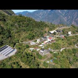
Ali settlement is located in the west corner of Ali Village, northeast of Kaligutsan (Mount Jingbu), west of Mount Yadini, on the left bank of Adel River, on a steeply sloping slope with an altitude of about 1200 meters. The Zhiben traversing trail from the Japanese occupation and today’s provincial highway 24 pass under the settlement, and is currently the settlement located on the highest point among the Paiwan and Rukai people. There are two settlements, Swabaliu and Swaumouman, north of Swabaliu.
 At present, the police station, elementary school, and village office are all located above the latter. Ali is Adel community, the Japanese call it shiyader, while in the Rukai language it is called Adithi, which refers to the people around the sharp fog-headed peaks.

  • - / -
  • - - -
  • -
  • - -/-
  • -
The building on the left in the image is the cemetery of the Ali settlement, and the settlement on the right is the Ali Swaumouman settlement. The tribal police station, elementary school and village offices are all concentrated here.
Ali Swaumouman Settlement
View of Ali Swabaliu Settlement from the top facing the south. It is clear that the buildings are built on the slope.
View of Ali Swabaliu Settlement from the top facing the west. The buildings are built on the slope.
古道地圖
沿途景點所在位置
沿途景點所在縣市
屏東縣
沿途景點所在鄉鎮
霧臺鄉