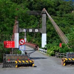
The Luming Bridge is located on the old Provincial Highway 9. It crosses Luye Creek, which flows from Taoyuan Village to Xiazhongli.
The bridge was designed by a Japanese architect in 1960 and is a steel cable suspension bridge constructed of steel cables and frames. The bridge deck is an asphalt road wide enough only for small vehicles to pass. Located on the right bank of the Luye River is Xiazhongli, which is called tashipalu in the Bunun language and means "the other side". During the Japanese occupation period, it was called Xiazhongli, which referred to the southeast of the current tribe. Compared with Shangzhongli in the upper reaches, it has been under the same jurisdiction as Wakagan (old Hongye) since the 14th year of Taisho (1925).
In addition to those who originally lived in the area, the Japanesecollectively migrated to Pasnanavan since Showa 6 (1931), and this place has also become one of the places to live. After the war, it was called Xiali for short.
- - / -
- - - -
- -
- -/-
- -

