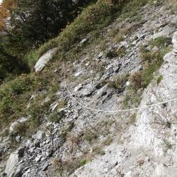
Collapsed section of eastern part of Neggao Traversing Historic Trail

Attractions along Nenggao Traversing Historic Trail

In the 6th year of Taisho (1917), the Japanese government opened up the Nenggao Traversing Trail and named it "Hatsune Qilai Crossroad", which is the old Nenggao Traversing Trail. In the 14th year of Taisho (1925), due to the high altitude of the eastern section of the old trail, snow often made it difficult to travel in winter, and the entire Traversging Trail of Hualien Harbor Hall and Nantou Hall was rebuilt, with a total mileage of 76.8 kilometers after completion.

   After the war, in order to restore the power system on the island of Taiwan, the Nationalist Government built a number of towers along the Nenggao Traversing route to complete the "East-West Link Transmission Line". In 1998, after the completion of the new east-west transmission line between Mingtan and Fenglin, the old east-west line was gradually replaced until it was officially decommissioned in 2016. At present, the west section of Nenggao Traversing Trail is well maintained due to the demand for the transportation of materials from Tianchi Lodge, and passing of locomotives. The eastern section, on the other hand, has a low utilization rate after the withdrawal of Taipower personnel, and the road conditions are not as good as the western section.


  • - / -
  • - - -
  • -
  • - -/-
  • -
A collapsed area between Upper Guilin Suspension Bridge and Guilin Tai-Power Hut. The path is narrow, is equipped with safety cable wire and allows only one person to pass.
50 minutes before reaching Guilin Tai-power hut is a river valley, where one can take a rest and collect water.
A collapsed area between Upper Guilin Suspension Bridge and Guilin Tai-Power Hut.
Trail along the montain wall near the Guilin Tai-power hut.
There are many giantic cypress trees on the eastern section of the Nenggao Traversing Trail, which is how the name Guilin (cypress) Tai-power Hut came about.
A water source that is 30 minutes away from Guilin Tai-power hut.
古道地圖
沿途景點所在位置
沿途景點所在縣市
花蓮縣
沿途景點所在鄉鎮
秀林鄉