Guanshan Historic Trail

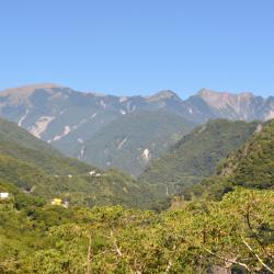
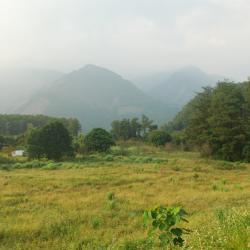
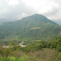
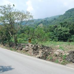
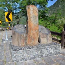
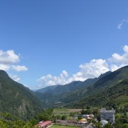
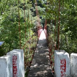
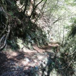
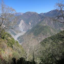
The Guanshan Historic Trail, which crosses the Liugui District of Kaohsiung City and Guanshan Township in Taitung County, was built in 1921. The trail starts from Liugui in the west and ends in Guanshan in the east, with a total length of about 171 km. When the Southern Cross-island Highway was built, it was built alongside the Guanshan Historic Trail.

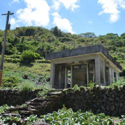
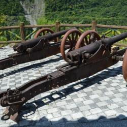
In the early days of Japanese occupation, the Government-General in Taiwan implemented the plan to regulate indigenous peoples. They confiscated guns, which caused the Bunun people to unite in the resistance against Japan. Therefore, the government began to excavate a number of roads across the mountains in the south, set up police patrol posts along the roads, and even deployed forts to suppress the indigenous peoples.

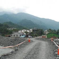
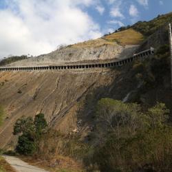
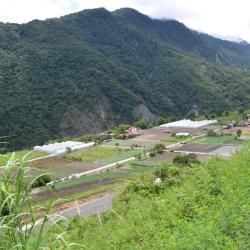
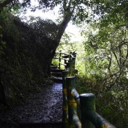
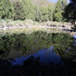
Today, the Guanshan Historic Trail has been replaced by the Southern Cross-island Highway. After the Jiji earthquake and the Typhoo Morakot, the historic trail has been broken into sections and only a part remains.

  • - / -
  • - - -
  • -
  • - -/-
  • -
There is a neat foundation piled stone under the section of the Zhongzhiguan Historic Trail

古道地圖

Attractions
Fuxing Hamlet
2009年莫拉克風災後受創嚴重的復興部落,左下方為荖濃溪支流拉克斯溪,河床上的土石溢流至道路上。
Fuxing Hamlet資訊

The Fuxing hamlet (Uaasik) is located in Fuxingli, Taoyuan District, Kaohsiung City. In the Bunun language, it is called Uaasik, which means a place that grows palms because there are many wild mountain palms here. The locals are more accustomed to using the Japanese translation of Bibiuw (bibiyoshe or Bibiwushe). The people originally lived scattered among the mountains and forests. During the Japanese colonial period, the Japanese implemented the policy of managing the indigenous peoples and forced the relocation of the tribe to concentrate on the left bank of the Laonong River, which is the platform about 2 kilometers east of the confluence of the Laonong River and the Lakesi River. At the end of the Japanese occupation, malaria broke out in the villages,causing the people to migrate, and the population dropped sharply. It was not until after the liberation that the malaria epidemic slowed down that the population gradually returned. At present, people mainly live near the present Fuxing Police Station. Since this hamlet is further away from the Southern Cross-island Highway, the settlements are scattered and small in scale.

Fuxing Police Station (Bibiwu Police Post)
復興派出所(比鼻屋駐在所)
Fuxing Police Station (Bibiwu Police Post)資訊

The abolished Fuxing Police Station was the  Bibiwu Police Post on the Guanshan Historic Trail during the Japanese occupation, and behind it was the Fuxing Branch of Zhangshan Elementary School. The Bibiwu Station was originally located on the west bank of the Laonong River, but was later moved to the site of the Fuxing Police Station on the east bank for reasons of precaution.  The Fuxing hamlet (Uaasik) is located in Fuxingli, Taoyuan District, Kaohsiung City. In the Bunun language, it is called Uaasik, which means a place that grows palms because there are many wild mountain palms here. The locals are more accustomed to using the Japanese translation of Bibiuw (bibiyoshe or Bibiwushe). The people originally lived scattered among the mountains and forests. During the Japanese colonial period, the Japanese implemented the policy of managing the indigenous peoples and forced the relocation of the tribe to concentrate on the left bank of the Laonong River, which is the platform about 2 kilometers east of the confluence of the Laonong River and the Lakesi River. At the end of the Japanese occupation, malaria broke out in the villages, causing the people to migrate, and the population dropped sharply. It was not until after the liberation that the malaria epidemic slowed down that the population gradually returned. At present, people mainly live near the present Fuxing Police Station. Since this hamlet is further away from the Southern Cross-island Highway, the settlements are scattered and small in scale.
 

Meishan Hamlet
梅山部落主要道路,最右邊的建築物是馬舒霍爾文化聚落所,往前是樟山國小梅山分班,馬路走到底可接梅山吊橋
Meishan Hamlet資訊

Meishan Hamlet (Masuhuaz) is located in Meishanli, Taoyuan District, Kaohsiung City. In the Bunun language, it is called Masuhuaz, which means rattan (Calamus jenkinsianus), and it got its name because the area is rich in this kind of rattan. The site of the old Masuhuaz community is above the current hamlet. After moving to the current site in 1961, it was still called Masuhuaz. The name was changed to Meishan after the national government moved to Taiwan because of the abundant plum trees in the area. The Morakot typhoon in 2009 caused subgrade collapse, road surface burial, and broken bridges on the Southern Cross-island Highway. The repair work was extremely difficult. Although the Meishanming Tunnel above the Meishan hamlet did not suffer major damage during the Morakot typhoon, it was damaged by heavy rain in August 2014. A large-scale collapse crushed the Tunnel, and it was not repaired until September 2018. Since the hamlet is the entrance to the mountainous area in the western section of the highway, the restoration of the Meishanming Tunnel was an important indicator of whether the Southern Cross-island Highway can be opened to traffic.

Meishanming Tunnel
從梅山部落入口處眺望南橫公路上的梅山明隧道,此隧道位於梅山部落東南方,2014年8月曾發生大規模崩塌,現在雖已修復,但仍可看到隧道周圍裸露的土石,可以想見工程的艱鉅
Meishanming Tunnel資訊

The Morakot typhoon in 2009 caused subgrade collapse, road surface burial, and broken bridges on the Southern Cross-island Highway. The repair work was extremely difficult. Although the Meishanming Tunnel above the Meishan hamlet did not suffer major damage during the Morakot typhoon, it was damaged by heavy rain in August 2014. A large-scale collapse crushed the Tunnel, and it was not repaired until September 2018. Since the hamlet is the entrance to the mountainous area in the western section of the highway, the restoration of the Meishanming Tunnel was an important indicator of whether the Southern Cross-island Highway can be opened to traffic.

Xiama Hamlet
從南橫公路嘉寶附近眺望下馬部落和中央山脈主稜,部落的房屋緊靠著南橫公路旁。
Xiama Hamlet資訊

The Xiama Hamlet is located in Wulu Village, Haiduan Township, Taitung County, close to the top of the Southern Cross-island Highway, on a slope about 700 meters above sea level. The hamlet was originally located on a hillside about 1 km southeast of the present site and was formed under the Japanese government's forced relocation after the middle of the Japanese occupation. In the Bunun language, this place is called Vauvu, which means spine. It got its name because the mountain looks like a spine from a distance. There are only four Bunun families who originally lived near Vauvu. The Japanese named the place Ivaqo, set up a police post in the area to rule, and began to ask the Bunun people that were living scattered in the adjacent mountainous area to migrate to Ivaqo. In the late Japanese occupation period, Xian became a small settlement of about 10 households. In 1975, due to the collapse of the foundation caused by the typhoon, the government moved the residents from the old hamlet to the present location.

Old Xiama Police Station
舊下馬派出所位於舊下馬部落,是日治時期葉巴哥駐在所,疊石地基和階梯仍保存完整,平台上尚有一棟水泥建築物
Old Xiama Police Station資訊

The Xiama Hamlet is located in Wulu Village, Haiduan Township, Taitung County, close to the top of the Southern Cross-island Highway, on a slope about 700 meters above sea level. The hamlet was originally located on a hillside about 1 km southeast of the present site and was formed under the Japanese government's forced relocation after the middle of the Japanese occupation. In the Bunun language, this place is called Vauvu, which means spine. It got its name because the mountain looks like a spine from a distance. There are only four Bunun families who originally lived near Vauvu. The Japanese named the place Ivaqo, set up a police post in the area to rule, and began to ask the Bunun people that were living scattered in the adjacent mountainous area to migrate to Ivaqo. In the late Japanese occupation period, Xian became a small settlement of about 10 households. In 1975, due to the collapse of the foundation caused by the typhoon, the government moved the residents from the old hamlet to the present location.

Lidao Hamlet
從南橫公路俯瞰利稻平台上的農田和房舍。
Lidao Hamlet資訊

Lidao Hamlet is located in Lidao Village, Haiduan Township, Taitung County, on a flat plateau at the intersection of Lidao River and Xinwulu River. The name of the hamlet comes from the Bunun word "Lito", which refers to the many wild loquats here. During the Republic of China, it was renamed Lidao. In Showa 5 (1930), there were 24 households in Lidao, which were scattered in 10 settlements at that time. From March to August in Showa 8 (1933), due to the impact of the Daguanshan Incident, 16 households with 150 people were moved to the current Lidao area for easy management, forming a collective village. In Showa 15 (1940), for the purpose of promoting rice planting, the Japanese government moved 127 people from 14 households to the current Lidao area, and the scale of today’s Lidao settlement has taken shape.
 

Tianlong Trail
陡峭山壁上的天龍古道。
Tianlong Trail資訊

The Tianlong Trail starts at Tianlong Suspension Bridge at 186K of the Southern Cross-island Highway and ends at 197.2K of the same Highway, with a total length of 1.089 kilometers. It is a shortcut between Lidao and Wulu. In the 4th year of Showa (1929), the Japanese built the section of the Guanshan Historic Trail from Wulu through Lidao to Halibsong, and erected a suspension bridge in the valley between Lidao and Wulu, named "Tianlong Bridge". After crossing the bridge on the Guanshan Historic Trail, it goes up steeply directly to Lidao, which is different from the current route of the Southern Corss-island Highway. After the war, the Tianlong Bridge was in disrepair and impassable. When the Southern Cross-island Highway was being built, it was refurbished in order to transport construction personnel and materials. By 1993, the Tianlong Bridge had become a dangerous bridge, and the historic trail on the other side of the bridge was also abandoned. The Haiduan Township Office then restored the suspension bridge and dug a stone-step trail on the mountain wall on the north side of the suspension bridge. This section of the trail is the Tianlong Trail.

Yaoguaitai
聳立於左岸的一大片臺地即為妖怪臺
Yaoguaitai資訊

Yaoguaitai (Yaoguai Terrace) is located on the platform, right side of Laonong Riverbank in Taoyuan District, Kaohsiung City. It faces Meixiu Terrace on the opposite side, and was originally the place of residence of the Hla’alua tribe. They called it Tapuorokna, which means the monsters’ resting place. In the past, the Pingpu ethnic group of Shishe, who are living in Liugui District today, had fought fiercely at Yaoguaitai in order to resist the influx of Han people. Therefore, it was regarded as a taboo place. However, at the end of the Japanese occupation, the Governor-General in Taiwan began to actively assist in the reclamation of land. Gradually, neighboring tribes moved to this place from old Yusuishe or Shangbaolai.

Today, you can get there when traveling from Liugui to the right bank of the Laonong River. It is on the 10 km point on the Guanshan Historic Trail.

Meilongshe
從南部橫貫公路遠眺荖濃溪對岸的美壠社
Meilongshe資訊

Meilongshe is located on the platform right side of the Meilongshan, opposite the Taluoliu River Estuary in Taoyuan District, Kaohsiung City. The altitude is about 1,000 meters. The traditional territories are distributed in the vast area between Laonong River and Baolai River. No one resides there now as the tribesmen collectively moved to the Kaozhong area. Since the Qing period, Hla’alua tribe is made up of four communities: Paijianshe, Meilongshe, Talashe, and Yan'ershe. The Han people call them Dingsishe, meaning the top four settlements, while the Governor-General in Taiwan called it Shishe.

Today, the Hla’alua people live in the upper reaches of the Laonong River, between Shaonian River and Liumao River, at an altitude of about 500 meters.

Talashe
從南部橫貫公路遠眺塔臘社舊址
Talashe資訊

Talashe is located on the top of the mountain on the northern shore of the Taluoliu River in the Taoyuan District of Kaohsiung City. The altitude is about 700 to 1,000 meters, and the traditional territories of Hla’alua are distributed between Putou River and Taluoliu River. The southernmost territory is Paijianshe. Although the tribesmen moved to Paijianshe for its ease of transportation, no one lives there today. Since the Qing period, Hla’alua tribe has been composed of four communities: Paijianshe, Meilongshe, Talashe, and Yan'ershe. The Han people call them Dingsishe, meaning the top four settlements, while the Governor-General in Taiwan called it Shishe.

Today, the Hla’alua people live in the upper reaches of the Laonong River, between Shaonian River and Liumao River, at an altitude of about 500 meters.


Mashuhor Police Post
馬舒霍爾駐在所的蓄水池,裡面塞滿玻璃瓶
Mashuhor Police Post資訊

Mashuhor Police Post is located on the east side of Meishan Hamlet in Taoyuan District, Kaohsiung City. To get there, enter the industrial road next to the Meishan Youth Activity Center, then walk further for about 1 km. The former site of the Meishan Hamlet is located above the current hamlet. The traditional Bunun name is Masuhuaz, which means yellow rotang palm, because the area is rich in yellow rotang palm. In the post-war period in 1961, the National Government forced the tribes to collectively move here. The place was then renamed to Meishan because of the abundance of plum trees.

Today,  the original building of Mashuhor Police Post no longer exists. Only the foundation of the house, the stone wall, the reservoir, the entrance and exit steps remain but are covered by overgrown grass.


Aisaka (Fengban) Anti-Japan Monument
位於逢坂駐在所舊址附近的抗日紀念碑
Aisaka (Fengban) Anti-Japan Monument資訊

The Aisaka (Fengban) Anti-Japanese Monument is located between Xinwu and Chulai on the Southern Cross-island Highway, near the former site of Fengban Police Post in Haiduan Township, Taitung County. The monument was erected in memory of the Aisaka incident that occurred in the middle of the Japanese occupation period. The incident was caused by the Bunun people of the Bulakusan and Tokoban group attacking the Aisaka Police Post in 1933 and killing the Chief Inspector and his family members. After that, the Governor-General in Taiwan fired at Burakusan Hamlet, formed a search team to attack from Hualien, Taitung and Kaohsiung, and finally arrested the suspects. However, in order to take into account the overall situation, the Governor-General adopted a peaceful punishment and held an apologetic ceremony to accept the people’s submission. In the post-war period, the Haiduan Township Office built a simple monument to commemorate this anti-Japanese incident.

Wulu Hamlet
從南部橫貫公路遠眺霧鹿部落
Wulu Hamlet資訊

Wulu Hamlet, located in Haiduan Township, Taitung County, was an important stronghold for migrating east from Nantou at the turn of the 18th and 19th centuries. It is regarded as the origin of Bunun’s traditional culture in the Haiduan area. The place was traditionally called Bulbul, which is said to be named after a locally grown plant called vulvul. Others say that the name came from the pulpul sound of the spring water emerging from the foot of the mountain. In the middle of the Japanese occupation, the Governor-General in Taiwan forced the Bunun people near the Wulu Terrace to collectively move here, which formed the present Wulu Hamlet. From the late Japanese occupation to the post-war period, many people in Haiduan Village and Kanding Village came from Wulu.


Wulu Fort
位在霧鹿國小後方山丘的霧鹿砲臺
Wulu Fort資訊

The Wulu Fort is located on the hills behind Wulu Elementary School in Haiduan Township, Taitung County. There are two guns that were made in Russia in 1903. They were trophies after the Russo-Japanese War and were transported to Taiwan with the intention to suppress the indigenous peoples. In the middle of the Japanese occupation period, when the Government-General in Taiwan excavated the Xinwu to Wulu section of the Guanshan Historic Trail, a fort was erected here to intimidate the Bunun people. Especially after the Daguanshan Incident in 1932, the Japanese used the strategy of dropping bombs onto uncooperative tribes to suppress the originally fierceful opposing indigenes. In the post-war period, Hu Jinniang, the then mayor of Haiduan Township, retrieved the historic guns that were left abandoned in the warehouse of the Taitung County Police Station and relocated them to the rear of the elementary school.

Tianlong Suspension Bridge
位在天龍飯店後方的天龍吊橋南端
Tianlong Suspension Bridge資訊

The Tianlong Suspension Bridge is located behind the Tianlong Hotel in Haiduan Township, Taitung County. It was built in the valley between Wulu and Lidao on the Wulu-Hari section of the Guanshan Historic Trail, which was built in the middle of the Japanese occupation period.  The mountains on both sides of the bank are steep and the suspension bridge hangs in the sky like a long dragon, hence the name Tianlong Suspension Bridge. 

However, in the early post-war period, the Tianlong Suspension Bridge was impassable due to years of neglect. It was not until the Southern Cross-island Highway was opened that the bridge was restored for the purpose of transporting people and supplies. The original section of the historic trail that leads directly to Lidao was made into the Tianlong Historic Trail, which connects the Tianlong Hotel and the Southern Cross-island Highway. It is also a shortcut from Wulu to Lidao.


Liyuan Police Station
栗園派出所後方的三間警察宿舍
Liyuan Police Station資訊

The Liyuan Police Station, located in Haiduan Township in Taitung County, was originally the Jiemaosi Police Post on the Guanshan Historic Trail during the Japanese occupation. The police station has a spacious  platform, which is now abandoned. Yet the steps and barriers that lead into the front yard are still complete. In the thatch on the hillside behind, there are still the cornerstones of the shrine remaining. There is also a small section of the historic trail there, which is wide and flat. But the trail after entering the orchard was destroyed by reclamation.

The traditional Bunun name of the place where the Liyuan Police Station is located is Haimosu. It was named after a tree that was overgrown in the area. In the post-war period, the National Government changed its name to Liyuan.


Tianchi
天池是一個天然湖泊,為南部橫貫公路上的著名景點
Tianchi資訊

Tianchi, located in the Taoyuan District of Kaohsiung City, is about 2,280 meters above sea level. It is a natural mountain lake formed by faults, collapses, soil and the accumulation of rocks, rain and snow. The lake not only provides water for travelers but is also an important sustaining resource for wildlife. To get there, climb up the stone steps from the back of the Changqing Temple at the 135 km point of the Southern Cross-island Highway. Alternatively, start from Zhongzhiguan parking lot and walk along the Zhongzhiguan Historic Trail. In recent years, religious people have burned paper money and held release ceremonies here, leaving behind creatures and wastes that do not belong here, which greatly affects water quality and ecology.


Zhongzhiguan Historic Trail
中之關古道的路段下方有整齊的地基疊石
Zhongzhiguan Historic Trail資訊

Zhongzhiguan Historic Trail is located between Zhongzhiguan and Tianchi on the Southern Cross-island Highway in the Taoyuan District of Kaohsiung City. It is one of the sections of the Guanshan Historic Trail that is relatively intact. During the Japanese occupation, the Governor-General in Taiwan decided to expand the passage between hamlets located along Xinwulu River and the Laonong River in order to regulate the indigenous peoples. At the same time, construction began at both ends of the Kaohsiung State and Lilong County, excavating towards the Central Mountain Range. The Guanshan Historic Trail was completed in 1931. Today, the Southern Cross-island Highway runs almost along the Guanshan Historic Trail. Among which, there is a 3.5-kilometer-long section of historic trail between Zhongzhiguan and Tianchi that is relatively intact and is called Zhongzhiguan Historic Trail.

Yuhuishan and Yuhuishe
從中之關古道遠眺玉穗山
Yuhuishan and Yuhuishe資訊

Yusuishan (mountain) and Yusuishe (hamlet) are located in the Taoyuan District of Kaohsiung City. It is at an altitude of 3,045 meters. Left behind it are the Yushan peaks, and the large river bed at the foot of the mountain is the Laonong River Valley. The right side of the valley is the former Yusuishe, which was the last base of Lahu·Ali, a Bunun anti-Japanese hero. During the Japanese occupation, the Governor-General in Taiwan decided to expand the passage between hamlets located along Xinwulu River and the Laonong River in order to regulate the indigenous peoples. The Guanshan Historic Trail was completed in 1931.

Today, there is a 3.5-kilometer-long section of historic trail between Zhongzhiguan and Tianchi that is relatively intact and is called Zhongzhiguan Historic Trail.


Zhongzhiguan Police Post
中之關駐在所的解說石亭,內有解說牌
Zhongzhiguan Police Post資訊

The Zhongzhiguan Police Post is located in the Taoyuan District of Kaohsiung City. It is an extremely important stop on the Guanshan Historic Trail because it overlooks Yusuishe from there, and monitors the then Bunun chief, Lahu·Ali, who lived opposite Zhongzhiguan, on the upper reaches of the Lunong River. Lahu·Ali, who has fought continuously against the Japanese for 20 years, once visited the Zhongzhiguan Police Post twice and came to a peaceful settlement there. In fact, the Zhongzhiguan Police Post had a huge establishment, and the police department with the highest rank was stationed here for a long time.

Today, the historic trail section between Tianchi and Zhongzhiguan is made into hiking trails by the Yushan National Park. There are also tourist rest stops and information boards at the ruins of the Zhongzhiguan Police Post.