Kiwit Historic Trail

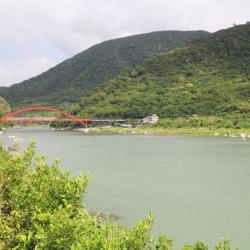
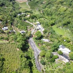
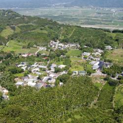
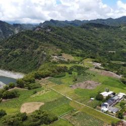
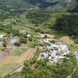
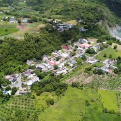
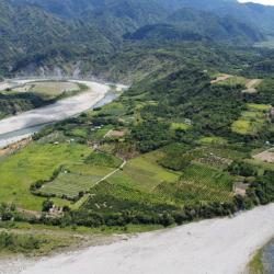
Located in Ruisui Township, Hualien County, the Kiwit Historic Trail is about 41 km long. Its starting point is from Mt. Kilaya, which is the holy mountain of the Amis tribe. Legend has it that the Amis people migrated from this holy mountain to various parts in the east.

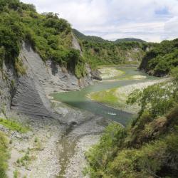
In the past, the ancestors of Kiwit hamlet slowly migrated down from Mt. Kilaya, which is more than 900 meters above sea level, to today’s Kiwit hamlet in order to find clean water sources and ideal hunting grounds. Due to trading needs and transportation to the outside, a path was created along the Xiuguluan River that connects the port in the east and Ruisui in the west.


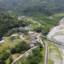
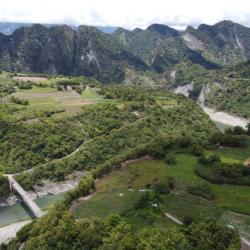
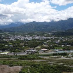
Until 1987, the Taiwan Provincial Government expanded it into the Ruigang Industry Road (aka Hualien Country Road 64). Today, there are still several ruins of this trail on the side of the road.

  • - / -
  • - - -
  • -
  • - -/-
  • -
Birds’ eye view of Upper Chimei (Kiwit) Terrace, and the Ruigang Industry Road on the top-left.

古道地圖

Attractions
Sanfu Bridge Hamlet
空拍三富橋部落
Sanfu Bridge Hamlet資訊

Sanfu Bridge Hamlet is located in Jingpu Village, Fengbin Township, Hualien County. It is an Amis hamlet close to the Pacific Ocean. In the native language it is called Sahfongan, which refers to low-lying sandy land. It is located about 1.5 kilometers south of the Jingpu hamlet. This place was originally the arable land of the Jingpu (Cawi) hamlet, where people began to migrate from the Jingpu  to here in 1954. After the 1980s, many people separated from Jingpu, and gradually formed a new settlement, named Sahfongan. There are currently about 30 households. Between July to September 1959, there were 4 strong typhoons. In the same year, Jingpu School was established in Sanfuqiao hamlet, and later moved to its current location in Jing'an.

Ci'poran Island
從靜安眺望奚卜蘭島。
Ci'poran Island資訊

Ci’poran Island is located at the estuary of Xiuguluan River. In Amis language it is called cipo or ci’poran, which means island in the river. In the 8th year of Jiaqing (1803), Japanese fisherman and others drifted here and named the place ciporan. It was later changed to "Luoge Island", which means hunched or hunchback. In the 4th year of Emperor Guangxu of the Qing Dynasty (1878), the "Map of Mountains Before and After Taiwan" named the lace Lion Ball Mountain, and later Lion Ball Island. The Japanese called it Bantian Island. According to the Gangkou Amis legend, this place is where their ancestors first settled in Taiwan, and therefore, it is an important ritual site for them to hold sea rituals. There is a prehistoric culture on the island, where there are still some stone tools and Amis-style pottery fragments left on the surface. The highest altitude on the island is about 40 meters, and the island covers an area of ​​about 10 hectares. On the north and south sides of the island, under the combined action of rivers, waves and tides, many gravels are deposited at the estuary to form natural embankments whose shapes change with the seasons. Ci’poran Island is now listed as a nature reserve and cannot enter without an application.

Changhong Bridge
從靜浦部落眺望新長虹橋。
Changhong Bridge資訊

The New Changhong Bridge is a red arch bridge spanning both sides of the Xiuguluan River estuary. It is an important bridge connecting the Jingpu hamlet and the Dagang hamlet. There is a boat dock below the bridge, and at the south end of the bridge is the Xibulan Visitor Center. Next to the new Changhong Bridge is the old Changhong Bridge. The old bridge was completed in May 1968. It is 120 meters long and was the first cantilever single-arch concrete bridge in Taiwan. Due to the long term traffic use of the bridge, it became a bridge for pedestrians when the new bridges was completed and opened to traffic in January 2013. The magnificent new bridge can be seen from the old bridge. The new Changhong Bridge is 185 meters long, has eight semi-circular viewing platforms on the bridge, where you can overlook the boats passing underneath, as well as the beautiful scenery of Xiuguluan River estuary and Ci’poran Island.

Sea Ritual Plaza
港口部落的海祭場
Sea Ritual Plaza資訊

The sea ritual plaza of the Gangkou tribe is the place where the Amis people hold fishing sacrifices. The Amis people believe that their ancestors came across the sea, so they hold sea sacrifices to thank the god of the sea for protecting their ancestors to land. Different regions has different name for the fishing festival. It is called Milalikis by the northern Nanshi Amis, and Misacepo' by the Coastal Amis. Different regions also hold the festival at different times although it is held before the harvest festival, roughly from June to August. The fishing festival is a concrete manifestation of the Amis people's gratitude to the gods of the sea and the gods of heaven and earth. They believe that the natural world is dominated by many gods. They respect nature and hope to catch abundant fish and shrimp every year. The biggest taboo in the sea festival activities of the Gangkou hamlet is that women are not allowed to participate in the ritual. They believe that if women participate, there will be no catch for the year.

Tobacco Barn
 溫泉部落內一座保存完整的菸樓,位於便利商店對面的小巷子。菸樓是用來燻製和儲存菸葉的場所,此棟菸樓屬於大阪式菸樓,影像中可見到屋頂上突出的部分為排煙口。
Tobacco Barn資訊

The form of tobacco barn can be divided into two styles: Osaka style and Hiroshima style. The smoke outlet of the Osaka-style tobacco building protrudes from the roof. It is tall, large, and the smoke exhaust effect is good. The curing time is short, but the quality of the cured tobacco leaves is poor, and because of the large wind surface, it is easy to be caught in a typhoon. blow bad. The Hiroshima-style tobacco building is just the opposite. The smoke exhaust port is located on the slope of the roof, and the smoke output is small, so the curing time is longer, so the quality of the tobacco is better. Although it is less afraid of typhoons, it is prone to fire. During the Japanese colonial period in Ruixiang Village, Japanese tobacco farmers came here to plant tobacco. At the beginning, most of them recruited local Amis people as tobacco workers. After the war, this area was designated as a professional tobacco production area. It has become the most important industry for residents, and there were dozens of tobacco buildings. Today, there are only 14 Japanese Osaka-style tobacco buildings preserved in the village, which is the area with the most preserved tobacco buildings in Ruisui Township.

Hongye Village
空拍紅葉新村
Hongye Village資訊

The left half of the settlement in the image belongs to Hongye Village, Wanrong Township, which is the Hongye Tribe of the Truku group, and the right half is Ruixiang Village, Ruisui Township, which is the Amis Hot Spring Tribe. Hongye Village is located on the left bank of Hongye Stream, and is adjacent to Ruisui Hot Spring in the east. In the early days of Hongye, the Amis and Bunun people lived successively. The Amis people called the area Koyo because of its many mountain cats there, namely the masked palm civet, and in the Amis language it is called Koyo. After the Japanese occupation, Koyo was translated to the japanese word koyo, which means autum leaves, and  “Hongye” in chinese character. After the 8th year of the Showa era (1933), the Truku people moved in one after another. Because of the narrow terrain and lush vegetation, the Truku language called it Utux Qrunang, which was later transliterated as "Wudof Kelonan". This was later shortened to "Aifunan", which is the name of the place that the people use today.


Xibao Hamlet
空拍西寶部落
Xibao Hamlet資訊

There is a Hongye bridge on the right side of the tribe leading to the Hongye hamlet, and under the bridge is the Hongye Stream. The Xibao hamlet belongs to Hongye Village, Wanrong Township. It is located on the south bank of Hongye Stream and at the west end of Hongye Bridge. The Hongye area was inhabited by the Amis and Bunun people successively in the early days. After the 8th year of the Showa Period (1933), the Truku people moved in one after another. Most of the early tribes lived on the left bank of Hongye Stream west of Ruisui Hot Spring and the southern foothills of Hutou Mountain. A small part lived near the present Hongye Hot Spring, at the northern foot of Dijia Mountain. Because it is on the opposite bank of Hongye tribe, it is called "Xibao", which is the Truku word Sipaw, meaning the opposite side.

Hongye Hot Spring
紅葉溫泉
Hongye Hot Spring資訊

Hongye Hot Spring is located in Hongye Village, Wanrong Township. It is opposite to Ruisui Hot Spring across Hongye Stream, so it is also called Inner Hot Spring. It is about 5 kilometers away from Ruisui Station. The spring water comes from the foothills of Jiaxing Mountain. It is an alkaline hydrogen carbonate spring. The water quality is clear and transparent, colorless and odorless. The spring temperature is about 47 degrees Celsius, and the hydrogen ion concentration is 6.6. During the Japanese occupation period, a hostel was built here, and it continues to operate under the name of "Hongye Hot Spring Hostel". The old Japanese-style wooden buildings are still intact. The handwritten signboard at the entrance is very vintage. The wooden sliding doors, wooden window frames, wooden floors and tatami floors are full of Japanese style. Due to inconvenient transportation, there are few tourists, but it is far away from the hustle and bustle and the environment is very quiet.

Lumozai Hamlet
位在瑞穗鄉舞鶴台地上四個阿美族部落之一魯摸仔部落
Lumozai Hamlet資訊

Lumozai is one of the four Amis hamlets on the Wuhe Terrace in Ruisui Township (the other three hamlets are Saobading, Maliyun and Jianana). The Japanese once planted coffee and trial planted tea trees on the Wuhe Terrace. After the war the Nationalist government began promoting tea cultivation in the Wuhe area, thus gradually forming the tea village look of today's Wuhe Terrace. Lumozai hamlet is located in the hill on the northeast side of the Wuhe Platform, on the top of the northeast hill of the Jianana (Kalala) hamlet. This place is surrounded by three sides of mountains, with only a gap in the west, which forms a tuyere, and is called Lumoc in the Amis language. Lumoc was once an ancient Amis tribe. It was originally composed of four Amis clans, Fasay (also known as Vasai), Talakop, Inato, and Siracay. They originally lived in the south but migrated here due to Bunun’s invasion. The present residents are mostly from Kiwit. There used to be more than 20 households at the most, and now there are only a few households left.

Jianana Hamlet
加納納部落空拍景色
Jianana Hamlet資訊

The Jianana hamlet is located in a mountain pass in the northeast of the Wuhe Platform. As the terrain is shaped like a basket, it is called Kalala in the Amis language, which means basket. The name of this hamlet was first seen in the "Map of Taiwan" in the 4th year of Guangxu (1878). At that time, the hamlet was located on the top of Lumoc Mountain in the northeast of the current site. Later, due to the drought on the top of the mountain, it moved to the current site. The records from the end of the Qing Dynasty period kept the name of the hamlet however, no one lived there then. Then in the report of the Taitung Reclamation Office in the 30th year of the Meiji Period (1897), there were still records of 7 households with 33 people in Jianana hamlet. It can be seen that the Amis people of the Jianana tribe have moved in and out several times in the past hundred years, because the Wuhe Terrace has been an area where the Bunun people have frequent activities since the 18th century, making the Amis people unable to settle here for long. In the 11th year of the Showa era (1936), a Japanese company planted tea on the hills on the southeastern side of the hamlet and introduced 10 Hakka tea farmers from Beipu, Hsinchu. Currently there are about 50 households remaining in Jianana hamlet.

Jingpu Hamlet (Cawi)
從空中俯瞰靜浦部落
Jingpu Hamlet (Cawi)資訊

The Jingpu hamlet is in Fengbin Township, Hualien County. It is located on the coastal terrace on the south bank of the Xiuguluan River estuary. The traditional name is Dapudapu, which means sloping land.

In the past, the Amis people established the Cawi hamlet on higher terraces, around the back of present Jingpu Elementary School.  At the end of the Qing period, Wu Guangliang, the commander-in-chief of all roads in Houshan, had conflicts with the Amis people of Jingpu and Gangkou area for excavating roads from Shuiwei to Dagangkou (Cepo’). Troops were sent to suppress and massacre the opposing Amis people, which resulted in the Cepo’ incident.  After the aftermath subsided, the people moved back to their old hamlet subsequently. But because the old hamlet was not livable, they settled by the seaside on the hillslope on the eastern side of Jianana instead. They continued using the name of the old hamlet, Cawi, until they renamed it to Jingpu in 1937.

Jing'an Hamlet (Tisilan)
從空中俯瞰靜安部落
Jing'an Hamlet (Tisilan)資訊

The Jing’an Hamlet is located on the south bank of the Xiuguluan River’s estuary in Fengbin Township, Hualien County. Due to its flat terrain, it is on the same straight line as Jingpu Hamlet. The traditional name, Tisilan, is derived from the Amis word “Saadisi”, which means on a straight line. At the end of the Qing period, due to the Cepo’ incident, the Qing soldiers originally stationed in Dabei moved here and renamed it Dagangkou Camp. Later, the Han people moved in, and the place is known as Da Pian Yuan. It was not until the post-war period, when house number plates were issued, that the place was renamed to Jing’an. In the 1980s, due to the increased population, Jing’an hamlet gradually got separated from the bigger Jingpu hamlet. At present, the Jing'an hamlet is mainly concentrated by Han people on both sides of the provincial highway 11.


The Cepo’ Incident Monument
位於靜浦國小內的大港口事件紀念碑
The Cepo’ Incident Monument 資訊

The Cepo’ Incident Monument is located inside Jingpu Elementary School in Fengbin Township, Hualien County. It was established in 2014, which is the 127th anniversary of the Cepo’ Incident.

The Cepo’ incident happened at the end of the Qing Dynasty, when Wu Guangliang, the commander-in-chief of all roads in Houshan, was resisted by the Amis people of Jingpu and Gangkou area for excavating roads for Shuiwei to Dagangkou port (Cepo’). Therefore, in 1877, General Lin was sent to lead a troop to suppress the Amis people. Almost a hundred Amis people were killed at the incident, and the surviving tribesmen fled, dispersed to the east coast and the Huadong Rift Valley. The area around Jingpu became the base camp for the Qing troops.


Dagangkou Hamlet (Laeno)
從空中俯瞰大港口部落
Dagangkou Hamlet (Laeno)資訊

Dagangkou Hamlet is located on the north bank of the Xiuguluan River estuary in Fengbin Township, Hualien County. The traditional name of the place is Lanun, which means the village below, and the traditional name of the hamlet was Ciporan. During the Qing period, the hamlet was called Sipuolan, Xuepuolan, Xiuguluan, Xiuguluan, Zhiwulan, and so on. It was not until 1887 when Puyuma and Ouyang Jun opened the port that the name was changed to Dagangkou. In the same year, the Dagangkou (Cepo’) incident occurred. After the incident, the tribesmen who had moved to other places were called to return to the community. They chose a settlement north of the original site, which is the present Gangkou hamlet. During the Japanese occupation, due to the gradual population increase, some people began to move south to live in the Dagangkou hamlet.

Gangkou Hamlet (Makotaay)
從空中俯瞰港口部落,右側山坡為公墓區
Gangkou Hamlet (Makotaay)資訊

The Gangkou Hamlet is located about 500 meters from the north bank of the Xiuguluan River in Fengbin Township, Hualien County. The traditional name is Makotaay, which means the muddy stream because there is a small stream on the north side of the hamlet and when it rains the stream becomes muddy. In the past, the ancestors of the Gangkou Hamlet lived in the old Ciporan Hamlet. After the Cepo’ Incident in 1887, the tribesmen who had moved to other places were called to return to settle in a hamlet not far from the original site, which is the present Gangkou Hamlet.


Shitiping
從空中俯瞰石梯坪
Shitiping資訊

Shitiping is located on the coastal reef area on the south side of Shiti Port in Fengbin Township, Hualien County. The traditional name is Tilaan, which means a place to stay overnight. Before the provincial highway 11 was established, people heading north to Maogong had to travel on foot and on return, they needed to stay overnight in this place. During the Qing period, when the commander-in-chief Wu Guangliang led his troops here to open the road, he saw the stair-like formation of the rocks and named the place Shitiping (Rock Stairs).  Over the past 100 years, the Kavalan, Amis, and Han people have successively moved to the vast land at the foot of the mountain on the east side of Shitiping. By the 1990s, the natural sea-eroded reef landscape of Shitiping had become a famous tourist attraction.


Upper Chimei (Kiwit) Terrace
從空中俯瞰奇美上臺地,左上可見瑞港公路橫越
Upper Chimei (Kiwit) Terrace資訊

The Upper Chimei Terrace is located on the highland south of the river terrace formed by the alluvial Xiuguluan River in Ruisui Township, Hualien County. It is the main location of the Chimei hamlet. A large number of cultural relic pottery of the Jingpu hamlet have been found behind the present Chimei Elementary School. Hence, the site is presumably the Nalomann hamlet, where the ancestors lived.

The traditional name of the place is Kiwit, which means crabgrass because according to legend, crabgrass was abundant here. However, the Han people misinterpreted Kiwit as Chi-mi, which means a peculiar and mysterious place. In the Japanese Occupation period, the place was renamed to Chimei.

In the past, tribal people only used hunting roads or going down the stream to get to the outside world. In the Qing period, General Wu Guangliang built plank roads, which continued to be used during the Japanese occupation. Finally, in 1986, the plank road was widened and built into Ruigang Industry Road (also known as Hualien County Road 64). 


Upper Chimei (Kiwit) Hamlet
從空中俯瞰奇美上部落,學校附近是舊部落位置
Upper Chimei (Kiwit) Hamlet資訊

The Chimei Hamlet is located on the highlands formed by the alluvial river terraces of the Xiuguluan River in Ruisui Township, Hualien County. It is divided into upper and lower hamlets. The Upper Chimei Hamlet is located on the east side of the current Chimei Elementary School. It is about 100 meters above sea level and was where the hamlet first established. The traditional name of the place is Lingpawan, which means above. During the Japanese occupation, the people living in the Upper Chimei Hamlet migrated to the lower terraces. At present, about 20 households still live in the upper hamlet, though most of them are recent immigrants, including Bunun, Amis and Han people.

Lower Chimei (Kiwit) Hamlet
從空中俯瞰奇美下部落,派出所也位於此處
Lower Chimei (Kiwit) Hamlet資訊

The Chimei Hamlet is located in the highlands formed by the alluvial river terraces of the Xiuguluan River in Ruisui Township, Hualien County. It is divided into upper and lower hamlets. The lower hamlet is where the police station is located, and where Chimei residents currently live. The traditional name of the hamlet is Lanar, which means below, as it is located at the lower level of the Chimei terrace.  Although the terrain is flat, the bottom is mostly sand and gravel. During the Japanese occupation, the Government-General in Taiwan ordered the residents to move from the upper terrace to the lower terrace due to insufficient water sources.


Chimei (Kiwit) Hamlet
從空中俯瞰奇美部落,部落集中區域為下部落
Chimei (Kiwit) Hamlet資訊

The Chimei Hamlet is located on the highlands formed by the alluvial river terraces of the Xiuguluan River in Ruisui Township, Hualien County. It is divided into upper and lower hamlets. The upper hamlet was where the tribe first established, while the lower hamlet is where the residents currently live. The traditional name of the Chimei Hamlet is Kiwit, which means crabgrass, because according to legend, there was abundant crabgrass here. However, the Han people pronounced it as Chimi. Until the Japanese occupation, the Government-General in Taiwan ordered the residents to move from the upper terrace to the lower terrace and renamed it to Chimei. 

In the past, tribal people only used hunting roads or going down the stream to get to the outside world. In the Qing period, General Wu Guangliang built plank roads, which continued to be used during the Japanese occupation. Finally, in 1986, the plank road was widened and built into Ruigang Industry Road.

Chimei (Kiwit) River Terrace
奇美河階西側的地層結構,奇美部落即位於此河階面上
Chimei (Kiwit) River Terrace資訊

Chimei River Terrace of Ruisui Township, Hualien County, is located at the confluence of the Xiuguluan River and Chimei River. The single-sided mountains, circulation mounds and river terraces in this area are quite developed, and the Chimei Hamlet is located on the platform of this river terrace. Chimei River was originally a turbid current that entered the sea. But during the uplift of the coastal mountains, it continued to erode toward the source, which changed its course and converged into the current Xiuguluan River. In addition, the Chimei Fault is the most important active fault in the coastal mountains, with a total length of more than 30 km. The stratigraphic structure of the Chimei River on the west can be seen from Ruigang Industry Road.

Xiuguluan River
從奇美部落往西眺望秀姑巒溪,右下為奇美河階
Xiuguluan River資訊

The Xiuguluan River begins from the Central Mountain Range. It runs north along the Huadong Rift Valley, and turns eastward at Ruisui Township in Hualien County. Then it cuts across the coastal mountains and finally flows into the Pacific Ocean at Dagangkou (Cepo’) Hamlet. It is the largest river in eastern Taiwan with a total length of about 104 km. Also, it is the only river in Taiwan that cuts through the coastal mountains. During the process of cutting through the coastal mountains, the Xiuguluan River also cuts many steep gorges, resulting in some quite developed meander and river terraces, such as Dewu River Terrace, Monkey Mountain, and Chimei River Terrace. This makes an excellent classroom for observing geology or topography.

Houzi Shan (Monkey Mountain)
從瑞港公路眺望猴子山
Houzi Shan (Monkey Mountain)資訊

Houzishan (Monkey Mountain) is a river terrace along the Xiuguluan River that is located on the east side of the Dewu river terrace in Ruisui Township, Hualien County. Its traditional name is Kawasan, which means a place where gods and ghosts appear. Therefore, it is also called Ghost Mountain. It is said that macaques came here to forage in the past. Xiuguluan River is the largest river in eastern Taiwan, with a total length of about 104 km. In the process of cutting through the coastal mountains, many steep canyons have also been formed, resulting in developed meanders and river terraces, such as Dewu River Terrace, Monkey Mountain, and Chimei River Terrace. This makes an excellent classroom for observing geology or topography.

Dewu River Terrace
從遠處眺望德武河階
Dewu River Terrace資訊

Dewu River Terrace is located on the east side of the confluence of Xiuguluan River and Fuyuan River in Ruisui Township, Hualien County. It is the starting point where Xiuguluan River cuts through the coastal mountains. 

The traditional name is Lulnu, which means paper mulberry because in the past, there were many wild paper mulberry trees here. It is also an area where the Amis people do dry farming and grazing. Overlooking from the Ruigang Industry Road, it is clear that the Dewu River Terrace descends from south to north. This shows that the river is continuously migrating to the north during the downward cutting process, which results in asymmetric growth meanders on both sides of the river bank. In addition, there is a prehistoric cultural site on the hillside of the Dewu River Terrace as fragments of plain pottery from the Jingpu hamlet have been found. This presumes that this was where the Amis people lived in the early days.


Ruisui
從遠處眺望瑞穗聚落
Ruisui資訊

The formation of settlements in Ruisui Township, Hualien County, began during the Japanese occupation, when free immigration was encouraged. In 1926, Japanese tobacco farmers arrived in Ruibei Village to promote tobacco leaf cultivation. Government-run immigrants from other areas in the Karenko Prefecture (now Hualien County) were successively moved here to establish immigrant settlements specializing in tobacco leaf production. In the post-war period, the National Government re-divided the Ruisui Immigrant Village into four villages. At that time, the industry was still tobacco growing. However, in the 1980s, the tourism and boating industry on the Xiuguluan River emerged, which drove a rapid growth of the local economy. Most of the residential buildings have been converted into modern reinforced concrete buildings.

Ruiliang
瑞良村的中山路沿線為人口集中之處
Ruiliang資訊

Ruiliang Village, in Ruisui Township, Hualien County, sits on the west bank of the confluence of Malangou Creek, Hongye Creek and Xiuguluan Creek. It is a flat sedimentary plain.

During the Qing period, the Feihu Army once camped here, and called it the Shuiwei Camp. Under the changes of policies from excavating mountains and managing indigenes to militia settlement, this place became Shuiwei village, which is the present Ruiliang village. Due to the tobacco industry immigration plan during the Japanese occupation, many immigrants began to move into Ruisui Village. In addition to planting tobacco leaves, sugarcane was still dominantly cultivated in the Linxi area. In the beginning of the post-war period, the southern part of the immigrant village was separated, and the new Ruiliang Village was established.


Saoba Stone Pillars (Satokoay)
掃叭石柱遺址位於瑞穗鄉舞鶴村的舞鶴臺地上
Saoba Stone Pillars (Satokoay)資訊

The Saoba Stone Pillar site is located on the Wuhe platform that is surrounded by Xiuguluan River and Hongye River in Wuhe Village, Ruisui Township, Hualien County. It belongs to a branch of the Puyuma Culture of the Neolithic Age. There are two slabs on the site, one tall and one short. The taller stone pillar is about 6.7 meters tall. The pillars were discovered in 1925 by Koizumi Tetsu, a reporter who worked for the Asahi Shimbun in Osaka during the Japanese occupation. Four years later, the Government-General in Taiwan launched the first investigation of the site. There are rich myths and legends of the Saoba Stone Pillars to the people of the Chimei Hamlet. The pillars are important sacred symbols for Amis people and the founding of the Chimei community and the establishment of Chimei Hamlet.

Wuhe Terrace
舞鶴臺地上的茶園和茶莊,遠處河床為秀姑巒溪
Wuhe Terrace資訊

Wuhe Terrace in Ruisui Township, Hualien County, is located southwest of the confluence of Xiuguluan River and Hongye River. The cultivation began during the Japanese occupation, when Japanese companies established the Hualien Port Coffee Farm here and recruited Taiwanese immigrants to grow coffee. Hakka immigrants from the Taoyuan, Hsinzu and Miaoli area are the mainstays. Workers’ accommodations were built in the area of Saobading and gradually a small settlement was formed. Unfortunately, the originally planned tea colonization plan could not be successfully carried out due to the outbreak of the Pacific War. Until the post-war period, the National Government began to promote tea cultivation on the Wuhe Terrace. In its heyday, the tea plantation once covered 300 hectares and became the main tea-producing area in the east. The look of the tea village has been maintained to this day.